Next week still looks rather benign in the surf department but we have a couple of areas to keep a watch on. More in the Forecaster Notes.
Primary tabs
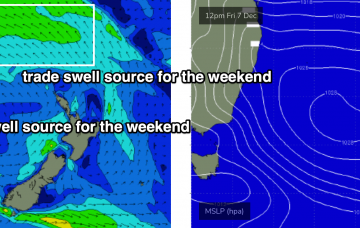
/reports/forecaster-notes/sydney-hunter-illawarra/2018/12/05/building-trade-swell-ahead-though-only
thermalben
Wednesday, 5 December 2018
/reports/forecaster-notes/sydney-hunter-illawarra/2018/12/03/couple-days-southerly-swell-then-not-lot
thermalben
Monday, 3 December 2018
A strong front pushing across the Tasmanian region today will generate a couple of south swells for the next few days. More in the Forecaster Notes.

/reports/forecaster-notes/sydney-hunter-illawarra/2018/11/30/stacks-surf-offer-and-possible-cyclone
thermalben
Friday, 30 November 2018
Long term prospects however look very promising for some parts of the East Coast - hopefully Southern NSW. More in the Forecaster Notes.

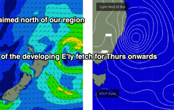
/reports/forecaster-notes/sydney-hunter-illawarra/2018/11/28/lots-swell-and-wind-couple-pockets-fun
thermalben
Wednesday, 28 November 2018
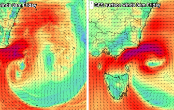
A broad E'ly tending E/NE fetch on the SE flank of the Tasman Low will remain active all the way from Thursday through Sunday morning, but unfortunately it’ll be aimed towards Tasmania.
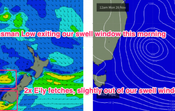
/reports/forecaster-notes/sydney-hunter-illawarra/2018/11/26/no-shortage-surf-complex-mid-week-tasman
thermalben
Monday, 26 November 2018
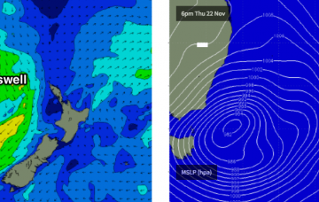
This new Tasman Low looks like it’ll pack a punch, but in contrast to the standard system we see in this neck of the woods, it’s expected to be positioned quite north in latitude.
/reports/forecaster-notes/sydney-hunter-illawarra/2018/11/23/stacks-south-swell-ahoy
thermalben
Friday, 23 November 2018
A deepening Tasman Low is expected to meander slowly through the western Tasman Sea for the next few days, and will deliver an extended period of short range south swell to our coast. More in the Forecaster Notes.
/reports/forecaster-notes/sydney-hunter-illawarra/2018/11/21/great-run-surf-ahead-most-beaches
thermalben
Wednesday, 21 November 2018
Satellite data over the last few days has showed our fetch off New Zealand’s South Island to be quite strong. Even better, we’re looking at locally freshening NW tending W/NW winds. It’ll be well worth coordinating some water time. More in the Forecaster Notes.
/reports/forecaster-notes/sydney-hunter-illawarra/2018/11/19/excellent-run-swells-ahead-under-wintry
thermalben
Monday, 19 November 2018
We have a wide range of swells on the way, which is very exciting.
/reports/forecaster-notes/sydney-hunter-illawarra/2018/11/16/stacks-swell-ahead-though-brief-windows
thermalben
Friday, 16 November 2018
Looks like a reasonably fun weekend of waves across the coast, though it’ll be a little undersized early Saturday morning.

/reports/forecaster-notes/sydney-hunter-illawarra/2018/11/14/plenty-fun-surf-ahead-gotta-pick-windows
thermalben
Wednesday, 14 November 2018
We have a better swell source on the way. A broad trough of low pressure between New Zealand and Fiji is expected to muscule up over the coming days, reaching maximum strength on Thursday though aimed mainly towards locations further north.