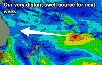
Weak E trade swell allows smaller wave options before things get a bit more active next week.
Primary tabs
/reports/forecaster-notes/south-east-queensland-northern-new-south-wales/2021/02/24/relatively-quiet
James KC
Wednesday, 24 February 2021
/reports/forecaster-notes/south-east-queensland-northern-new-south-wales/2021/02/22/one-last-pulse
James KC
Monday, 22 February 2021
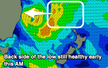
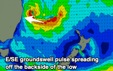
One last pulse from that low and then a relatively quiet end to the week.
/reports/forecaster-notes/south-east-queensland-northern-new-south-wales/2021/02/19/solid-waves
James KC
Friday, 19 February 2021
A solid weekend of waves with better conditions on the cards. Next week we'll see a return to your more typical summer conditions.
/reports/forecaster-notes/south-east-queensland-northern-new-south-wales/2021/02/17/plenty-waves
James KC
Wednesday, 17 February 2021
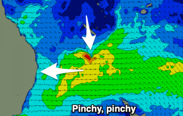
Chunky SE swell turning E and then a low mixing it all up for a dynamic week of waves.
/reports/forecaster-notes/south-east-queensland-northern-new-south-wales/2021/02/15/stormy-wet-week
James KC
Monday, 15 February 2021
Plenty of swell, but winds will be mostly onshore and options limited to southern corners.
/reports/forecaster-notes/south-east-queensland-northern-new-south-wales/2021/02/12/average-weekend
thermalben
Friday, 12 February 2021
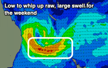
While all of this is going on, a weak tropical low near Fiji this weekend will have travelled south, before developing into an impressive multi-centred low pressure system off the West Coast of New Zealand’s North Island by Monday.
/reports/forecaster-notes/south-east-queensland-northern-new-south-wales/2021/02/10/hang-in-there
thermalben
Wednesday, 10 February 2021
Some modeling suggests this low will merge with the aforementioned broad troughy feature across the western Tasman Sea, forming a large, multi-centered low pressure system across the greater Tasman through the middle of next week.
/reports/forecaster-notes/south-east-queensland-northern-new-south-wales/2021/02/08/flag-the-short
thermalben
Monday, 8 February 2021
You know what? Take the next three days off. It ain’t really worth it. Especially given the incredible couple of weeks we’ve had. But.. there are waves ahead.

/reports/forecaster-notes/south-east-queensland-northern-new-south-wales/2021/02/05/dont-stop-till
thermalben
Friday, 5 February 2021
Incredibly, we’ve got more of the same for the weekend.
/reports/forecaster-notes/south-east-queensland-northern-new-south-wales/2021/02/03/rinse-and-repeat
thermalben
Wednesday, 3 February 2021
TC Lucas will remain slow moving south of New Caledonia for a few days. Current model guidance suggests a reintensification overnight Thursday into Friday morning (see below), aimed perfectly within our swell window.