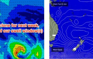
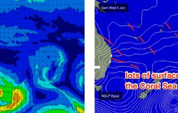
The weekend’s Tasman/Coral Sea ridge will be anchored across the Central Queensland coast by a coastal trough. This is expected to weaken early next week, and at the same time a new tropical depression is expected to form south of the Solomon Islands.
Primary tabs
/reports/forecaster-notes/south-east-queensland-northern-new-south-wales/2017/01/06/fun-trade-swell
thermalben
Friday, 6 January 2017
/reports/forecaster-notes/south-east-queensland-northern-new-south-wales/2017/01/04/rinse-and-repeat
thermalben
Wednesday, 4 January 2017
Although Monday’s forecast for the second half of this week was hardly stellar, the outlook has downgraded a little across some regions, over the last few days.
/reports/forecaster-notes/south-east-queensland-northern-new-south-wales/2017/01/02/freshening-trade
thermalben
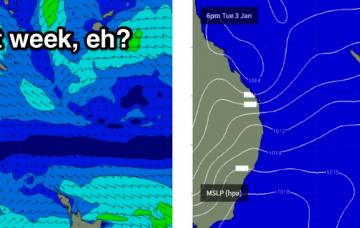
Monday, 2 January 2017
Model data has the S’ly change into the Gold Coast just after midnight tonight, reaching the Sunshine Coast around dawn.
/reports/forecaster-notes/south-east-queensland-northern-new-south-wales/2016/12/30/poor-weekend
thermalben
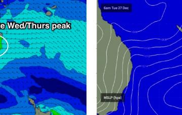
Friday, 30 December 2016
Throughout Wednesday and into Thursday we’ll also start to see a building E’ly swell from the top of a broadening Tasman high.
/reports/forecaster-notes/south-east-queensland-northern-new-south-wales/2016/12/28/plenty-east-swell
thermalben
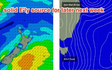
Wednesday, 28 December 2016
A broad fetch of easterly winds through the lower Coral Sea associated with a Tasman high and a small tropical depression are generating an easterly swell that’s expected to reach a peak on Thursday, before easing into Friday.
/reports/forecaster-notes/south-east-queensland-northern-new-south-wales/2016/12/26/stacks-easterly
thermalben
Monday, 26 December 2016
We’re looking at a slow increase in size over the coming days towards a plateau in and around very late Wednesday through Thursday.
/reports/forecaster-notes/south-east-queensland-northern-new-south-wales/2016/12/23/steady-east
thermalben
Friday, 23 December 2016
Jeez, next week looks very exciting.
/reports/forecaster-notes/south-east-queensland-northern-new-south-wales/2016/12/21/anchored-ely
thermalben
Wednesday, 21 December 2016
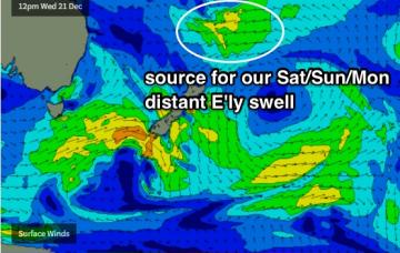
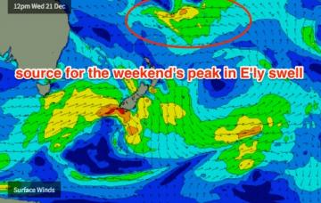
Plenty of decent windows of good conditions with a lully E'ly swell, initially reaching a peak around Sun but with more swell due through all of next week (I'm yet to see a definitive break in the pattern).
/reports/forecaster-notes/south-east-queensland-northern-new-south-wales/2016/12/19/extended-run-fun
thermalben
Monday, 19 December 2016
We’ll see steady surf from the east every day, so you’ll just have to work around the local winds.
/reports/forecaster-notes/south-east-queensland-northern-new-south-wales/2016/12/16/choose-your-own
thermalben
Friday, 16 December 2016
From late Monday or Tuesday onwards, we will also start to see a building E/NE swell originating from a broadening E'ly fetch around the southern flank of TD04F (a tropical depression currently delivering a deluge to Fiji) which may be upgraded to a Category 1 Tropical Cyclone this evening.