Rinse and repeat: more small E'ly swells, biggest Sunday
South-east Queensland and Northern NSW Surf Forecast by Ben Matson (issued Wednesday 4th January)
Sign up to Swellnet’s newsletter and receive the South-east Queensland and Northern NSW Forecaster Notes and latest news sent directly to your inbox. Upon signup you'll also enter the draw to win a surf trip to P-Pass for you and a mate. It doesn’t get much easier so click HERE to sign up now.
Best Days: No amazing days but there'll be small peaky beachies most days worth a quick early paddle. Biggest over the weekend and early next week as the trade swell reaches a peak in size.
Recap: Onshore winds and lacklustre swells have dominated the last 36 hours. A small south swell pushed up the Northern NSW coast and small trade swells have occupied the SE Qld beaches. Overall it’s been rather forgettable.
This week (Jan 5th - Jan 6th)
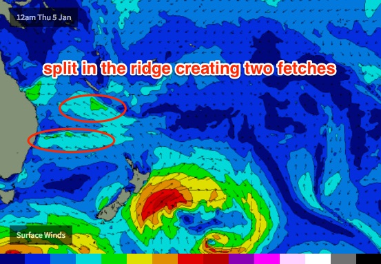
Although Monday’s forecast for the second half of this week was hardly stellar, the outlook has downgraded a little across some regions, over the last few days. This is due to the ridge across the Tasman Sea being somewhat split in half, with two seperate fetches - one aimed into Central NSW (Mid North Coast through the northern Hunter) and a second through the Coral Sea.
Whilst we’ll still see some E’ly swell from these sources, the broad spread will be less than the potential size if both fetches were not so heavily disjointed.

The biggest beneficiary under this synoptic pattern will be the Mid North Coast, which should see 2-3ft sets through Thursday and slightly larger waves on Friday, however we’ll see marginally smaller surf across the Far Northern NSW coast and also across SE Qld beaches. So, expect sets of around 2ft across exposed spots, and only small slow waves along the points.
The coastal trough across the Capricornia coast may now lie a little too far north to benefit the Sunshine Coast, as was suggested in Monday’s notes. As a result, the model guidance has eased surf size across this region for the next few days.
In any case, winds will be generally onshore out of the east and such weak swells won’t do any favours for any of the regional points.
So in general expect small, low quality surf to finish the week. We may see isolated periods of light variable winds but on the whole there’s really not a lot to get excited about.
This weekend (Jan 7th - Jan 8th)
A stationary high pressure system in the Tasman Sea will firm up this weekend as a broad trough of low pressure moves south through the Coral Sea. This is expected to strengthen the ridge between the two, and will consequently build easterly swells across the region.
Wave heights will be biggest in SE Qld, reaching 3-4ft on the Gold and Tweed Coasts by Sunday and up to 3-5ft across the Sunshine Coast open beaches (smaller on the points) but winds will remain out of the eastern quadrant so expect bumpy beaches for the most part. Surf size will be smaller through Saturday morning as wave heights begin an upwards trend.
The ridge will extend a reasonable distance down through the Tasman Sea so we’ll see plenty of E’ly swell through the remaining regions of the Northern NSW coast, with sets around 3ft+ all weekend. Light to moderate onshore winds are expected on Saturday but we may see variable periods on Sunday as a new ridge builds to the south (ahead of an afternoon nor’easter).
Also in the water on Sunday will be small long period S’ly swell, generated by a deep low traversing the waters south of the continent mid-week. It’s expected to possibly reach the lower Mid North Coast very late Saturday but will otherwise show at south swell magnets (south of Byron) throughout Sunday with very inconsistent 2-3ft sets. The E’ly swell will likely be more dominant, in both size and consistency.
Next week (Jan 9th onwards)
The models have weakened slightly on the Coral Sea’s progged tropical developments next week, which is a shame as it’s diluted the chances of a notable swell event.
However, all is not lost. The ridge will remain in pace through the start of next week which means we should see a steady supply of useful trade swell either side of 3ft (smaller to the south of about Ballina, bigger to the north) through until about the middle of the week.
Additionally, with the active monsoon trough still pushing across the Top End, we’re still looking at a couple of weeks of heightened tropical activity through the Coral Sea and South Pacific. Indeed, the models are showing some more action in the Coral Sea mid-next week which could lead to the development of a swell generating system mid-late next week - but as it’s right at the end of the model runs, we typically see these kinds of systems shunted back a day or so, every day. Which means that it could be some time until a significant system eventuates.
But as I mentioned last week.. all of the ingredients are certainly in place for some dynamic developments so let’s just wait and see how the models evolve over the coming days.


Comments
The Coral sea is proving to be a bit of a prick tease at the moment...
I don't even remember what a combination of good wind and swell feels like at this point. Literally half a year of SHITE.
I hear ya!! Winter was rubbish.spring shit and the summer is ticking by and haven't received anything yet.
This morning was the pick by far. Warm water. Super fun peaky glassy waves. Happy days.
Hey Don i send you a email a while ago. I thought you must off been busy.