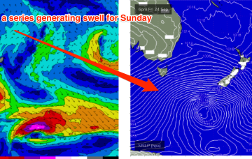
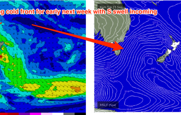
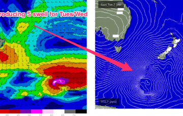
A deep low just to the SW of Tasmania with a strong front attached is expected to transit into the Tasman sea through tomorrow with gales adjacent to Tasmania generating a steep increase in S swell through the a’noon.
Primary tabs
/reports/forecaster-notes/eastern-tasmania/2021/09/24/plenty-action-the-s-then-ne-next-week
freeride76
Friday, 24 September 2021
/reports/forecaster-notes/eastern-tasmania/2021/09/22/s-swell-pulses-weekend-ne-windswell-next-week
freeride76
Wednesday, 22 September 2021
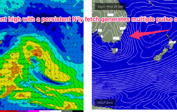
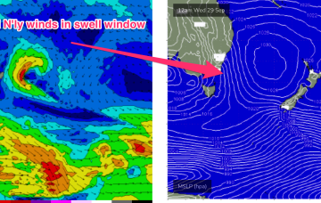
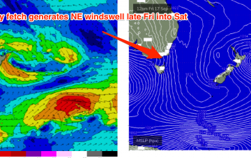
Pressure gradients tighten on Tuesday as a cut-off mid-latitude low in the Bight approaches, with N’ly winds starting to freshen along the NSW South Coast and adjacent waters. This N’ly fetch is expected to be a useful swell source for NETas.
/reports/forecaster-notes/eastern-tasmania/2021/09/20/wintry-week-embedded-s-swell-pulses
freeride76
Monday, 20 September 2021
A wintry pattern is on offer this week, with a stack of intense frontal activity impacting Tasmania and a deep, complex semi-stalled Polar low providing refracted S swell pulses through the week.
/reports/forecaster-notes/eastern-tasmania/2021/09/17/ne-windswell-easing-through-weekend-wintry
freeride76
Friday, 17 September 2021
A better angled fetch associated with a frontal fetch moving NE into the Tasman later Mon into Tuesday sees surf build into the 3ft range at S exposed spots with early SW winds from the front turning WNW as it passes by.

/reports/forecaster-notes/eastern-tasmania/2021/09/15/ne-windswell-frisat-brings-calm-period-end
freeride76
Wednesday, 15 September 2021
A large, twin centred high is now straddling Tasmania, bringing a regime of settled conditions, which will be brought to an end later this week as N’lies freshen along the Western flank of the high, generating useful NE windswell.
/reports/forecaster-notes/eastern-tasmania/2021/09/13/surf-easing-back-tinyflat-after-tomorrow-until
freeride76
Monday, 13 September 2021
High pressure straddling Tasmania brings a weak and variable wind flow through the week up to Fri, with tiny surf expected and settled conditions.
/reports/forecaster-notes/eastern-tasmania/2021/09/10/s-swell-mon-easing-surf-and-better-winds
freeride76
Friday, 10 September 2021
This deep S’ly fetch is expected to see wave heights build through Mon but conditions aren’t expected to be great with a strong high pressure ridge building in the wake of the front and mod S to SE winds expected.
/reports/forecaster-notes/eastern-tasmania/2021/09/08/tiny-weekend-ahead-s-swell-monday
freeride76
Wednesday, 8 September 2021
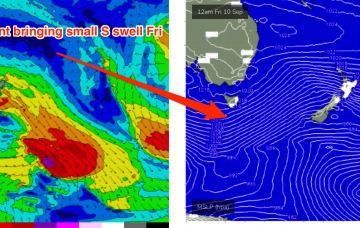
This front is expected to be a swell producer for the NE Coast with a deep S’ly fetch tied to a complex low tracking NE through Mon and bringing a steep increase in new S swell through the day. Unfortunately this will come with S’ly through SSE’ly winds so you’ll need to find somewhere out of the wind to surf and sacrifice some size.
/reports/forecaster-notes/eastern-tasmania/2021/09/06/more-s-swell-incoming-winter-strength-fronts
freeride76
Monday, 6 September 2021
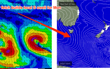
This swell will be generated by a deep low centred around 50S which is expected to track south of Tasmania later tonight, with a slight NE wobble as it transits the Tasman on Tuesday. This is a powerful storm, with storm force winds and a large area of seas in excess of 30ft.
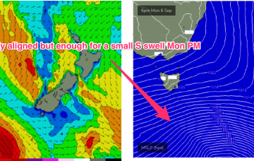
/reports/forecaster-notes/eastern-tasmania/2021/09/03/easing-ne-swell-sat-small-s-swells-next-week
freeride76
Friday, 3 September 2021
Models have rejigged the frontal progression into the Lower Tasman next week with a less favourably aligned storm track for NETas.