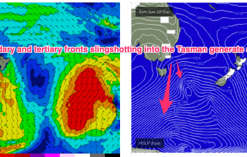
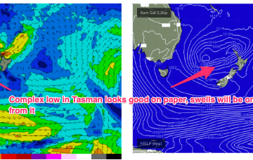
A front and small low are now racing across the Tasman with a high over NSW moving into the Tasman and directing a freshening N’ly flow across most of the Eastern Seaboard and a developing tradewind flow. So far, so spring. A complex low, front and trough then approaches from the W, bringing a flush of W’ly winds and a S swell.
Primary tabs
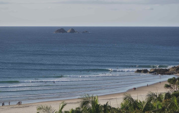
/reports/forecaster-notes/south-east-queensland-northern-new-south-wales/2023/09/06/few-workable
freeride76
Wednesday, 6 September 2023
/reports/forecaster-notes/south-east-queensland-northern-new-south-wales/2023/09/04/plenty-wind
freeride76
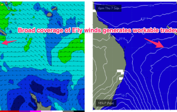
Monday, 4 September 2023
E’ly tradewinds look to develop through the Coral Sea later this week bringing workable E/NE swells.
/reports/forecaster-notes/south-east-queensland-northern-new-south-wales/2023/09/01/few-small-options
freeride76
Friday, 1 September 2023
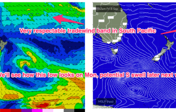
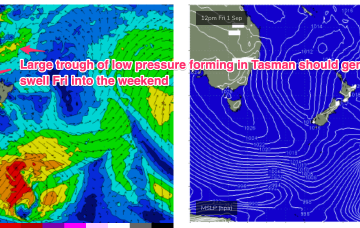
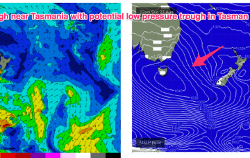
No great change to the weekend f/cast. S swells will be the dominant force in the water through tomorrow, mostly mid period stuff whipped up by a proximate fetch of S-SSW winds generated by a front and trough of low pressure forming in the Tasman.
/reports/forecaster-notes/south-east-queensland-northern-new-south-wales/2023/08/30/minor-downgrade
freeride76
Wednesday, 30 August 2023
This trough then absorbs another trough of low pressure moving south from the South Pacific islands to form a large area of low pressure near New Zealand. Compared to Mondays notes the components of this complex pattern all look a little weaker and more mobile with reduced swell generating potential, but we will still see some useful pulses from the various incarnations of the broad pattern.
/reports/forecaster-notes/south-east-queensland-northern-new-south-wales/2023/08/28/surf-the-e-ands-s
freeride76
Monday, 28 August 2023
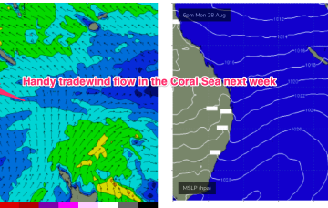
The trough is expected to move offshore and merge with a more tropical derived depression to form a large trough of low pressure in the Tasman over the weekend. This has been a feature of synoptic prognostic charts for a few weeks now, with forecasts generally tending to weaken and fall apart as the event unfolds.
/reports/forecaster-notes/south-east-queensland-northern-new-south-wales/2023/08/25/small-swells-and
freeride76
Friday, 25 August 2023
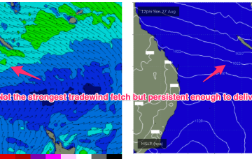
We’ve still got the basic building blocks in place that we mentioned on Wed with the proviso that everything looks a little weaker and disjointed. High pressure moves NE of Tasmania and the troughs remain inland, although we may see a weaker trough area move off the North Coast of NSW early in the week. SE-E/SE tradewinds are established in the Central Coral Sea and will supply small tradewind swell for the first half of the week at least.
/reports/forecaster-notes/south-east-queensland-northern-new-south-wales/2023/08/23/remaining-small
freeride76
Wednesday, 23 August 2023
A cold front and long trough are bringing a S’ly change to the NSW coast, extending into the sub-tropics later today and overnight. There’s not a great deal of useful swell generating winds associated with the change so only modest short range S swells are expected to accompany it. The lingering troughy pattern gets much more dynamic over the weekend (and next week) as a powerful high approaches from the Bight.
/reports/forecaster-notes/south-east-queensland-northern-new-south-wales/2023/08/21/small-surf-week
freeride76
Monday, 21 August 2023
The remnants of the weekends frontal systems have set up a fading off axis fetch near New Zealand with the current run of small S swells also on the way out. A weak mid week front will bring a wind change and a small flush of S swell but next week looks a bit more robust although with plenty of wind.
/reports/forecaster-notes/south-east-queensland-northern-new-south-wales/2023/08/18/stiff-august
freeride76
Friday, 18 August 2023
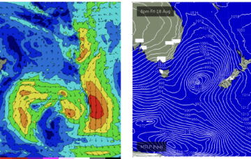
Sunday looks better, for size at least. The head of the fetch reaches almost to New Caledonia and this typically aids S swell penetration into SEQLD.
/reports/forecaster-notes/south-east-queensland-northern-new-south-wales/2023/08/16/brief-tricky
thermalben
Wednesday, 16 August 2023
Easing swells are expected for the rest of the week, and northerlies will give it a kick in the pants on Thursday afternoon.