Mooloolah River Entrance Wave Dredged
Users of Mooloolaba Harbour have been promised the removal of sand currently settling at the entrance to the Mooloolah River on the Sunshine Coast. For surfers, however, the sand has created a dependable bank in east and north swells, and ridden as an extension of Point Cartwright.
The new bank traces the historical outline of the old rivermouth wave, which was destroyed when breakwalls were built in 1965 to train the river and create the harbour. Prior to that, a regular sand bank built up, fanning from the tip of Point Cartwright to where the Mooloolaba Surf Club now stands. Period photos show a straight-edged bank that, though semi-sheltered from swell, had fantastic potential.

The entrance to the Mooloolah River in the early 1960s prior to construction of the river breakwalls
Since the breakwalls went in, Mooloolaba Harbour became a designated state harbour: each one placed about a day's sail apart on busy coastlines and used for recreation and safety. Mooloolaba Harbour is now home to a fishing fleet, recreational craft, and also hosts occasional yacht regattas. To manage the marine traffic, the entrance to the harbour has to be intermittently dredged to maintain depth.
The last time the entrance was significantly dredged was 2017, however sand began building up again and by 2019 the bank was again shallow enough to surf on lower tides and larger swells.
Back to back la Nina events accelerated sand accretion, and last season, when relentless east and northeast trade swells impacted the Sunshine Coast, the bank significantly grew in length and reduced in depth. By May, the bank could be surfed right around the tide, offering a long running wall.
The size and depth of the bank has adversely affected marine traffic with a string of crossing incidents occurring. On April 12th, the prawn trawler Canipa struck the bank while crossing the bar near high tide. Loaded with four tonnes of king prawns and 20,000 litres of fuel, skipper Peter Bellamy wrenched the boat free and turned back out to sea. He's since set up port elsewhere.
Mooloolah River Fisheries also claim to have been financially struck by the errant sand as boats dock elsewhere to unload or buy fuel, usually sailing further south to Brisbane.
More recently, a surfer was literally struck when a boat from Mooloolaba Volunteer Coastguard, rather than navigating around the bank, crossed through the waves. One of the surfers had to ditch their board and dive underwater to avoid the oncoming vessel. The surfer dived deep enough to avoid the propeller, but their surfboard was run over in the process.

Depth chart for the Mooloolaba Harbour entrance
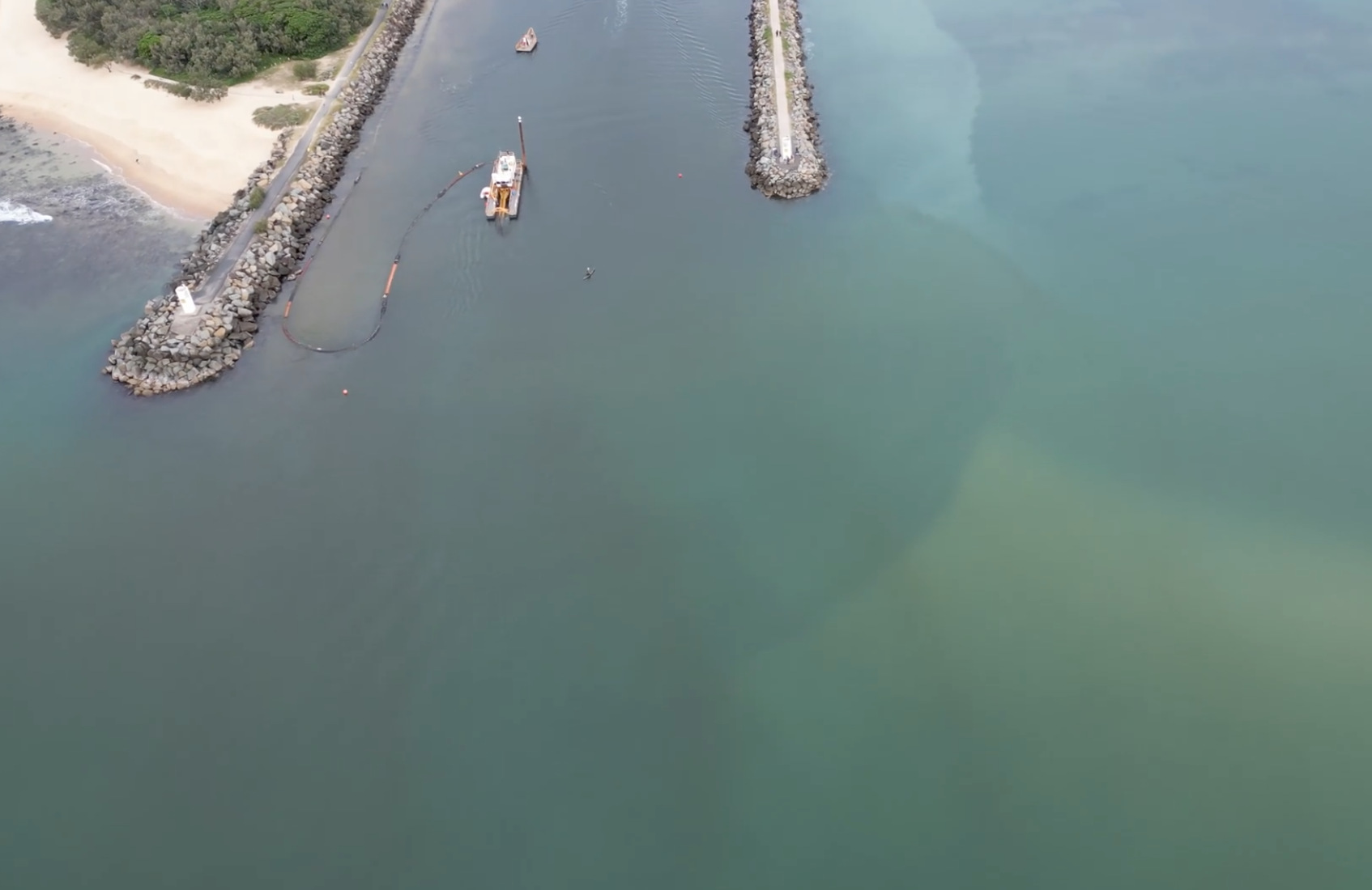
Local users have been asking for dredging works but to date only a small dredge working inside the harbour entrance has been able to operate. This work makes little difference to the outside sandbank which is largely comprised of marine sand from the longshore drift. Despite Marine Safety Queensland promising to begin dredge work on the bank since February, the active surf season halted every available window.
"We're acutely aware of the shoaling at the entrance of the Mooloolah River," MSQ general manager Kell Dillon told the ABC in May. "The high swell and increased wave action along the coast has made that particularly dangerous for mariners but also for the dredge."
Mr Dillon also told the ABC a larger dredge, the Port Frederick, which was currently at anchor in Moreton Bay, would shortly be brought north to complete the outside dredging work, however work has yet to begin.
A spokesperson from Mooloolaba Coastguard said that when work begins, surfers will be advised to keep clear of the zone, yet also noted there was no power to remove them while the dredge wasn't operating. Once it begins, the work could take up to six months, weather permitting, and when complete will spell the end of the wave.
And it may be for good, as boat users, buoyed by local Member for Maroochydore Fiona Simpson, campaign for a sixty metre extension to the eastern breakwall. If constructed, it would block all sandflow and almost certainly spell the end of the intermittent wave.


Comments
Calmer waters: harbour entrance is safe for now but a permanent solution is called for.

https://www.sunshinecoastnews.com.au/2022/06/10/mooloolaba-harbour-entra...
Surfing!
The sport is a disease!
Love the old pic. So much sand at Cotton Tree. The M'dore river mouth is so far north. And all the coffee rock appears to be exposed along Pipes and Sharks.
How good does that original bank/wave look?
we could have a super banks over here. fucking humans
I've had some of the best tow and paddle foil sessions there the last couple months!! Like that pic shows its been unreal!! I knew it couldn't last forever, but geez it was good while it lasted!!
Perfect location for bullsharks and surfers to meet
Straight offshore in SE winds, open to swell from E to NE.
Paradise.
River mouth looks like a right hand version of Merimbula
Except you don't have to paddle across a sharky feeling river to get to and from the bank
Except they didn't pave this one, nor put up a parking lot, just built two fuck off breakwalls.
Great in a big SE swell too. I don't remember it (too young) but my dad said the waves at Cartwright/Mooloolaba in the early 60s before they built the breakwater were so good in a cyclone/low and so well protected from the wind that many SC surfers preferred to surf there rather than to head up to Noosa - quite a accolade when you consider Nationals when it's working is one of Australia's greatest waves.
No option to put the breakwall through the sand dune on the southern side? Then access for boaties and the break stays untouched?
Reckon that prawn trailer has sailed, mate. Anyway, the thing that makes those period shots so delightful is the triangular bank; a classic rivermouth set up shaped in part by tidal flow, wave action, and sand flow. If the river flowed out the south side there'd be no tidal action and limited sand flow - as it would be caught behind the breakwalls.
If you look at a birds eye view of the point as of last week (before they started dredging) you would see the sand bank has built up in the exact same way as those old photos, no stopping mother nature no matter how hard we try!!
The good lord loves a righteous sandbar. As do I.
Damn, they are gorgeous things. Unfortunately my local one has developed a dirty big hole right in the middle, after not changing at all since September. I remain sanguine and hopeful that it will return to its former glory.
Anyone know what happened at Urbnsurf?
Na I saw they'd closed. What happened ?
Sounds like a bloke in his 40s suffered a heart attack whilst surfing. Some reports suggested there might have also been a head injury as a result. He was taken to hospital unfortunately in a critical condition. There's been very little reporting since Friday last week when it happened. Hopefully a good outcome from here for the fella involved.
Looks lIke a classic little 60's set up there. Once you fuck with something you have to keep fuckin with it to keep everyone happy. Progress?
The 60 metre extension sounds like a bad idea -https://www.fionasimpson.com.au/fix-mooloolaba-harbour-entrance/ There is also a link to the response to Simpson's question in parliament - https://documents.parliament.qld.gov.au/tableoffice/questionsanswers/202...
So sad looked like such a fun set up pre groyne
Eastern wall extension would spell the end of the inside bank but could vastly improve the Turtles, Platform and Carties waves. Surely that would trap a heap of sand. Maybe it becomes one long wave instead of a series of sections. Sadly, we’ll never know the quality of what might have been with no walls.
Also, I think sometime last century the river did break through the eastern beach for a time briefly. Not sure of the details. Hypothetically, if there were walls out from the Kawana side with dredging we could have a DBah style beach up to the pocket and a Superbank on the north side through to Mooloolaba beach.
Both Caloundra and Mooloolaba had fishing fleets prior to the breakwalls being built; in fact it was a toss up between the two as to which would have it's bar stabilised by walls. Mooloolaba got the nod probably because the Mooloola River mouth was more north facing and provided greater protection from SE swell and weather events. Caloundra's fleet and associated commercial fishing industries gradually then shut down or migrated up Mooloolaba.
Could have a world classish wave there with safe passage for boats if the right mods and people with clout came together.
Back in the 90s they had a dredge pipe pumping sand up from the surf club and made the most perfect bank. Barrels that'd match any sand bottom beach break!!
Now I'm in the deep south, I've had similar thoughts on what Portland, Port Fairy and Warrnambool must've been like back before the ports. Incredible set ups. Such is life
Add in Apollo Bay/Marengo to that...
Nature is a sculptor and not a boatie.
Mooloolah River Breakwall recent News Timeline...
2013/14/16 Sand issues > Courier Mail cites #1 Surf Journo Stu...@ swellnet
June 2017 Big Swell
https://www.facebook.com/mooloolabamarina/photos/439474699753842
https://www.facebook.com/mooloolabamarina/photos/439474679753844
2017 Surfers (vs) Boaties > Courier Mail
Maritime safety report > Depth 0.3m (April 2017 : Dredge Booking)
Nov 2021 Surfrider Foundation learn of > Breakwall Extension!
Scroll to end comment...
https://www.swellnet.com/news/swellnet-analysis/2016/07/27/scientists-ex...
13th June 2022 Low Tide Lineup Vid
https://www.facebook.com/coastguardmooloolabaQF6/videos/329638232658901/
16th June 2022 Hydrographic Survey
https://www.facebook.com/coastguardmooloolabaQF6/photos/a.16335347569270...
Click see more...in [f] comments.
17th June - After 3 weeks (Cutter suction dredge Navua) ceased operations until further notice!
Thanks TBB for info.
Photo from Facebook, taken before the dredging:
Uncle used to body surf that top pic in article up to double overhead in the 1940s. We lost him a couple of days ago, the old family are missed and their stories are passed on, what a place it was.
Qldurrz thank the epic sharing from stunet & velocityjohnno...sad to hear about your uncle.
Sounds like he lived the life...feel free to share more...
Your uncle's pioneering big wave exploits will certainly ramp up Qld bodysurfing History!
tbb is making note of your invaluable share...stoked!
See! It's rare to talk about early big wave bodysurfing outside of incidental Cyclonic sessions!
Extends the timeline of Local Big Surfing of all kind...so cool!
Sends shivers up & down yer spine at that size...Qld bodysurfers salute!
https://www.sunshinecoastnews.com.au/2023/08/14/trial-to-safeguard-hazar...
A trial to improve a high-risk harbour entrance has yielded some promising results.