/reports/forecaster-notes/south-east-queensland-northern-new-south-wales/2015/11/23/south-swells
thermalben
Monday, 23 November 2015
This is still early days, and November is not an ideal month for positive speculation across Southeast Queensland.
/reports/forecaster-notes/south-east-queensland-northern-new-south-wales/2015/11/20/lots-south-swell
thermalben
Friday, 20 November 2015
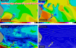
The long and short is that there’s plenty of south swell due from Monday right through until next Sunday - almost a week of of persistent energy from the southern quadrant.
/reports/forecaster-notes/south-east-queensland-northern-new-south-wales/2015/11/18/desperate-times
thermalben
Wednesday, 18 November 2015
The models have moved around quite a bit over the last few days, and the weekend outlook has changed considerably.
/reports/forecaster-notes/south-east-queensland-northern-new-south-wales/2015/11/16/fun-surf-tuesday
thermalben
Monday, 16 November 2015
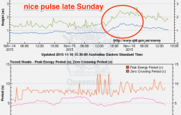
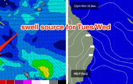
A trough in the Northern Tasman Sea is working in conjunction with an advancing high pressure system in the southwest, to maintain a fresh SE fetch through the central Tasman. This is generating a new SE swell that’s due to arrive this evening, before easing in size throughout Tuesday.
/reports/forecaster-notes/south-east-queensland-northern-new-south-wales/2015/11/13/fun-sunmon-much
thermalben
Friday, 13 November 2015
I reckon we’ve got some really nice waves on the way for the first half of next week.
/reports/forecaster-notes/south-east-queensland-northern-new-south-wales/2015/11/11/small-uninspiring
thermalben
Wednesday, 11 November 2015
No major changes for the rest of the week.
/reports/forecaster-notes/south-east-queensland-northern-new-south-wales/2015/11/09/small-small-small
thermalben
Monday, 9 November 2015
Nothing major throughout the forecast period.
/reports/forecaster-notes/south-east-queensland-northern-new-south-wales/2015/11/06/small-window
thermalben
Friday, 6 November 2015
It’s really not a great forecast period for Southern Queensland and Northern NSW surfers.
/reports/forecaster-notes/south-east-queensland-northern-new-south-wales/2015/11/04/dreary-outlook
thermalben
Wednesday, 4 November 2015
Lots happening on the charts this week, but not necessarily much in the surf department.
/reports/forecaster-notes/south-east-queensland-northern-new-south-wales/2015/11/02/wednesday-pick
thermalben
Monday, 2 November 2015
There are numerous regions that have already developed, are developing or are yet-to develop, all of which will contribute energy over the coming days.


