Slow end to the week, options on the weekend then windy and stormy next week
South Australian Surf Forecast by Craig Brokensha (issued Wednesday May 25th)
Best Days: Mid Coast for the keen Friday morning, Saturday morning South Coast, Sunday morning South Coast, Wednesday South Coast
Features of the Forecast (tl;dr)
- Tiny W/SW swell tomorrow and Fri with W/SW tending SW winds tomorrow on the Mid, variable tending W winds Fri
- Inconsistent mid-period SW swell building Fri PM, with a better pulse Sat, easing Sun
- NW tending W/SW winds Sat, strengthening N Sun
- Building mix of low quality SW and S/SW swells Mon with strong W/SW tending SW winds Mon, strong S/SW Tue
- Easing S/SW swell Wed with W/NW winds
Recap
Tiny clean surf down South, ideal for bigger boards with tiny wind affected waves on the Mid Coast.
This week and weekend (May 26 – Jun 3)
The end of the week looks average with no new significant swell due tomorrow down South, while a weak windswell looks to develop on the Mid Coast with 1-1.5ft sets due tomorrow and Friday. Winds will be onshore and moderate to sometimes fresh tomorrow, W/SW tending SW with variable offshore winds Friday morning, fun on the right equipment.
The South Coast will be tiny with a W/NW breeze tomorrow morning and NW winds Friday morning with fresher W/SW breezes into the afternoon.
 A new, mid-period SW swell is due into Friday afternoon, with a secondary better pulse Saturday generated by a patchy though broad polar low that fired up around the Heard Island region on the weekend before slowly pushing east.
Size wise, Middleton should come in at 2-3ft while the Mid Coast will see some localised windswell and mid-period energy continuing around 1-1.5ft. Winds will freshen from the NW Saturday morning, favouring the South Coast ahead of a W/SW change as a broad, cold, strong low pushes up and across the state.
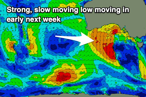
This low is quite a tricky system with it not being favourably aligned for quality swell production, instead projecting a fetch of strong to gale-force S/SW-SW winds up and across us.
Ahead of the low we should see N'ly winds, strengthening with easing levels of swell from 2-3ft across Middleton and tiny waves on the Mid Coast.
The low will move across us proper on Monday bringing an increase in mid-period, windswelly and stormy waves with no major size or quality. It looks like Middleton will kick to the 4-5ft range Monday afternoon with W/NW tending SW winds, strong S/SW on Tuesday and a similar size. The Mid Coast should come in around 3ft but with no quality.
We'll see a weak front moving in on Wednesday bringing better W/NW winds, but we'll review this on Friday. Swell wise, easing S/SW sets from 4ft are due across Middleton, 2-3ft on the Mid Coast.
Longer term a stronger and better looking frontal progression may generate some better swell late next week but with winds from the western quadrant. More on this Friday.


Comments
Hey Craig, looking at running our club comp Saturday at knights. What time should we expect the wsw change and how strong will it be?
Hey Jasper, GFS is stalling it so no real change until later but EC has it around midday. Will see what EC has for this evening.
EC has updated and is in line with GFS, change more so mid-afternoon.
Cheers Craig, that’s good news, fingers crossed it’s later rather than sooner. Keep up the good work mate. I actually took a screenshot at nearly the same time as that knights shot!! Crazy colours
Dynamic!
Hey mate forcast changed this morning flat saturday, when is that swell expected? Saturday now not worth it? cheers
Temporary glitch in the matrix, should be updated soon.
haha ah was hoping so, been trying to run our event for about 2 months now so we all a bit on edge haha