Tricky period of weak swells and varying winds

Victorian Forecast by Craig Brokensha (issued Monday December 23rd)
Best Days: Exposed beaches mid-morning onwards ahead of sea breezes Wednesday, exposed beaches Thursday, Surf Coast Sunday morning, exposed beaches Monday morning
Features of the Forecast (tl;dr)
- Small-mod sized low quality swell for tomorrow AM, easing
- Fresh W/SW tending stronger S/SW winds (lighter W/NW early Surf Coast)
- Easing swell Wed with variable winds, tending locally offshore ahead of fresh SE sea breezes
- Small background swell Thu with strong N/NE winds, easing later PM ahead of a strong SW change
- Weak mix of swells Fri with strong W/NW tending W/SW winds
- Weak mix of swells Sat with gusty W/NW tending S/SW winds
- Better mid-period W/SW swell Sun, easing slowly Mon
- N/NW tending W/NW then S/SW winds late AM Sun
- Variable tending NE winds Mon with a strong SW change Tue
Recap
The weekend was poor all around with strong onshore winds Saturday, easing a little yesterday but with small levels of swell.
Today has come in a little cleaner but only 2ft+ or so on the Surf Coast with our new mid-period swell due into this afternoon but with strong SW winds.
This week and weekend (Dec 24 - 29)
We’ve got a progression of healthy but relatively weak frontal systems moving up and into us, with a peak in size due later today, early tomorrow across the Surf Coast mostly to 3ft with the odd 4ft’er possible across the magnets. It’ll be weak, low quality stuff and with a fresh W/SW-SW breeze that will likely be lighter W’ly for a period on the Surf Coast.
Wednesday still looks the best of it though across the exposed beaches across the state with easing levels of mid-period energy from 2ft or so on the Surf Coast and 3-4ft to the east under a variable breeze, tending light, locally offshore during the morning.
There’ll likely be some surface lump at dawn from overnight onshores, improving as the morning goes on before sea breezes kick in from the SE early afternoon.
Thursday looks windy but clean across the exposed beaches with a strong N/NE breeze and background W/SW swell to 3ft to occasionally 4ft on the sets, small to tiny on the Surf Coast. Winds are due to back off later afternoon ahead of a strong, cool S/SW change into the evening.
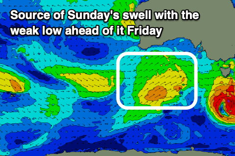
Now, this change was expected to be associated with a deepening mid-latitude low moving in from South Australia, bringing a moderate sized increase in swell for the weekend, but it’s been downgraded significantly resulting in more weak levels of mid-period energy from the W/SW from Friday through Sunday.
Instead, persistent but tricky to nail down pulses of W/SW swell will continue but best into Sunday/Monday.
Friday and Saturday’s pulses look very average and weak, likely not topping 2ft on the Surf Coast with 4ft waves to the east, but come Sunday we should see a bit better energy in the water to 2-3ft on the Surf Coast, generated by a broader fetch of strong W/SW winds moving under the country later in the week.
Winds will favour the Surf Coast and be W/NW tending S/SW both Friday and Saturday, with Sunday seeing early N/NW winds, shifting W/NW ahead of strong S/SW breezes into the afternoon.
A slow drop in size is due early next week with lighter, offshore winds for the beaches to the east Monday morning, while another strong SW change is likely shortly after dawn Tuesday. We’ll likely see some better swell later week but we’ll look at this again on Christmas Day.
Comments
Merry Christmas Craigos and SN crew! Enjoy ya first with your little one mate
Cheers Dx3, you too!