Indonesia/Maldives forecast Dec 19
Indian Ocean Basin analysis by Craig Brokensha (issued Thursday 19th December)
This week through next (Dec 20 - 27)
Our large swell delivered the last couple of days across the region, but strong westerly winds limited the best options to more sheltered spots.
Today the swell is on the ease, with it dropping further tomorrow ahead of our mix of long-range SW groundswells Saturday, peaking later, easing slowly Sunday.
These were generated by a great frontal progression trailing the strong low linked to the last two day’s swell, though size wise it looks to come in a little under what we’ve seen.
An easing trend should continue into Monday/Tuesday ahead of a long-range, inconsistent SW groundswell Tuesday afternoon, easing Wednesday.
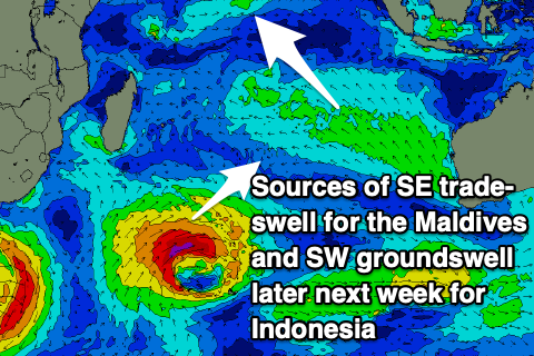
This was generated by a distant low to the south-east of South Africa and the models are incorrectly combining existing mid-period energy, over-forecasting the size and missing the peak.
Later Tuesday will likely see the most size and consistency before easing Wednesday.

Into the end of the week, another good mix of moderate to large SW groundswells are due, produced by a great frontal progression moving from under South Africa, right across the Indian Ocean Basin.
The low is currently at its peak strength and intensity but will broaden while weakening slowly and moving east, but we should see the groundswell arriving Thursday afternoon, peaking Friday.
The strong monsoonal winds should start to abate through early-mid next week, lighter into the end of the week and more variable next weekend.
The Mentawai and Sumatran regions will continue to see winds persist out of the NW this period, stronger early-mid next week as a monsoonal surge moves through, easing later week but swinging more W.
----------------------------------------------
Maldives: A small pulse of inconsistent S’ly groundswell is due into tomorrow, but later Saturday a stronger pulse of energy is due, generated by a strong low that formed under South Africa earlier this week.
A small-moderate sized pulse is expected Sunday before easing Monday.
There’s been no change to the SE trade-swell due into the weekend, with the swell generating fetch due to ease from here on in, resulting in a slow downwards trend through next week.
Following this, the strong Southern Ocean frontal progression that’s currently beginning to the south of South Africa should produce a moderate sized pulse of S’ly groundswell for next Tuesday, likely peaking into the afternoon/evening and then easing slowly Wednesday from a similar size.
Our strong to gale-force W-W/SW wind surge for the coming days is on track, slowly abating from Sunday while tending W/NW, becoming lighter W/NW-NW next week.
Eastern Indonesia:
Easing mix of swells tomorrow.
Mod-large, inconsistent SW groundswell filling in Saturday to 6ft+, easing slowly Sunday.
Moderate sized, inconsistent SW groundswell for Tuesday afternoon/evening to 4-6ft, easing slowly Wednesday from a similar size.
Mod-large mix of SW groundswells building Thursday, peaking Friday to 6ft+ across exposed breaks, easing into the weekend.
Strong W/NW-W/SW winds, abating slowly next week and variable next weekend.
Uluwatu 16-day Forecast Graph/WAMs
Western Indonesia/Mentawais/South Sumatra:
Easing surf tomorrow.
Moderate + sized S/SW groundswell for Saturday to 6ft, easing Sunday.
Moderate + sized, inconsistent SW groundswell Tuesday to 5-6ft, easing Wednesday.
Weak, moderate sized W swell for Tuesday, easing Wednesday.
Mod-large S/SW groundswell for next Thursday to 6ft+, easing Friday.
Gusty NW winds, lighter to the north with stronger winds early-mid next week, easing and tending more W’ly later week.
Mentawai 16-day Forecast Graph/WAMs
Maldives:
Small, inconsistent S’ly groundswell tomorrow, easing over the weekend.
New SE trade-swell on Saturday/Sunday to 3-4ft, easing very slowly next week.
Small-moderate sized S’ly groundswell building later Saturday, peaking Sunday to 3-4ft, easing next week.
Moderate sized S’ly groundswell for next Tuesday, reaching 4ft+ across the southern atolls, easing slowly Wednesday.
Strong to gale-force W winds tomorrow and Saturday, easing slowly from Sunday while tending more W/NW.
Lighter W/NW-NW winds developing next week.


Comments
Latest notes are live.
Cheers Craig , seen some beautiful footage of east coast , I’ve got daddy day care duties and neat little hole in arm which is healing up nicely. Missed this swell but had a fantastic year , thanks again for these reports . Merry Xmas and all the best to Swellnet team in the new year .
Indian Ocean just keeps giving
Cheer for the updated indo forecast, I'm in Simeulue atm the swells for Tues and Thurs roll through up here !
Has been 0-4 knotts of wind all day everyday so perfect conditions.