Great W/SW swells this week and weekend
South Australian Forecast by Craig Brokensha (issued Monday 1st May)
Best Days: Mid Coast Tuesday and early Wednesday, South Coast Thursday and early Friday, Sunday Mid Coast
Recap
Small clean fun waves across magnets on the South Coast Saturday morning, with a new increase in swell through the afternoon with workable SW winds. The Mid Coast was tiny and lumpy.
Sunday was excellent down South with a peak in S/SW groundswell and light offshore winds but surfing options were limited. The Mid Coast saw bumpy 1-1.5ft sets.
Today the surf was much smaller but nice and clean on the South Coast early with an offshore wind, but a gusty onshore change has since moved through.
This week (May 2 – May 5)
Today's onshore change is linked to a weakening mid-latitude low passing across us, and with it we'll see a new mix of W/SW groundswell and mid-period S/SW swells developing across the state tomorrow.
The W/SW groundswell was generated over the weekend by the early stages of the mid-latitude low, with a fetch of gale to severe-gale W/SW winds projected through our western swell window.
The swell from this low has come in at a clean 6-8ft across Margaret River and should fill in tomorrow across our state, coming in at 2ft+ across the Mid Coast, with 3ft bombs likely on the incoming tide.
The South Coast should be coming in around 3-4ft, but with fresh SW tending S/SW winds. The Mid Coast is looking bumpy with a lighter S'ly wind likely early, tending S/SW through the day and back to the S/SE into the evening.
A drop in swell is due Wednesday from 2ft on the Mid Coast, while the South Coast will see some new S/SW swell from a polar front projecting up towards Victoria through our southern swell window.
It won't be the strongest swell with mid-period 3-5ft sets due off Middleton, easing later and further Thursday from 2-3ft.
Conditions should slowly improve, with light E/SE winds Wednesday morning, while Thursday morning is the pick with a light N/NE offshore, tending variable into the afternoon. Friday will be clean again but the swell small and fading from 2ft off Middleton (not much bigger at Waits with the southerly direction).
This weekend onwards (May 6 onwards)
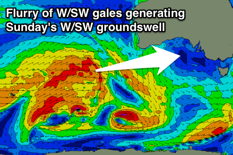
 As touched on last update, we're due to see a strong W/SW groundswell this weekend, generated by a vigorous storm firing up in the south-east Indian Ocean.
A strong and slow moving polar frontal progression will form in the Heard Island region this afternoon and evening, projecting a flurry of gale to severe-gale W/SW winds through our western swell window while projecting towards and under the country over the coming week.
One of the final fronts in the progression will push into us on Saturday, bringing a strong onshore S/SW change and increase in S/SW windswell ahead of a the W/SW groundswell proper Sunday.
Looking at the expected size on Sunday and the Mid Coast is expected to offer 2-3ft sets, while the South Coast looks to come in at 3-5ft or so. It looks like we'll see morning S/SE winds Sunday favouring the Mid, but if the front moving through Saturday slows any more, this could change to S/SW. So lets look at this again Wednesday.


Comments
Nice conditions on the Mid this morning..