Good E/SE swell but with onshore winds

Eastern Tasmania Surf Forecast by Guy Dixon (issued Monday 14th March)
Best Days: Northern corners Thursday morning, Friday morning
Recap:
Good clean easing E'ly swell from 2-3ft Saturday, much smaller Sunday, while today a S'ly change has moved through with a weak building windswell.
This week (Tuesday 15th - Friday 18th):
A fresh southerly breeze has been blowing along the east coast of Tasmania throughout the day following the passage of one of the more vigorous fronts of this season. As a result, a small southerly windswell has been increasing and is due to peak this afternoon at around 2-3ft.
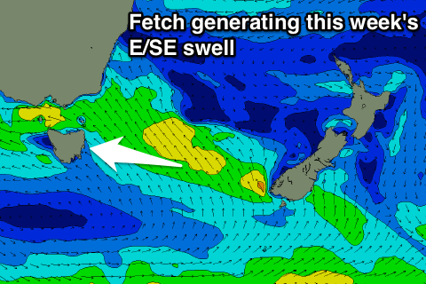 As a ridge builds in the wake of this front, this southerly fetch will progressively tend more southeasterly, spanning from the southern tip of New Zealand’s South Island to the South Coast of NSW.
Although the alignment of this moderate airflow is not quite ideal during its initial stages, we should continue to see options in the 2-3ft range from the southeast on Tuesday, with prospects of more size in the days to come as the alignment of this fetch improves.
Wednesday should see a slight increase in size with options in the 3ft+ range for most of the day, holding at a similar size on Thursday morning before easing thereafter.
By this stage, the local airflow should have swung northerly and looks to increase ahead of an approaching front. Although the duration of this fetch looks to be brief, a northeasterly windswell should still increase to a peak of around 2-3ft on Friday morning, however lacking power and easing rapidly thereafter.
Meanwhile, long range east/northeasterly trade energy should provide a subtle but steady stream of options in the 1-2ft range for the open beaches each day.
The wind outlook doesn’t look to great in the short term, with a persistent southeasterly breeze limiting options to the protected southern corners on Tuesday. Wednesday should see breezes slowly tend northeasterly, further around to the north/northeast by Thursday.
By Friday morning however, the southern extension of the northerly fetch should have pushed offshore, allowing for breezes to tend northwesterly, leading to groomed conditions for the first time this week.
This weekend (Saturday 19th - Sunday 20th):
As the aforementioned front passes overhead, Tasmania will once again be under a post-frontal regime, with southwesterly breezes whipping up a small amount of southerly energy to the 2ft range on Saturday, with quality lacking.
More detail on Wednesday.