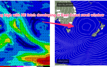
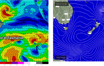
The slowed movement and enlargement of the wind field as it approaches the North Island are on track to deliver more powerful long period E-E/NE swell, not ideally aimed for Tasmania but with enough strength to deliver some 3-4ft sets through Mon and Tues.
Primary tabs
/reports/forecaster-notes/eastern-tasmania/2022/01/14/long-period-pulsey-swell-ex-tc-cody-incoming
freeride76
Friday, 14 January 2022
/reports/forecaster-notes/eastern-tasmania/2022/01/12/swells-the-e-and-ene-near-and-far-range-sources
freeride76
Wednesday, 12 January 2022
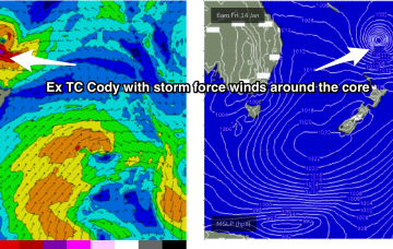
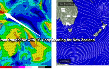
In the tropics TC Cody is drifting south through the South Pacific window , spraying the NSW/QLD coast with swell. The fetch is not well aimed for NETas but radial spread from the source should see some inconsistent 3-4ft sets through Mon, into Tues with winds much better on Mon.
/reports/forecaster-notes/eastern-tasmania/2022/01/10/few-small-weak-days-ahead-surf-builds-the-e-and
freeride76
Monday, 10 January 2022
The GFS scenario sees NE winds developing in the swell window Thurs with surf building into the 3ft range. A much bigger NE swell builds Fri into the 5-6ft range. With fresh NE winds.
/reports/forecaster-notes/eastern-tasmania/2022/01/07/easing-surf-over-the-weekend-very-quiet-period
freeride76
Friday, 7 January 2022
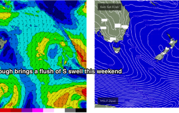
The rest of next week looks uneventful for the East Coast. A weak trough brings a slight bump in S swell Tues but its short period, weak stuff and unlikely to exceed 1-2ft.
/reports/forecaster-notes/eastern-tasmania/2022/01/05/large-stormy-ne-swell-incoming-end-the-week
freeride76
Wednesday, 5 January 2022
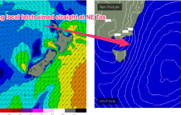
This fetch gets super-charged off Bass Strait and adjacent to the east coast of Tasmania by an interior trough, with E to E/NE gales expected to develop off the Gippsland coast later tomorrow (see below).
/reports/forecaster-notes/eastern-tasmania/2022/01/03/strong-swells-the-ene-week-plenty-onshore-wind
freeride76
Monday, 3 January 2022
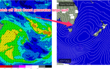
A second, much stronger swell from the E/NE to NE quickly follows as a dominant high slips under the state and quickly has a pressure gradient squeeze from an inland trough and the remnants of ex TC Seth.
/reports/forecaster-notes/eastern-tasmania/2021/12/31/ene-groundswell-the-way-tropical-low-drifts
freeride76
Friday, 31 December 2021
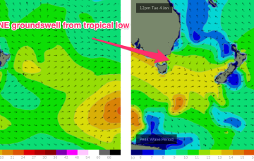
An intense sub-tropical low is expected to reach storm force Sun, spraying the entire East Coast with E/NE groundswell. Tasmania won’t miss out.
/reports/forecaster-notes/eastern-tasmania/2021/12/29/plenty-surf-next-week-tropical-system-drifts
freeride76
Wednesday, 29 December 2021
Tasmania won’t miss out with NE groundswell from the tropical system showing up Tues.
/reports/forecaster-notes/eastern-tasmania/2021/12/27/easing-swells-finish-the-year
freeride76
Monday, 27 December 2021
A few small/tiny days follow as weak pressure gradients become established as high pressure drifts across the State.
/reports/forecaster-notes/eastern-tasmania/2021/12/24/small-fun-waves-xmas-potential-fun-ne-windswell
freeride76
Friday, 24 December 2021
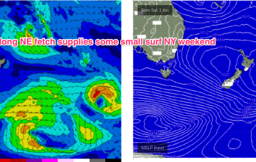
NE windswell looks to build from Thurs, as a dominant high drifts towards New Zealand, allowing winds from the western flank to form a coast hugging fetch south from Jervis Bay.