Into next week and no major swell sources on the radar. High pressure moves NE into the Tasman with as N’ly fetch off the NSW S Coast likely to generate some small NE windswell Mon.
Primary tabs
/reports/forecaster-notes/eastern-tasmania/2023/09/22/remaining-small-just-few-bits-and-pieces-the
freeride76
Friday, 22 September 2023

/reports/forecaster-notes/eastern-tasmania/2023/09/20/low-energy-outlook-so-grab-what-you-can
freeride76
Wednesday, 20 September 2023
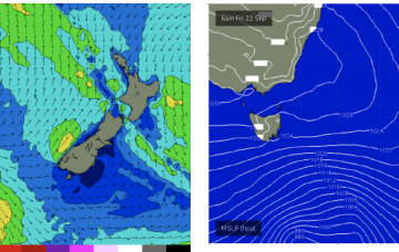
Small fronts and lows bring some minor S swell pulses to the NE corner later this week, before high pressure drifts across the Island and brings calm conditions. A few small swell sources are possible but in general we’re looking at a quiet period.
/reports/forecaster-notes/eastern-tasmania/2023/09/18/small-ne-swells-tend-small-s-swells-later-week
freeride76
Monday, 18 September 2023
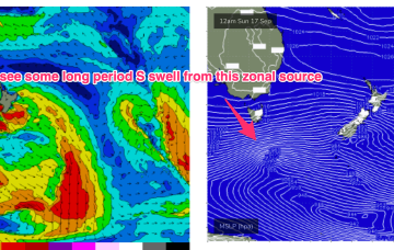
We’ve got another slow moving pattern on our hands to start the week with a high pressure belt at sub-tropical latitudes directing a W’ly to NW’ly flow across the state and a very zonal (W-E) storm track tracking through the far southern Tasman Sea.
/reports/forecaster-notes/eastern-tasmania/2023/09/15/small-and-variable-next-week-fresh-offshore
freeride76
Friday, 15 September 2023
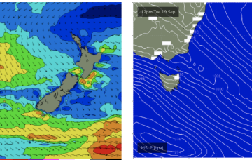
No great change to the weekend f/cast. High pressure in the Tasman and a W’ly biased ridge across Tasmania as fronts and a deep low pass to the south.
/reports/forecaster-notes/eastern-tasmania/2023/09/13/easing-s-swells-some-ne-swell-next-week
freeride76
Wednesday, 13 September 2023
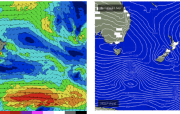
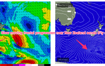
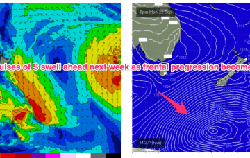
We still have a large (1032hPa) high slow moving over NSW directing light N’lies over Tasmania. A slow moving frontal progression is gradually working it’s way clear of New Zealand longitudes while sending pulses of S’ly groundswell our way. High pressure does clear the coast this week with an increasing N’ly flow before a zonal pattern brings a W-NW flow for the weekend.
/reports/forecaster-notes/eastern-tasmania/2023/09/11/sly-pulses-most-week-light-winds
freeride76
Monday, 11 September 2023
The high is slow moving, with a light W’ly ridge across Tasmania. We’ll see pulses of S’ly groundswell this week from the deep fetches located in the Far Southern Tasman.
/reports/forecaster-notes/eastern-tasmania/2023/09/08/plenty-strong-s-swell-the-radar-next-week
freeride76
Friday, 8 September 2023
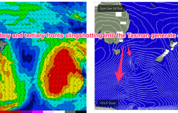
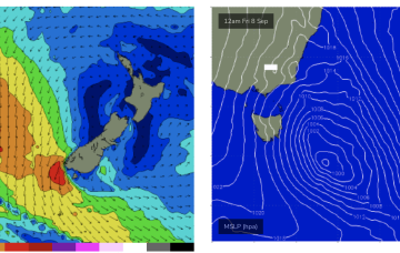
The headline act is a complex low system approaching Tasmania with an embedded front and linked to a long inland trough. A NE infeed into this system is producing swell from that quarter today and as the low clears the swell shadow of Tasmania we’ll start to see swells from the S. Following systems next week look to generate stronger, longer period S’ly swells.
/reports/forecaster-notes/eastern-tasmania/2023/09/06/another-round-chunky-ne-swell-ahead-plenty-s
freeride76
Wednesday, 6 September 2023
A front and small low are now racing across the Tasman with a high over NSW moving into the Tasman and directing a freshening N’ly flow across most of the Eastern Seaboard down to Tasmania. So far, so spring. A complex low, front and trough then approaches from the W, bringing a strong regime of W’ly-SW’ly winds and a series of S swells.
/reports/forecaster-notes/eastern-tasmania/2023/09/04/another-round-ne-windswell-week-sizey-s-swell
freeride76
Monday, 4 September 2023
The following system expected Fri this week now looks much stronger and under current modelling is expected to be a significant source of sizey S swell, potentially with several large pulses
/reports/forecaster-notes/eastern-tasmania/2023/09/01/solid-ne-windswell-ahead-spring-takes-hold
freeride76
Friday, 1 September 2023
S swells will be the dominant though easing force in the water through tomorrow, mostly mid period stuff whipped up by a proximate fetch of S-SSW winds generated by a front and trough of low pressure forming in the Tasman with some small longer period swell mixed in.
