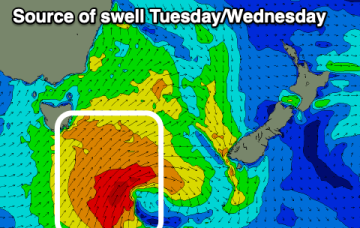
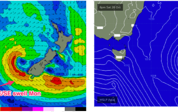
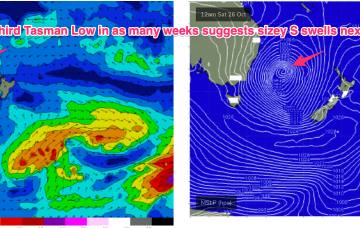
A complex but disjointed low has formed in the Tasman with diffuse centres off the North Coast and Tasmania/Gippsland coast. We’ll see S swells generated by the proximate fetches from this system easing into the weekend.
Primary tabs
/reports/forecaster-notes/eastern-tasmania/2024/10/25/mostly-the-small-side-few-fun-options-ahead
freeride76
Friday, 25 October 2024
/reports/forecaster-notes/eastern-tasmania/2024/10/23/more-s-swell-fri-and-next-week
freeride76
Wednesday, 23 October 2024
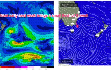
That will see a S wind change and some, windy but sizey S swells through the end of the week into the weekend. Lingering troughiness in the Tasman may see yet another low form next week- which would be the 4th successive surface low to form in October.
/reports/forecaster-notes/eastern-tasmania/2024/10/21/long-range-ene-swell-offers-few-quality-waves
freeride76
Monday, 21 October 2024
We'll see offshore winds develop Wed offering good conditions as a long range E swell makes landfall.
/reports/forecaster-notes/eastern-tasmania/2024/10/18/plenty-size-and-variety-ahead-next-week
freeride76
Friday, 18 October 2024
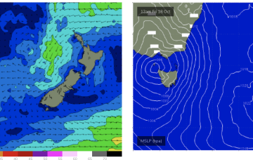
A low is expected to move E of Tasmania o/night and form a broad low pressure trough in the Tasman driving SW’ly then S’ly winds up the Tasmanian east coast before moving NE as a surface low over the weekend. That will be the second surface low in succession to form in the Tasman and we may yet see a third develop later next week.
/reports/forecaster-notes/eastern-tasmania/2024/10/16/sizey-ne-swell-expected-fri-mix-swells
freeride76
Wednesday, 16 October 2024
We’ll see a low skirting the Bight approach from the west result in freshening N’lies over the short term before entering the Tasman on the weekend, bringing another round of south winds and swell.
/reports/forecaster-notes/eastern-tasmania/2024/10/14/active-week-ahead-swells-around-the-compass
freeride76
Monday, 14 October 2024
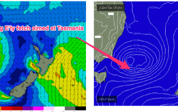
We’ve still got a dynamic week ahead as a trough currently off the Gippsland coast moves NE and develops into a broad surface low, backed by a high currently SW of Tasmania.

/reports/forecaster-notes/eastern-tasmania/2024/10/11/dynamic-week-next-week-low-forms-ne-tasmania
freeride76
Friday, 11 October 2024
The trough looks to rapidly deepen into a broad surface low off the Far South or Gippsland Coast o/night Mon into Tues. There’s still model divergence over the strength and position of this low which will have material impacts on surf size and local winds so stay tuned for updates over the weekend and on Mon.
/reports/forecaster-notes/eastern-tasmania/2024/10/09/quick-spikes-s-swell-possible-sizey-period-next
freeride76
Wednesday, 9 October 2024
From there things get more dynamic. The crux of it is a trough moving NE from Bass Strait which looks to rapidly deepen later Mon, possibly forming a broad surface low in the Tasman NE of Tasmania.

/reports/forecaster-notes/eastern-tasmania/2024/10/07/active-week-spikes-in-swell-around-the-compass
freeride76
Monday, 7 October 2024
Into next week, a polar low passing through the Southern ocean late next weekend looks to send some long period S swell up the pipe early next week

/reports/forecaster-notes/eastern-tasmania/2024/10/04/good-east-swell-the-weekend-decent-south-follow
Craig
Friday, 4 October 2024
The coming period is promising with great waves on the weekend followed by a good southerly swell mid-next week.