Massive surf from the Moreton Bay Islands across the Gold Coast and down through Northern NSW will continue until the cyclone crossing, with much smaller surf on the Sunshine Coast and into temperate NSW and down to Tasmania.
Primary tabs
/reports/forecaster-notes/eastern-tasmania/2025/03/05/chunky-ene-swells-tc-alfred-peak-over-the-next
freeride76
Wednesday, 5 March 2025

/reports/forecaster-notes/eastern-tasmania/2025/03/03/fun-surf-tc-alfred-reaches-tasmania-other-swell
freeride76
Monday, 3 March 2025
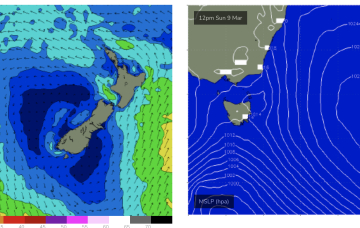
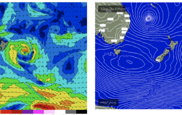
Alfred is expected to move SE today, generating mod to large swells down the NSW coast (it’s already solid in the sub-tropics!) and reaching all the way down to Tasmania.
/reports/forecaster-notes/eastern-tasmania/2025/02/28/more-small-surf-the-tropics-next-week-depending
freeride76
Friday, 28 February 2025
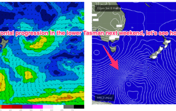
There are some model runs suggesting it penetrating the Tasman and developing a large wind field across the Tasman that would see larger E’ly swells into late next week.
/reports/forecaster-notes/eastern-tasmania/2025/02/26/small-surf-filtering-down-the-tropics-continues
freeride76
Wednesday, 26 February 2025
High pressure is in the Tasman with three tropical cyclones currently on the map. NETas will see some smaller surf from these systems as well as NE windswell.
/reports/forecaster-notes/eastern-tasmania/2025/02/24/small-swells-the-ene-filtering-down-the-tropics
freeride76
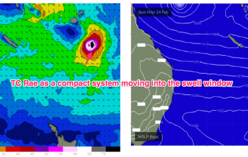
Monday, 24 February 2025
The trade-wind fetch is relatively robust and will be a long-lasting swell producer for the east coast, favouring sub-tropical areas for size with some small swell filtering down to NETas through the week.
/reports/forecaster-notes/eastern-tasmania/2025/02/21/sizey-ne-windswell-sun-then-not-much-next-week
freeride76
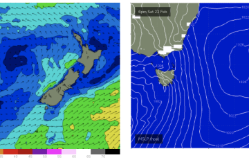
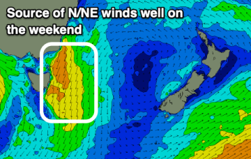
Friday, 21 February 2025
High pressure has moved into the Tasman and sits there over the weekend. It’s quite a strong high (expected to strengthen from 1025 to 1030 hPa) with a typical wind signature for this time of year- mod/fresh SE winds in the sub-tropics, tending to NE winds in temperate NSW and extending down to Tasmania.
/reports/forecaster-notes/eastern-tasmania/2025/02/19/sizey-ne-windswell-weekend-then-not-much-action
freeride76
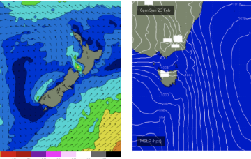
Wednesday, 19 February 2025
Following that, high pressure moving into the Tasman will supply another round of NE windswell over the weekend.
/reports/forecaster-notes/eastern-tasmania/2025/02/17/inconsistent-ene-swell-come-windy-building
Craig
Monday, 17 February 2025
There's still a fun though inconsistent E/NE swell inbound ahead of small south swells, and a stronger N/NE windswell on the weekend.
/reports/forecaster-notes/eastern-tasmania/2025/02/14/great-few-days-surf-ahead
Craig
Friday, 14 February 2025
We've got a mix of easing E/NE energy and building S/SE swell with decent winds.

/reports/forecaster-notes/eastern-tasmania/2025/02/12/sizey-the-ne-then-s-over-the-weekend
freeride76
Wednesday, 12 February 2025
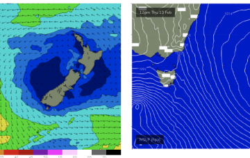
An active monsoon pattern is seeing a tropical low drifting in the Coral Sea with a supporting high approaching New Zealand and a slow moving trough line just off the NSW Coast, directing strong N’ly winds down into Bass Strait and adjacent to Tasmania.