Inconsistent E/NE swell to come, with a windy, building weekend

Eastern Tasmanian forecast by Craig Brokensha (issued Monday February 17th)
Best Days: Tomorrow, Wednesday, Sunday
Features of the Forecast (tl;dr)
- Small, easing SE swell tomorrow
- Small, inconsistent E/NE groundswell building tomorrow PM, peaking Wed AM, then easing
- W/NW tending strong S/SE winds tomorrow PM
- W/SW tending variable Wed ahead of possible weak sea breezes
- New small S swell Thu with W/SW-SW tending E then NE winds
- Fading swell Fri with N/NW tending NE winds
- Building N/NE windswell Sat with strong N/NE winds
- Peak in N/NE windswell Sun, easing rapidly with NW tending W winds
Recap
The surf was fun all weekend with easing levels of E/NE swell on Saturday morning with clean conditions, remaining decent in southern corners all day as winds strengthened out of the S’th.
Yesterday the E/NE swell was smaller but some new south swell filled in through the day as southerly winds continued to favour southern ends.
A mix of S/SE and E/NE swells have continued to provide good waves this morning ahead of sea breezes.
This week and weekend (Feb 18 - 23)
The coming week looks much smaller and trickier re surf, with our inconsistent E/NE groundswell for tomorrow afternoon and Wednesday coming in a little smaller.
This is thanks to the low linked to it, forming just north-east of New Zealand being a little less favourably aligned and further in the swell shadow.
With this we should still see inconsistent sets but don’t expect anything over 2-3ft.
The S/SE energy will fade away as well with easing 2ft+ sets due tomorrow morning as early W/NW winds shift strong S/SE into the afternoon.
Wednesday should then see W/SW offshores, tending variable ahead of possible weak sea breezes.
Swell sources will dry up from the east later week, while a weak front pushing up past us Wednesday evening should produce some small mid-period S’ly swell.
A small 2ft+ wave may be seen Thursday on the south magnets but with tricky W/SW-SW tending E and then NE winds, fading Friday as winds switch back to the NW to NE.
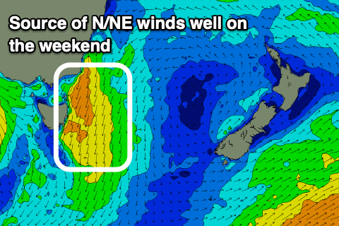
The weekend looks a little more productive as strengthening N/NE winds ahead of a mid-latitude low moving in from the west bring an increase in moderate sized N/NE windswell Saturday, peaking Sunday.
We could see this reaching the 4-5ft+ range early Sunday ahead of an offshore change, but more on this Wednesday.