Great few days of surf ahead
Eastern Tasmanian forecast by Craig Brokensha (issued Friday February 14th)
Best Days: Today, tomorrow, Sunday morning, Monday morning, Tuesday morning, Wednesday morning
Features of the Forecast (tl;dr)
- Moderate sized, inconsistent E/NE trade-swell easing slowly tomorrow, further Sun and Mon
- Moderate + sized S/SE swell for Sun, easing Mon
- W/SW tending strong S/SW winds tomorrow, strong S/SW tending S/SE Sun
- SW tending strong N/NE winds Mon
- W/SW tending strong S/SE winds Tue
- Inconsistent E/NE groundswell for later Tue, peaking Wed with W tending NE winds
Recap
The north-east energy muscled up through yesterday as winds strengthened through the day, building from 4-5ft in the morning to 6ft+ through the afternoon.
This morning conditions came in cleaner and with plenty of swell still in the tank with 4-5ft+ waves on the magnets. Conditions are still good this afternoon with the size only now starting to back off.
This weekend and next week (Feb 15 - 21)
The current NE energy will continue to slowly ease over the weekend as the infeed of local NE winds slowly retract away from the coast thanks to an incoming frontal progression moving in from the west.
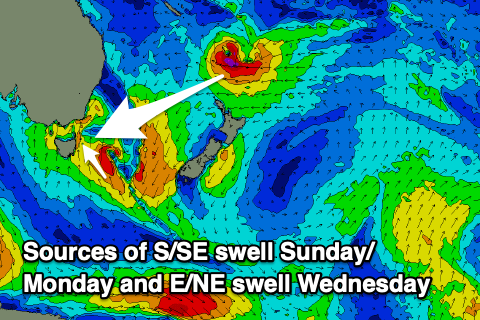
A healthy fetch of E/NE winds are still extending up into the Coral Sea as a tropical low squeezes high pressure sitting south-east of New Zealand and this will continue to produce less consistent but small to moderate levels of E/NE trade-swell all weekend and into early next week.

A slow drop from 3-4ft is due tomorrow with Sunday and Monday coming in at 2-3ft, while one final pulse of long-range groundswell as the low deepens and strengthens north of New Zealand’s North Island tomorrow should come in later Tuesday but more so Wednesday to an inconsistent 3ft+.
From Thursday the swell will then drop rapidly from 2ft or so.
Now, at the same time as all this E/NE swell energy fills in, a deepening trough south-east of us over the weekend should produce a great fetch of strong to near-galeforce S/SE winds and moderate sized increase in S/SE for Sunday and Monday morning.
South facing beaches are due to come in at 4-5ft+ Sunday, easing slowly from 4ft or so on Monday with Tuesday fading further in size.
Local winds will be offshore from the W/SW tomorrow morning but strengthen out of the S/SW through the day as the trough deepens, with Sunday seeing strong S/SW tending S/SE winds.
Monday looks cleaner through the morning with a light SW offshore before gusty N/NE sea breezes kick in, swinging back W/SW on Tuesday ahead of a strong S/SE change thanks to another trough moving through the region. Wednesday morning should be clean again before NE sea breezes kick in.
Longer term the outlook is slower but still active. More on this Monday. Have a great weekend!


Comments
*