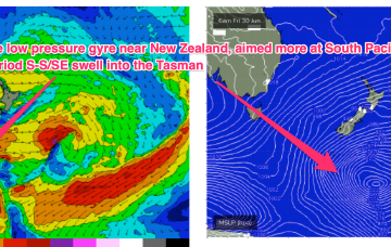
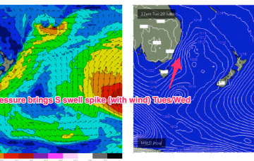
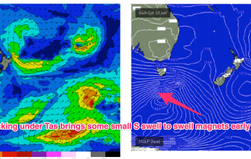
High pressure sitting up at sub-tropical latitudes is allowing a very active series of fronts to penetrate NE into the Tasman Sea. A very slow moving monster high tracking into WA longitudes is anchoring a sustained SW flow as the fronts ride up it’s extended flank from the Southern Ocean into the Tasman. We’ll see multiple S swell pulses from this set-up, becoming stronger over the weekend.
Primary tabs
/reports/forecaster-notes/south-east-queensland-northern-new-south-wales/2023/06/26/multiple-s-swell
freeride76
Monday, 26 June 2023
/reports/forecaster-notes/south-east-queensland-northern-new-south-wales/2023/06/23/quiet-weekend
freeride76
Friday, 23 June 2023
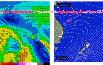
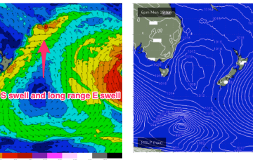
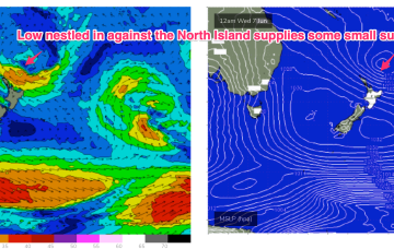
Long lined, inconsistent E-E/SE swell will continue next week, from a source near Tonga then a closer low forming on a persistent trough line closer to the North Island. This closer system is right on the edge of the swell window.
/reports/forecaster-notes/south-east-queensland-northern-new-south-wales/2023/06/21/more-active
freeride76
Wednesday, 21 June 2023
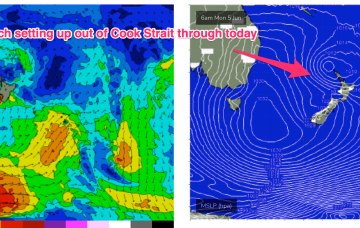
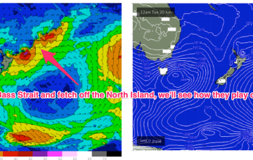
Yesterdays large area of low pressure consolidated nicely in the Tasman and is now slow moving as it approaches the North Island. The head of the fetch reached sub-tropical latitudes, aiding swell spread into SEQLD. Off-axis SSW-SW winds hold through today and tomorrow in the Central Tasman leading to a slow decline in S-S/SE swell for the region through this time frame.
/reports/forecaster-notes/south-east-queensland-northern-new-south-wales/2023/06/19/little-more
freeride76
Monday, 19 June 2023
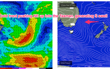
High pressure over the continent its still ridging along it’s Southern flank with a westerly belt creating flat, groomed conditions. A deep, compact low is well SW of Tasmania, weakening as it enters the lower Tasman. A decaying front linked to the low spawns a broad area of low pressure in the Tasman tomorrow and then lingers in the Tasman for most of the week.
/reports/forecaster-notes/south-east-queensland-northern-new-south-wales/2023/06/15/nice-conditions
freeride76
Friday, 16 June 2023
OK, the continent is covered in high pressure, now drifting out over NSW into the Tasman and right across our wide swell window we’ve got very placid sea states leading to a continuation of small, weak surf.
/reports/forecaster-notes/south-east-queensland-northern-new-south-wales/2023/06/14/options-next-week
freeride76
Wednesday, 14 June 2023
We’re midway through a pretty sleepy week, swell-wise. A high pressure cell is drifting across the interior of the continent with a trough/front connected to a high riding low pushing East of Tasmania through today. Thats’ driving a mod/fresh synoptic W’ly flow across most of NSW and extending up into the sub-tropics.
/reports/forecaster-notes/south-east-queensland-northern-new-south-wales/2023/06/12/fading-surf-some
Craig
Monday, 12 June 2023
The coming week is slow with nothing of note. Later next week holds better potential.
/reports/forecaster-notes/south-east-queensland-northern-new-south-wales/2023/06/09/fun-waves-over
freeride76
Friday, 9 June 2023
That will supply groomed conditions for a small but fun E/SE swell signal coming off the top of the North Island ( better aimed at targets to the North)
/reports/forecaster-notes/south-east-queensland-northern-new-south-wales/2023/06/07/spell-small-fun
freeride76
Wednesday, 7 June 2023
The evolution of the current pattern has sped up compared to Monday’s notes with high pressure drifting towards the South Island and weakening and a low centred around the North Island moving NE. A fetch off the top of the North Island is just scraping the edge of our swell window (better aimed at the sub-tropics).
/reports/forecaster-notes/south-east-queensland-northern-new-south-wales/2023/06/05/fun-mix-swells
freeride76
Monday, 5 June 2023
After a much more settled, stable May the first week of June is looking like a temporary back-slide into a more La Niña-esque pattern. A huge (1035hPa) high is sitting E of Tasmania with a low pressure system straddling New Zealand. The high is directing moist onshore winds right up the Eastern Seaboard, while the low has several swell producing fetches associated with it, albeit nothing too major.