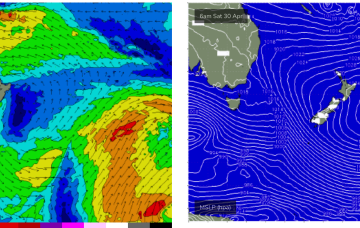
A large 1029 hPa high pressure system is sitting smack bang in the middle of the Southern Tasman Sea in a deepening phase, with a series of tropical troughs in the Northern Coral Sea beginning to expand Tradewinds through the tropics.
Primary tabs
/reports/forecaster-notes/south-east-queensland-northern-new-south-wales/2022/04/27/couple-small-days
freeride76
Wednesday, 27 April 2022
/reports/forecaster-notes/south-east-queensland-northern-new-south-wales/2022/04/26/some-small-clean
freeride76
Tuesday, 26 April 2022
Plenty of E swell ahead next week as Tradewinds and a sub-tropical low drifts south through the South Pacific slot.

/reports/forecaster-notes/south-east-queensland-northern-new-south-wales/2022/04/22/chunky-blend
freeride76
Friday, 22 April 2022
The chief factor will be wind and there’ll be plenty of it from the SE, as a dominant high moving across Tasmania builds a very firm ridge along the sub-tropical and tropical coasts of NSW and QLD.
/reports/forecaster-notes/south-east-queensland-northern-new-south-wales/2022/04/20/classic-autumn
freeride76
Wednesday, 20 April 2022
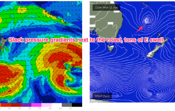
Further out in the South Pacific, well to the NE of the North Island, the remnants of the long trough line through the eastern swell window, have deepened, with a broad fetch of E/NE to E winds now activated

/reports/forecaster-notes/south-east-queensland-northern-new-south-wales/2022/04/18/easterly-swells
thermalben
Monday, 18 April 2022
There's no letup in the surf outlook for our region.
/reports/forecaster-notes/south-east-queensland-northern-new-south-wales/2022/04/15/stacks-swell
thermalben
Friday, 15 April 2022
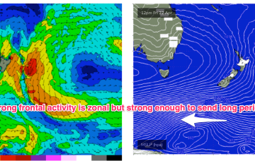
The developing trough in the northern Tasman Sea is reaching maturity as we speak.
/reports/forecaster-notes/south-east-queensland-northern-new-south-wales/2022/04/13/no-shortage
thermalben
Wednesday, 13 April 2022
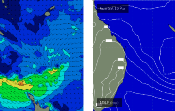
Lots on the menu for this weekend. Southerly swells will provide slightly waves in Northern NSW, but we have a better east swell on tap anyway.
/reports/forecaster-notes/south-east-queensland-northern-new-south-wales/2022/04/11/active-eastern
thermalben
Monday, 11 April 2022
We’ve got another strong pulse expected to fill in tomorrow.
/reports/forecaster-notes/south-east-queensland-northern-new-south-wales/2022/04/08/east-swell-keeps
freeride76
Friday, 8 April 2022
Very simple f/cast for our region this weekend so let’s not overthink it. Waves, waves and more waves on the Points with SE winds across the region.
/reports/forecaster-notes/south-east-queensland-northern-new-south-wales/2022/04/06/days-solid-e
freeride76
Wednesday, 6 April 2022
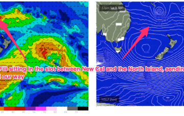
TC Fili is expected to become slow moving as it becomes cradled by the peanut high, with a persistent fetch of E’ly winds supplying an extended run of swell from that direction