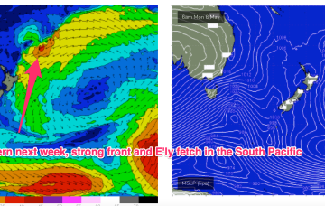
The strong reinforcing cold front is now almost across the Tasman with a large (1031hPa) high moving across from the Bight and already setting up a ridge along the QLD Coast. High pressure moves into the Tasman as we end the week with a dominant role into next week.
Primary tabs
/reports/forecaster-notes/south-east-queensland-northern-new-south-wales/2023/05/10/sizey-s-swell
freeride76
Wednesday, 10 May 2023
/reports/forecaster-notes/south-east-queensland-northern-new-south-wales/2023/05/08/sizey-the-s-nice
freeride76
Monday, 8 May 2023
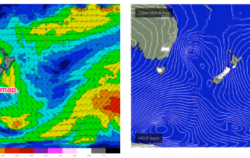
A 996 hPa low just off the coast and a 1034 hPa high in the Bight is creating a very tight pressure gradient with subsequent severe gales and an L-XL S swell event. The primary focus of this swell is temperate NSW inside the Hunter curve, with other areas seeing much less swell.
/reports/forecaster-notes/south-east-queensland-northern-new-south-wales/2023/05/05/nice-mix-s-and-e
freeride76
Friday, 5 May 2023
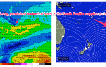
By Sunday we’ll see a deepening angled trough in the Tasman Sea with a low expected to form in the trough NE of Tasmania off the Gippsland Coast.
/reports/forecaster-notes/south-east-queensland-northern-new-south-wales/2023/05/03/few-small-days
freeride76
Wednesday, 3 May 2023
A much stronger cold outbreak looks poised to spawn a major Tasman Low Sun/Mon with the seasons first serious S swell expected.
/reports/forecaster-notes/south-east-queensland-northern-new-south-wales/2023/05/01/easing-clean-surf
freeride76
Monday, 1 May 2023
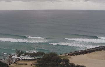
Low pressure troughs off the NSW and SEQLD coast combined with high pressure over the interior and frontal activity to the south are driving a W’ly flow across the Eastern Seaboard, perfectly timed for a quality E’ly groundswell. We’ll see a slow easing of this swell event over the coming days with all day offshores expected.
/reports/forecaster-notes/south-east-queensland-northern-new-south-wales/2023/04/28/dont-stop-til-you
thermalben
Friday, 28 April 2023
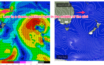
No shortage of east swell this weekend, with the low in the northern Tasman Sea generating some impressive energy that'll build through Saturday towards a peak early Sunday.
/reports/forecaster-notes/south-east-queensland-northern-new-south-wales/2023/04/26/run-e-swell-gets
freeride76
Wednesday, 26 April 2023
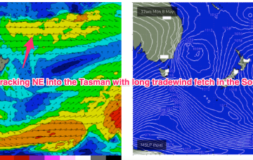
A broad trough of low pressure is expected to bud a surface low near New Caledonia over the short term, generating more quality E-E/NE swell as the low drifts through the South Pacific slot and into the Tasman.
/reports/forecaster-notes/south-east-queensland-northern-new-south-wales/2023/04/24/more-much-much
freeride76
Monday, 24 April 2023
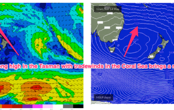
The major swell generator will a broad fetch of SE-E/SE winds in the Coral Sea/Northern Tasman which will be enhanced later in the week as a broad tropical low tracks southwards from New Caledonia and into the wide open Eastern swell window. This will keep the sub-tropical Points pumping with a rebuild in quality E’ly groundswell later this week and into the weekend.
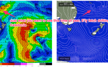
/reports/forecaster-notes/south-east-queensland-northern-new-south-wales/2023/04/21/great-run
thermalben
Friday, 21 April 2023
The trough block will break down over the weekend, to be replaced by a very strong high pressure system in the Tasman Sea
/reports/forecaster-notes/south-east-queensland-northern-new-south-wales/2023/04/19/plenty-more
freeride76
Wednesday, 19 April 2023
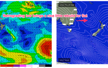
We still have the trough block pattern in place with the South Pacific low centre contracting away to the NE while a secondary low centre retrogrades back into he Tasman Sea. An anchoring high, is being shunted away with a trough and front expected tomorrow before a new dominant high moves in from the Bight.