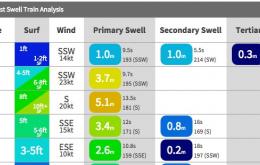
Saturday looks solid and windy although the models seem to be overcooking the size of the resulting swell from this Tasman Low.
Primary tabs
/reports/forecaster-notes/south-east-queensland-northern-new-south-wales/2015/05/20/small-few-days
thermalben
Wednesday, 20 May 2015
/reports/forecaster-notes/south-east-queensland-northern-new-south-wales/2015/05/18/small-surf-couple
thermalben
Monday, 18 May 2015
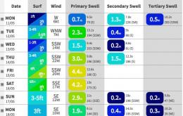
We’ve got a week of small waves ahead.
/reports/forecaster-notes/south-east-queensland-northern-new-south-wales/2015/05/15/strong-south
thermalben
Friday, 15 May 2015
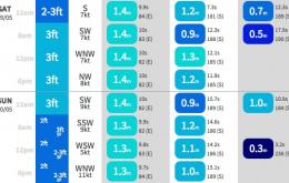
The overarching theme remains in place for the weekend mainly due to no changes in the forecast wind regime.
/reports/forecaster-notes/south-east-queensland-northern-new-south-wales/2015/05/13/large-and-windy
thermalben
Wednesday, 13 May 2015
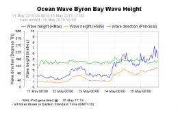
It’s all south swell for the next few days.
/reports/forecaster-notes/south-east-queensland-northern-new-south-wales/2015/05/11/extended-run
thermalben
Monday, 11 May 2015
Several low pressure centres will each contribute strong energy from Thursday afternoon through Friday, and on the whole we’re looking at very large surf in the 6-8ft+ range (Northern NSW south facing beaches) at the height of the swell.
/reports/forecaster-notes/south-east-queensland-northern-new-south-wales/2015/05/08/great-weekend
thermalben
Friday, 8 May 2015
All in all - a great weekend for most open beaches.
/reports/forecaster-notes/south-east-queensland-northern-new-south-wales/2015/05/06/persistent
thermalben
Wednesday, 6 May 2015
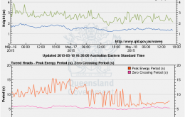
There’s not much to glean from the latest swell model data.
/reports/forecaster-notes/south-east-queensland-northern-new-south-wales/2015/05/04/another-great
thermalben
Monday, 4 May 2015
The good news is that we’ve got plenty of swell on the way for this week, although things have been rejigged since Friday’s forecast was issued.
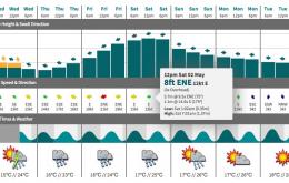
/reports/forecaster-notes/south-east-queensland-northern-new-south-wales/2015/05/01/large-wet-and
thermalben
Friday, 1 May 2015
The only thing that’s going to stop this cacophony is the ECL shifting southward. But even at less than a day out, the outlook is still very complex - it’s hard to be exactly sure what will pan out tomorrow.

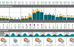
/reports/forecaster-notes/south-east-queensland-northern-new-south-wales/2015/04/29/wild-wet-and
thermalben
Wednesday, 29 April 2015
So, as this trough/low slides southwards, conditions will rapidly improve. First on the Sunshine Coast (early Saturday), then the Gold Coast, and so on as we traverse along the Northern NSW Coast.