Dynamic outlook but mostly windy

Victorian forecast by Craig Brokensha (issued Friday March 28th)
Best Days: Today exposed beaches, dawn tomorrow to the east, selected spots to the east Tuesday and Wednesday, Friday morning Surf Coast
Features of the Forecast (tl;dr)
- Easing SW swell tomorrow with a dawn S/SW change, moving east by mid-AM, strong S into the PM
- Building S windswell later tomorrow with a moderate + sized SE windswell Sun with strong SE winds
- Moderate sized mid-period SW swell Sun
- Moderate + sized SW groundswell building later Mon, peaking Tue, easing slowly Wed
- Easing SE windswell Mon with strong SE winds, fresh SE Tue
- Mod-fresh E tending SE winds Wed
- Small E/SE groundswell later Tue and Wed
- Small Thu with strong W tending SW winds
- Building mid-period SW swell later Thu, easing Fri with W/NW winds
Recap
The swell has slowly eased off after Wednesday afternoon’s pulse, with bumpy 3-4ft waves seen across the Surf Coast yesterday, a little more doable further east and more so towards Phillip Island thanks to a weaker onshore flow.
This morning is smaller and better for the beaches with 2ft+ of swell across the Surf Coast magnets along with peaky conditions, smoother and best to the east with 4ft sets hanging in the mix. A reinforcing mid-period swell should maintain similar sized waves into this afternoon with sea breezes due by about mid-afternoon.

Fun surf today
This weekend and next week (Mar 29 - Apr 4)
The small reinforcing mid-period swell for this afternoon will start to ease tomorrow with 2ft sets due on the Surf Coast and 3-4ft waves to the east, easing through the day.
The window of early light N winds look limited now mostly to the east, with a trough expected to bring a strengthening S/SW-S change by dawn on the Surf Coast, delayed to 7:30-8am to the east.
This change will bring a localised increase in windswell through the afternoon, while Sunday will see a shift in the wind direction to the SE as the trough feeds into a deepening low to our east. The low will be strongest out in the Tasman Sea, but the local strong SE winds on Sunday will kick up a moderate + sized, stormy SE windswell that looks to come in at 4-5ft+ on the Surf Coast.
To the east, a new mid-period SW swell is due to be in the water, generated by a polar front projecting towards us today, and this looks to provide 4-5ft sets on the exposed beaches.
The south-east flow will start to ease on Monday (but remain strong) and with it, the local SE windswell will drop, but the low itself in the Tasman Sea will likely generate some sneaky E/SE groundswell for Tuesday afternoon and Wednesday, but we’ll have some larger SW groundswell in the water.
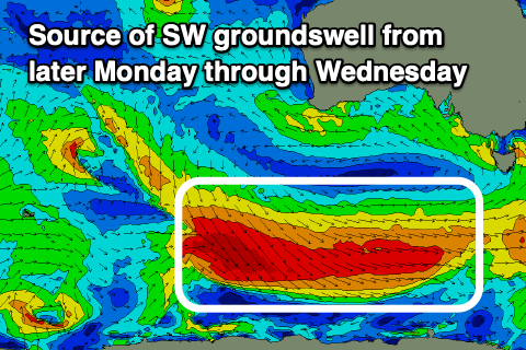
As touched on in the notes earlier in the week, a strengthening polar frontal progression firing up under the country from today will see a great, elongated fetch of gale to severe-gale W-W/NW winds pushing through our south-western swell window (strongest into tomorrow and Sunday morning). An extended, moderate + sized SW groundswell is due from later Monday but more so Tuesday, easing slowly Wednesday.
The Surf Coast should come in at 4-5ft through Tuesday with 6ft sets likely through the afternoon while the Mornington Peninsula building to 6-8ft.
Winds will unfortunately be fresh out of the SE on Tuesday, limiting options with the low to our east weakening into Wednesday, allowing winds to ease and tend more E’ly as the groundswell eases from 3-5ft and 6ft+ respectively west and east of Melbourne.
Into Thursday, an approaching mid-latitude low will shift winds strong W tending SW, creating deteriorating conditions with smaller, easing surf across all locations, ahead of the mid-period swell from the low itself later in the day and more so Friday.
The models diverge regarding the size and follow up activity but the Surf Coast looks fun through Friday into next weekend. More on this Monday. Have a great weekend!