Decent today, fun Friday

Victorian forecast by Craig Brokensha (issued Wednesday March 26th)
Best Days: Today, beaches Friday ahead of late sea breezes, dawn Saturday, possibly Surf Coast next Wednesday morning
Features of the Forecast (tl;dr)
- Easing mix of swells tomorrow with mod-fresh S/SE winds, weaker to the east and more variable across PI in the AM
- Smaller Fri, with a reinforcing swell for the PM, easing Sat
- Light N/NE winds Fri AM ahead of mid-late PM sea breezes
- Dawn N winds Sat ahead of a strenthening S/SW change
- Strong SE winds Sun with a moderate + sized SE windswell building through the day
- Small-mod sized mid-period SW swell for late Sun but more so Mon with easing levels of SE windswell
- Gusty S/SW winds Mon
- Gusty S/SW winds Tue with a mod-large S/SW groundswell
- Easing swell Wed with SW winds (likely W/NW early Surf Coast)
Recap
The beaches to the east offered the best waves through yesterday under light east winds, good in the morning with the early high tide and coming in between 3-5ft. 13th Beach was best to the west with bumpy waves around Torquay thanks to fresher southerly wind.
Today we’ve got a light to moderate southerly breeze across most spots, though fresher in certain locations, and a strong mix of building long-range groundswell and closer-range energy. Cape Sorell is showing some nice numbers and we should see the Surf Coast reaching 4-5ft with 6ft+ sets to the east as winds only slowly increase from the S-S/SE.

New swells filling in this morning
This week and next (Mar 27 - Apr 4)
Today’s building mix of groundswells will peak this afternoon/evening and ease off through tomorrow as winds remain an issue for most locations.
A moderate to fresh S/SE breeze is due across the Surf Coast with lighter winds on the Mornington Peninsula, possibly tending a little more SE and then even weaker winds across Phillip Island.
While not great, selected spots to the east could be OK with easing 5-6ft sets (3-4ft on the Surf Coast).

Friday is still the pick for the beaches as an inland low drifts south towards the south-east corner of the country, tipping winds N/NE with it. This will create great conditions along with a further drop in swell energy back from 2ft+ on the Surf Coast and 4ft on the sets to the east. A small reinforcing SW swell is due through the afternoon, generated by a weak fetch of W/NW winds currently moving in from the west, south of Western Australia but it looks to maintain similar sized waves to the morning.
Conditions should remain favourable until mid-afternoon to the east before sea breezes finally kick in.
Saturday will come in a touch smaller than Friday with the small mid-period swell easing back from 2ft with 3-4ft sets to the east and light, local offshore winds should create clean conditions at dawn ahead of a trough and strengthening S/SW change by mid-morning.
Now, as touched on in Monday’s notes, the trough will merge with the inland depression, forming a low off the East Coast through Sunday/Monday, with poor, strong SE winds feeding into the deepening system Sunday due to kick up some localised SE windswell to 4-5ft on the Surf Coast (smaller to the east).
Winds are due to ease on Monday and swing more S/SW as the low drops south, with easing levels of SE windswell and some new mid-period swell from a weak front projecting towards us through Friday/Saturday.
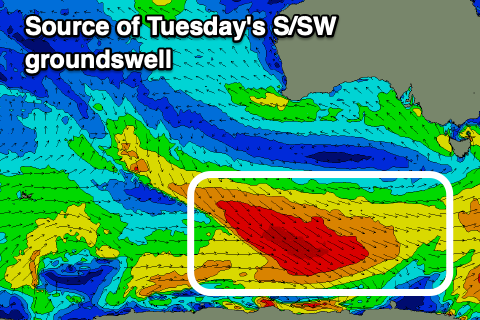
Unfortunately gusty S/SW winds look to persist on Tuesday as a strong S/SW groundswell fills in, with weaker SW winds on Wednesday possibly allowing a chance for a local land breeze on the Surf Coast along with plenty of SW groundswell energy hanging in the mix.
The source of multiple pulses of swell for early to mid-next week will be a train of strengthening polar frontal systems from later this week, swinging under the country and skirting the polar shelf.
An initial weak frontal system should generate some mid-period SW swell for Monday, while a stronger fetch of gale to severe-gale W/NW winds will produce a moderate to large sized S/SW groundswell for Tuesday to 4-5ft on the Surf Coast and 6ft to occasionally 8ft to the east.
We’ll take a closer look at this on Friday.