Make the most of today
Victorian Surf Forecast by Craig Brokensha (issued Friday 4th March)
Best Days: Today
Features of the Forecast (tl;dr)
- Low point in swell tomorrow with fresh W tending SW winds
- Mix of new swells Sun with strong S/SW tending SE winds
- Slight drop in size Mon with gusty SE tending S/SE winds
- Moderate sized SW swell Wed with strong E-E/SE tending S/SE winds, easing Thu and Fri with moderate SE tending fresh S/SE winds
Recap
Windy though improving conditions across the beaches east of Melbourne through yesterday with an inconsistent groundswell in the 3-4ft range, while the Surf Coast was a peaky 2ft+ or so on the beaches, bumpy elsewhere but improving into the afternoon.
This morning the swell is still hanging in there with great winds for the beaches but expect a drop in size through the day and a late S/SW change. There'll be plenty of time to get a couple if not three surfs in today though.
This weekend and next week (Mar 5 – 11)
These notes will be brief due to communication issues with our other forecasters in northern NSW.
Give the weekend a miss as a trough brings a fresh W'ly tending SW breeze tomorrow but with tiny waves on the Surf Coast, then strong S/SW tending SE winds on Sunday as a trough deepens into a deep low off the southern NSW Coast.
 Some inconsistent new SW groundswell is due Sunday mixed in with localised windswell coming in at 3ft on the Surf Coast and 4-5ft to the east.
The swell looks to ease a touch in size and period Monday as winds remain poor and gusty out of the SE, possibly tending E/SE for periods east of Melbourne during the morning.
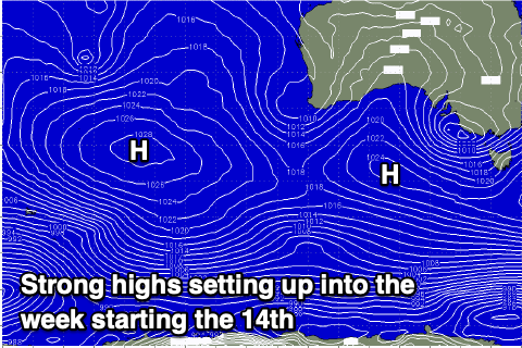
Unfortunately a strong high will fill in from the west on Tuesday bringing strengthening S/SE winds which will create poor conditions across all locations with a touch less swell again.
It looks like winds may dip temporarily to the E-E/SE on Wednesday morning before reverting back to the SE through Thursday and Friday though moderate in strength.
 Swell wise a fun new mid-period SW swell is due on Wednesday, generated by a healthy polar frontal system moving in from a position east of the Heard Island region tomorrow, under the country early next week.
Surf to a good 4ft+ is due on the Surf Coast, 6ft+ to the east but with those tricky winds. We'll see the size slowly ease into the end of the week but with the unfavourable winds.
Longer term high pressure looks to dominate our main swell windows resulting in persistent easterly winds and no major surf. More on this Monday, have a great weekend!


Comments
It’s march f#%k of easterlies.
Hey Craig, with all this humid air kicking around and a lack of westerly storms to blow it all away: what is the likelihood of Gary & his mates in Vic copping a big wet load from the sky over the long weekend next weekend?
Wouldn't mind a bit of this right now!
Ahhh yesssss. East coast vicco does those lovely glass offs couple with fun small swell very nicely.
Holy shit, I'm not one to use cams but those Phillip Island cams are game changers.
How's the middle wave in that 2nd photo!
How'd the pack let that that one go through to the keeper?
Can we get a Cat Bay camera please?
yeah gotta say those sand formations look deluxe
YUCK!
That’s heinous. And nothing of note in the extended forey for the Surf Coast.
Easter is not too far away...
Hey Craig, wondering if you lovely people at Swellnet could write one of your analysis articles on what this autumn could look like in Vicco? I've recently been out of the water with a new born son late last year and I'm getting excited to jump back in the water now he's a bit bigger. I'm frothin for some decent surf coast swells. How's the big picture forecast looking for in the next few months? K