Lots to work with this weekend with varying winds
Southern Tasmanian Surf Forecast by Craig Brokensha (issued Friday August 25th)
Best Days: Late today, tomorrow, Sunday morning, Monday morning, Tuesday, Wednesday morning
Features of the Forecast (tl;dr)
- Moderate sized W/SW groundswell building Fri PM with W/SW-SW winds, tending W/NW on dark
- Moderate sized SW groundswell Sat, easing with light W/NW tending variable winds, SE later
- Moderate sized, reinforcing S/SW swell Sun with light W/SW tending fresher S/SE winds
- Easing S swell Mon with N tending fresh E/NE winds
- Small SW groundswell Tue and Wed AM, easing
- Strengthening N tending N/NE winds Tue, W/NW tending SW Wed
Recap
Wednesday afternoon's strong pulse of W'ly groundswell from the 'bombing low' was followed by a reinforcing pulse of W/SW energy yesterday morning to 3-4ft with great conditions though straight sets. This morning we saw smaller surf with onshore winds thanks to a cold front attached to a secondary strong low clipping us.
This weekend and next week (Aug 26 – Sep 1)
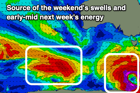
Currently, a strong and significant low is sitting south-west of us, aiming gale to severe-gale SW-S/SW winds up through our southern swell window.
Going back to yesterday though and we saw gale to severe-gale W/NW winds generating this afternoon's building swell, with the swell due to swing more SW in direction tomorrow and then come from the S/SW on Sunday.
Size wise, tomorrow looks to be 3-4ft across Clifton, easing through the day, with the new S/SW swell Sunday maintaining 4ft surf across Clifton, easing from 2-3ft on Monday.

Winds tomorrow look favourable with a light W/NW tending variable breeze ahead of late SE sea breezes.
Winds on Sunday look a touch funky now and light from the W/SW, ahead of fresher S/SE sea breezes. The morning will be best for a surf.
Monday will be clean through the morning with a N'ly offshore ahead of E/NE sea breezes.
Our small pulses of SW groundswell for Tuesday and Wednesday morning are on track, with a polar fetch of W/NW gales due to produce fun levels of swell to the 2ft range.
N tending stronger N/NE winds are due on Tuesday with a trough bringing a change Wednesday with W/NW tending SW winds.
Longer term, continued polar frontal activity to the south of Western Australia looks to bring fun sized surf later next week and into the weekend with more favourable winds. More on this Monday. Have a great weekend!

