Large southerly swells inbound

South-east Queensland and Northern NSW Surf Forecast by Ben Matson (issued Mon Jan 13)
Features of the Forecast (tl;dr)
- Small average NE swells Tues/Wed with winds from the same direction
- Large S'ly swell building Thurs/Fri but very windy
- Secondary E/NE swell building Fri
- Large combo of S'ly and E'ly swell for the weekend, though likely to be windy
- Large though easing SE swell during the first half of next week with rapidly improving conditions
Recap
Small E’ly swells padded out most coasts over the weekend with size around 2ft to at times 3ft. Conditions were generally OK though some regions did experience onshores at times on Saturday (in conjunction with heavy rain patterns too). Improving conditions on Sunday have persisted into this morning.
This week (Jan 14 - 17)
Main features on the synoptics this week are an approaching front from the west, a strong high just west of New Zealand and and a deepening surface trough in the northern Tasman Sea - the latter of which will feed additional moisture into an already-evolving dynamic setup.
The short term outlook maintains peaky E’ly swells from a series of disjointed, modest fetches in the northern Tasman Sea. Ordinarily we wouldn’t bat an eyelid at these kinds of setups, but if the banks are good and local winds are light and variable - which they should be in general, north from the MNC where we will otherwise see freshening N/NE winds - then we should find fun peaky beachies in the 2-3ft range.
Note: “variable” winds means “from any direction” - whilst we will probably see onshores prevail across most locations, I’m not expecting much strength on most coasts for the next few morning, so expect lumpy but workable options. Wednesday afternoon has a risk of freshening NE breezes in all areas though.
Thursday is where things really become juicy though Friday will be the most dynamic day of the working week.
The approaching front will push into the Tasman Sea overnight Wednesday, driving gale force southerly winds the length of the East Coast - eventually stretching from Tasmania up into Queensland’s Capricorn Coast.
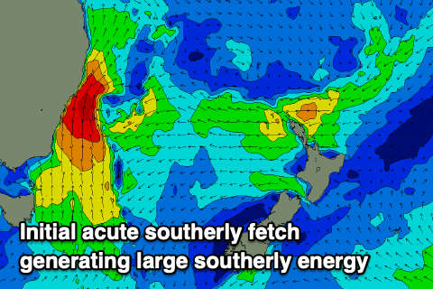
Most locations will see N’ly winds on Thursday ahead of the change, so expect average conditions - but the southerly should reach the Mid North Coast around mid-late morning, Yamba mid-late afternoon and the Qld border around dinnertime.
Building southerly windswells in its wake will confine the only rideable waves to protected southern corners, though we’ll also see building E/NE swells from a fetch located in the central/northern Tasman Sea earlier this week. The late arrival of the change may prevent there from being any worthwhile options across the SE Qld points before dark, but locations further south could enjoy a window of opportunity.
Friday will be dictated by gusty southerly winds and building southerly windswells (6-8ft south facing beaches south of Byron) and a steady mix of E/NE swell (3-5ft elsewhere). So, sheltered locations only.
This weekend (Jan 18 - 19)
A developing Tasman Low on Friday will mature into a multi-centered system over the weekend, maintaining large waves and windy conditions across exposed coasts.
There are a couple of interesting features to examine, that are highly relevant for surfers.
First up, we may see the low retrograde to the west, which could eventually allow gale force southerly winds to ease in strength, and steer around to the SW or even W/SW.
The timing on this scenario is not yet clear - earlier model runs suggests this might happen on Sunday, but the latest runs have pushed it back to Monday or maybe even Tuesday - but given the windy conditions expected later this week, it’ll be worth eyeing upcoming windows of improvement as the sea state will otherwise be a terrible mess for a while.
Secondly, whilst most Tasman Lows often display a single, broad wind field on its south-western flank (with direction often covering every degree from the S/SW through to the E/NE), in this instance it looks like the early stages of this developing Tasman Low may have two singular swell trains - one from the east and one from the south. Note: the easterly fetch will be aimed into the Mid North Coast so will have less influence across northern locations (re: SE Qld).
Given the expected windswell noise (from the local southerly gales) this may be a moot point, but there could be benefits for surfers from two distinct, narrower swell energies, rather than a singular event from an overly broad range of size, period and direction. Truth be told, I’m not really sure either way - but it’s a discussion worth having in advance.
As for size, we really need to look at locations north and south of the border in separation.
Expect 6-8ft+ surf at south facing beaches south of Byron on Saturday easing to 6ft+ on Sunday, with a solid E’ly swell in the mix (maybe 4-6ft across the MNC, but smaller in the north around 3-ft). It’s highly likely that the surf will be wind affected for the most part under a gusty S/SW airstream.
North of the border, SE Qld can expect a wide range of wave heights, from a wind affected 4-5ft at south swell magnets, to 2-3ft along the semi-exposed points (size will then ease into Sunday). Sheltered points will be much smaller this weekend, so keep your expectations in check.
Anyway, this is a complex scenario, so expect some revisions in Wednesday's update.
Next week (Jan 20 onwards)
Current expectations that the Tasman Low will remain active in NSW’s swell window until at least next Wednesday, though it should weaken through the first half of the week.
Also, we’ll see the aforementioned fetches consolidate into a more typically broad SE flow too, which will result in a smaller southerly component (in the swell direction).
More importantly, winds should ease and swing offshore early in the week so this time frame is currently earmarked for the best waves from this expected lengthy swell event.
South facing beaches south of Byron should rebuild to 6-8ft at some stage on Monday and/orTuesday, and there’ll be solid options across the semi-exposed points. Winds will also ease rapidly so expect a major improvement in conditions.
Unfortunately for size prospects in SE Qld, I fear that the poor alignment of this Tasman Low will keep a lid on wave heights across the regional points. Yes, we’ll see some great waves but current thinking is that 3ft, maybe 3-4ft may be the most we’ll pick up sometime Monday or Tuesday, before it eases through the rest of the week. South swell magnets will however be much bigger, and with the lighter winds may also be an option.
I’ll have more details over the updates later this week.
Comments
Nice one Steve, lets hope for some good windows of opportunity, at least with a ENE swell filling in southern corners there should be some waves to feed the hungry hoarde
Ben
Haha good pickup, just assumed Steve
Stoked that the swell its not XL in QLD there are some good beach break banks around
Night and day to yesterday. 2-3ft (with a bit of push) and a couple of bomb sets pushing 4. Good bit of sand at a magnet, but was not expecting that seeing the tiniest uptick on the buoy. Best morning in a while.
Agree, today was a supprise , few head high drops not a lot of power but nice change, tide might have killed it, I’m north of the bridge
Yep, I watched the buoy climb a fraction late yesterday, but this morning was a pleasant surprise. Consistent too. South of the bridge.
And it's gone
Good old sunny coast
Really? Tide kill it? Are you top, middle or bottom end?
Was good fun this morning!
So much fun where I was on the SC!! Most fun I've had in the surf in a while.
Same, was my best surf since October
I was mid SC...couldnt find anything decent. gave in.
Few better 3ft sets this AM before the tide claimed it.
Looks like the large, extended run of swell for the end of the week into next has all but gone from the latest model run, now getting a south swell Friday and back to 2ft. Say it ain't so Ben?
It ain't so.
It def aint so. Gee I'm hoping EC comes to fruition. really liking the look of that elongated fetch out in the Tasman
Thanks lads, you've lifted my spirits! I'll go take a look at the EC model to get me pumped again haha
Very fun this arvo, best waves I've had in ages
Shoulda been here yesterday.
SC, one decent day in 6 months and ya miss it due to prior commitments.
I am head butting the wall looking at real estate elsewhere.. .. :)
Painful.....
Downgraded outlook?
South swell yes. Models now downgrading coastal low intensity and positioning (not so close to coast). This unfortunately also means winds will be more S/SE which isn’t great either.
Me thinks the models are bouncing around as they’re struggling with the influence of the NW WA TC.
Thanks
Is there a reason why Queensland forecasts are put up after W.A and S.A ..?as seeing they are 2 to 3 hours behind us it sorta does not make sense to me .
Steve is on leave this week, so I'm doing them (on top of my regular work). Craig does SA/Vic/WA etc so he works off a different timetable.
NNSW/Qld forecasts will be up around 5pm.
..and, it's just queensland..