Stacks of swell and wind for the short term; next week looking really good

Sydney Hunter Illawarra Surf Forecast by Ben Matson (issued Wed Jan 15)
Features of the Forecast (tl;dr)
- Large S'ly swell building Thurs/Fri but very windy
- Secondary E/NE swell building Fri
- Solid combo of S'ly and E'ly swell for the weekend, windy for the most part but a temp window of lighter winds Sun AM
- Large SE swell Mon with better conditions
- Solid E'ly swell for Tues with good winds
- S'ly change Wed
Recap
Peaky NE swells maintained fun 2-3ft waves across most Sydney beaches on Tuesday, easing to 2ft today. Winds have been light through the mornings before freshening NE from about lunchtime onwards.
This week (Jan 16 - 17)
No major changes for the rest of this week.
A strong front will push into the Tasman Sea early Thursday morning, reaching the Illawarra just before dawn, into Sydney shortly after sunrise, and up across the Hunter around mid-morning.
Ahead of it we’ll see a brief window of light offshore winds, but unless you’re north of Sydney there probably won’t be much to capitalise on. Freshening NE winds off the Mid North Coast and Hunter regions this afternoon should generate some useful NE swell somewhere between 2ft and maybe 2-3ft, but it’ll only show at a handful of swell magnets at dawn.
Once the southerly arrives, winds speeds will rocket up to gale force or more, so the rest of the day will be a write-off for all but the most sheltered southern corners. It’ll take some time for the local windswell to build in the lee of the change, but we should see stormy 6-8ft sets at south facing beaches by close of business.
Although the broadscale synoptics have moved around for Friday (since Monday’s notes were issued) - the main difference being a northward stalling of the front across Northern NSW - this has only helped to anchor in the likelihood of gale to storm force S’ly winds across Southern NSW. Which, in turn has upped size projections a little; we’re likely to see stormy 8-10ft sets at south facing beaches.
Thursday afternoon and Friday should therefore be well suited to anywhere offering shelter from this wind direction, as wave heights will be much smaller and more manageable at these spots.
As a side note, I am also still expecting a healthy E/NE swell to fill in underneath Friday’s local noisy southerly event, though it’ll be hard to distinguish this energy.
This weekend (Jan 18 - 19)
A few changes to the outlook for the weekend, but in general I’m still anticipating better surf early next week.
Friday’s stalled southerly across Northern NSW will push northwards into Saturday and Sunday, slowly easing the pressure gradient across Southern NSW and resulting in a slow drop in wind speeds (and thus local windswell).
However, Southern NSW’s swell window will have remained very active through Friday so surf size will be quite big to begin with, probably still 5-6ft+ at south facing beaches, and with accompanying southerly gales across many regions, easing in strength south from the Illawarra. Expect conditions to moderate through the day.
A decent but smaller E’ly swell will also be in the mix on Saturday, though again it’ll probably be hard to notice.
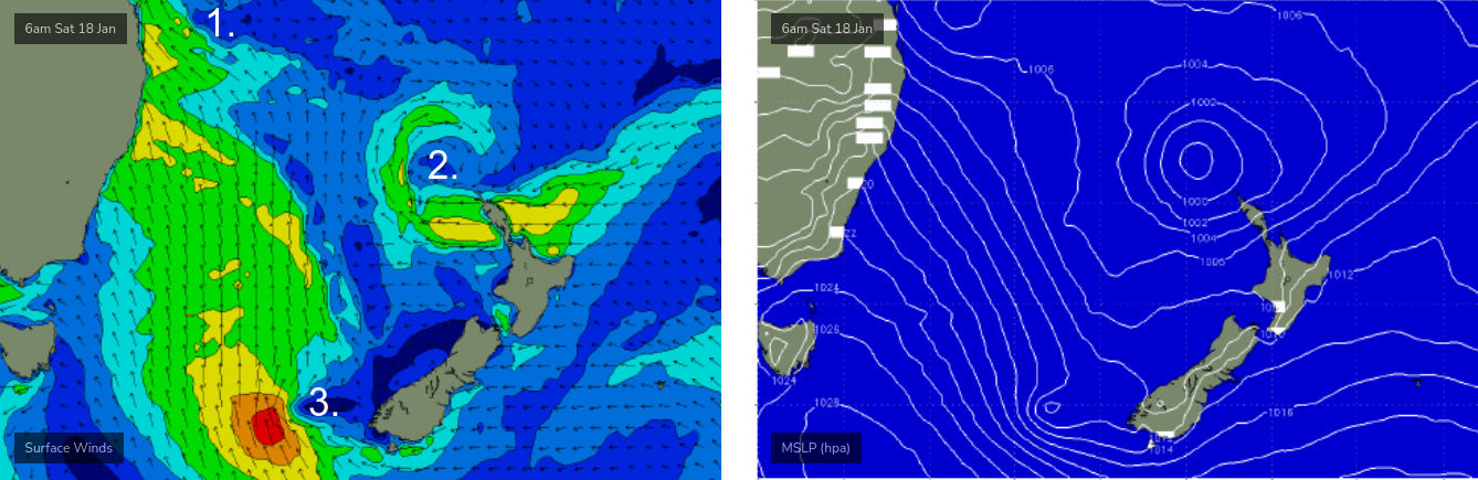
Sunday looks quite complex on the charts with a myriad of low pressure centres across the Tasman Sea.
A developing low off Northern NSW (see 1 below) will maintain gusty winds in this region, whilst another low just north of New Zealand (see 2 below) will have its easterly fetch bisected by the North Island.
Of greater interest to Southern NSW is a third low pressure centre that will develop off the south-western tip of New Zealand’s South Island on Saturday (see 3 below), and track north-west towards Australia's east coast, strengthening S/SE thru’ SE winds that will deliver excellent waves for Monday.
But prior to then - on Sunday morning - we’ll see a temporary low point in local southerly winds and a mix of swells from the south and east in the 3-5ft range. There’s a reasonable chance for a brief window of lighter SW winds in some regions, but we can still expect a fair degree of surface wobble at exposed spots thanks to the previous three days of southerly gales.
Southerly winds will then freshen through the afternoon as the aforementioned low pushes close to the mainland, so don’t expect the morning’s window to be open for too long.
I’ll refine my thinking on this in Friday’s notes. But.. there are some options starting to open up for the weekend.
Next week (Jan 20 onwards)
The low pressure system approaching from the south-east on Sunday looks like it’ll deliver a great day of large waves on Monday, pushing 6-8ft at exposed spots. Swell direction should be mainly SE, perhaps a touch of S/SE so expect smaller surf inside southern corners.
More importantly, the swell periods should be nicely drawn out and local winds should steer around to the SW as the low eases and moves away from the coast - both factors of which should improve wave quality markedly from the weekend.
Strong to gale force easterly winds are expected to develop through the eastern Tasman Sea from Sunday onwards - feeding into the tail end of the same low pressure system - and they’re looking to generate a strong secondary E’ly swell for Tuesday.
Not all of the models are in agreement with this synoptic situation right now, but I’m comfortable to put something on the table for now - let’s aim for 4-6ft surf with light offshore winds.
Wednesday will see a steady easing of easterly swells, and a fresh southerly change ahead of an associated southerly swell.
More on this in Friday’s forecast.
Comments
Fuck yes
The low hasn't formed yet so all models are still predictions. This event could go in many directions- including, I hate to say, one big onshore mess. I hope not but I'm not going into froth mode just yet.
A big onshore mess is very likely for much of the next four days. Sunday AM the outlier.
Give us some new banks PLEASE HUEY!!!!!
Great bank had finally formed at my local.
Probably gonna get smashed to smithereens
The sky was doing crazy things for the early surf today. Incredible lightning storm offshore north of Narra, glassy and offshore with a brief clear window then a hell dark shelf cloud from the south sweeping through. Was all over soon after, howling southly and pissing down
Nice view of this morning's shelf cloud via our new Bondi surfcam.
https://www.swellnet.com/surfcams/bondi