Indonesia/Maldives forecast Jan 14

Indian Ocean Basin analysis by Craig Brokensha (issued Tuesday 14th January)
This week through next (Jan 15 - 24)
Following a small pulse of energy the last couple of days, we then look ahead to our large, long-period SW groundswell due to build strongly through tomorrow ahead of a peak into Wednesday morning.
This will then be followed by a larger, more consistent S/SW groundswell Monday.
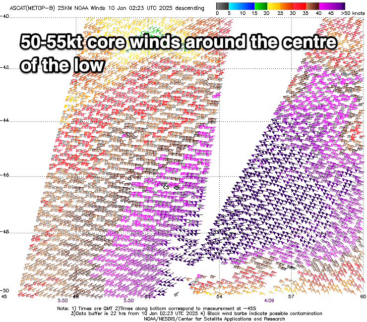
The first swell for the coming days was generated by strong low that fired up to the south-east of South Africa late last week, with fetches of storm-force, 50-55kt winds registered by satellite. The low weakened while projecting east and then up towards and across Western Australia today, with a large, inconsistent SW groundswell due to spread up and into us.
The fore-runners are due to arrive overnight tonight with tomorrow seeing a steady rise in size, likely reaching 6-8ft by late afternoon, with Thursday coming in at 8ft before easing through the day.
The easing trend will slowed through Friday owing to the secondary projection of the low through our swell window yesterday, with a more noticeable easing trend due into the weekend.
Now, the next pulse of large swell is due to arrive strongly through Sunday afternoon, with the source being another storm that fired up to the south-east of South Africa, generating an initial broad fetch of severe-gale W’ly winds. This progression will be slow moving with a fetch of gales due to project slowly east-northeast over the coming days and then north-east towards eastern Indonesia while weakening late week.
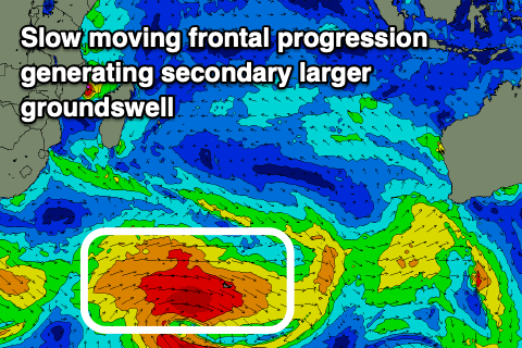
A large, consistent S/SW groundswell will result, pushing above the size of the coming energy later today and tomorrow. It looks to build strongly Sunday afternoon and peak Monday, easing off slowly Tuesday and the more so Wednesday.
Following this we enter a more typical off-season outlook with subdued swell energy for the longer-term.
Local winds will slowly strengthen over the coming days out of the W/NW-NW, strong from late week and into the weekend. Winds look to ease off a touch through next week but we’ll review this Thursday.
Over in the Mentawais, variable winds look to tend a little north-west on the weekend, possibly freshening early next week but check back here on Thursday.
----------------------------------------------
Maldives: Easing levels of SE trade-swell are being seen across most spots, while a strong S’ly groundswell should be filling in across the southern atolls, peaking this afternoon.
This will ease slowly tomorrow, while the secondary frontal progression currently firing up to our south should generate a secondary pulse of larger S’ly groundswell for the weekend.
The swell may be seen late Friday but will peak Saturday, easing slowly Sunday.
Otherwise trade-swell sources look minimal with the surf likely to bottom out in the 1-2ft range for the coming week/weekend.
A renewal of SE trades off the Western Australian coast early next week should produce some new swell later next week but we’ll review this on Thursday.
Winds look to strengthen out of the N tending NE over the coming days across northern and central locations, weaker NW to the south. Winds should then shift more E on the weekend before starting to ease, though likely lingering out of the E/NE.
These local NE winds will kick up some weak NE windswell that will be stronger than the faint SE trade-swell signal.
Eastern Indonesia:
Large SW groundswell building later tomorrow to 6-8ft, peaking Thursday morning to 8ft across exposed breaks, easing later week.
Secondary large S/SW groundswell building later Sunday to 8ft across exposed breaks, peaking Monday to 8-10ft, easing thereafter.
Slowly increasing W/NW-NW winds over the coming days, strong from late week, easing slowly next week.
Uluwatu 16-day Forecast Graph/WAMs
Western Indonesia/Mentawais/South Sumatra:
Large S/SW groundswell building tomorrow afternoon to 8ft later, easing Thursday from a similar size.
Secondary large S/SW groundswell for Sunday, reaching 8ft+ through the day, easing slowly Monday.
Variable winds (NW tendency on the weekend), freshening from the NW early-mid next week.
Mentawai 16-day Forecast Graph/WAMs
Maldives:
Fading SE trade-swell with a small NE windswell for the coming days and weekend.
Moderate + sized S’ly groundswell reaching 4-5ft across the southern atolls through this afternoon, easing slowly tomorrow.
Secondary moderate to large S’ly groundswell for later Friday but peaking Saturday to 5-6ft across the southern atolls, easing slowly Sunday.
Strengthening N tending NE winds over the coming days across northern and central locations, weaker NW to the south. E winds on the weekend, easing slowly and lingering out of the E/NE next week, variable to the south.
Comments
Latest notes are live.
How do you think this will compare the mid-December swell that hit WA lit up Indo Dec 17-19?
Doesn't look as big. At least thats what the charts are saying
Thanks Craig , had some head high to overhead glass walls this morning to myself at sparrows fart , managed to get 6 waves before the crowd descended. Looking forward to the coming week .
Nice one Supa, I scored similar one morning in NL in early October. Could not believe it.
I’m on east coast Bali, came over yesterday arvo , weather has come good , beautiful day and possibly a run of good weather. Things change so quickly however.
Im so disappointed locked and loaded then fell down.
What’s the prognosis evo ? Blown disc ?
There seemed to be some 22-24 second period in the water just now. Either that or different one wave sets were breaking every 23ish seconds.
That was likely the fore-runners arriving.
It was for sure, its bombing now, but long lulls
Wave height doesn't seem to have changed much since dawn. The big sets have had a lot of waves, mostly between 6 and 8 foot, some have been 10 foot.
Thanks for the reports Pottah!
No probs, obvs. talking about the (big) swell magnets. A lot of places were 2-3 foot