Fun weekend, strong swell early next week
Southern Tasmanian Surf Forecast by Craig Brokensha (issued Friday December 23rd)
Best Days: Early tomorrow, Sunday morning, Monday morning, Tuesday, Wednesday morning
Features of the Forecast (tl;dr)
- Small W/SW swell easing tomorrow with early W/NW tending W/SW winds, then fresher SW
- New W/SW swell Sun with variable tending S/SE-SE winds
- Moderate sized W/SW groundswell building Mon PM with N/NE tending SE winds
- Easing W/SW groundswell Tue with N/NE tending E/NE winds
Recap
Tiny waves yesterday, while today a new inconsistent W/SW groundswell has filled in with variable winds. Fun though inconsistent 2ft sets are on offer but the sea breeze is now freshening.

Fun bumpy sets mid-late AM today
This weekend and next week (Dec 24 - 30)
We’ll see today’s inconsistent swell easing back from 2ft on the sets tomorrow morning and conditions should be clean early with a W/NW breeze, deteriorating as winds freshen from the W/SW mid-morning and shift SW.
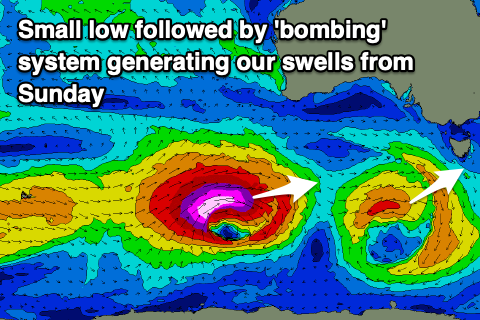
This will be linked to a low pushing in from the west, generating a fun mid-period W/SW swell for Sunday. A fetch of strong to gale-force winds are being projected east through our swell window, with the swell due to come in 2ft+ on Sunday with variable winds ahead of S/SE-SE sea breezes.
Moving into Monday, we’ll see the surf starting slow and to 1-2ft or so with a NE wind, but into the afternoon, a strong increase in W/SW groundswell is due from a ‘bombing’ low that’s formed east of the Heard Island region.

The catalyst for the ‘bombing’ low was a tropical depression being dragged south-east, into the westerly storm track from between Madagascar and South Africa. It’s dropping more than 24hPa within a 24 hour period and we’re seeing a great storm-force fetch of W/SW-W winds being projected east.
The low will maintain its strength into this evening before slowly weakening tomorrow, maintaining severe-gales in our swell window.
The significant fetch strength, track and captured fetch scenario will result in a strong pulse of W/SW groundswell that will build rapidly into Monday afternoon after arriving mid-late morning.
Building sets to a strong 4ft are due through the afternoon but with sea breezes, best Tuesday morning with easing 3ft + waves and a N/NE tending stronger E/NE breeze.
The swell will then ease back through the rest of the week with no much to follow up into the weekend besides a tiny W/SW swell. More on this Monday though. Have a happy and Merry Christmas!


Comments
Another nice wrap up Craig. It's looking good. Merry Christmas mate!
Cheers Horace! You too.