Fun weekend down South

South Australian Forecast by Craig Brokensha (issued Friday January 3rd)
Best Days: Today, tomorrow morning South Coast, tomorrow Mid Coast, Sunday morning South Coast, Wednesday morning South Coast
Features of the Forecast (tl;dr)
- Easing mix of W/SW-SW swell and moderate sized, reinforcing SW groundswell for tomorrow AM, easing
- N/NE tending N/NW then W/NW winds tomorrow, SW into the mid-late PM and possibly variable late
- Smaller Sun AM with variable winds, giving into sea breezes ahead of a stronger S/SW change late PM
- Small W/SW swell Sun PM, easing Mon with strong S-S/SE winds
- Poor S/SE windswell down South Mon, easing Tue with gusty E/SE tending S/SE winds
- Smaller Wed with NE tending S/SE winds
Recap
There was tragic news out of Streaky Bay last night following another shark attack. Thoughts go out to family, friends, local community and greater South Australian surfing community.
The Mid Coast continued to offer fun waves in the 2ft+ range with clean conditions most of the day while the South Coast was a bit cleaner than expected through the morning along with solid 4ft surf, building further into the afternoon but with sea breezes.
This morning we’ve still got 2ft sets across the Mid Coast under a light offshore wind, with lumpy 3-5ft waves across Middleton that is now on the ease. Sea breezes will kick in this afternoon but without much strength.
This weekend and next week (Jan 4 - 10)

Tomorrow looks great for the South Coast with a mix of easing energy from today, backed up by a reinforcing SW groundswell generated by a tight low that moved through our swell window the last couple of days.
This should provide 3ft to occasionally 4ft sets across Middleton early, easing through the day while the Mid Coast drops from a slow 1-2ft on the favourable parts of the tide.
Winds are tricky but look N/NE tending N/NW and then W/NW across the South Coast ahead of a temporary S/SW change that might tend variable into the evening. The Mid should be OK as well with light winds from the NE to NW, variable later.
Sunday looks fun as well with variable morning winds, giving into weak afternoon sea breezes ahead of a stronger S/SW change into the evening.
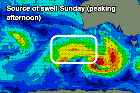
There should be a small pulse of mid-period W/SW swell energy for the afternoon, generated by a trailing front spawning off the back of small low forming south of our swell window today. It doesn’t look to top 2ft+ across Middleton into the afternoon with 1-1.5ft sets across the Mid Coast, easing from a similar size Monday morning.
High pressure will slide in behind Sunday evening’s trough, bringing strong S-S/SE winds on Monday and some localised windswell across the South Coast (wind affected tiny waves inside the gulf), easing Tuesday with fresh to strong E/SE tending S/SE-SE winds.
Wednesday looks cleaner as winds shift back to the NE but only a small mix of easing S/SE windswell and background swell are due to 2ft max, easing through the day.
There’s no decent swell due into the end of the week and the longer term appears to be a return to a more typical summer outlook with winds out of the south-eastern quadrant along with no major surf.
Therefore make the most of the current swell and weekend waves. Have a great weekend!
Comments
Hey mate How do I find out about when the CDC wave buoy gonna be back online ?
No exact timeline, but hopefully soon..
https://www.abc.net.au/news/2024-12-18/broken-bureau-of-meteorology-wave...
Thanks mate !