Poor weekend for the South Coast, surfable on the Mid
South Australian Forecast by Craig Brokensha (issued Friday September 13th)
Best Days: This morning Mid Coast, tomorrow Mid Coast, South Coast Tuesday
Features of the Forecast (tl;dr)
- Moderate sized W/SW-SW groundswell building this afternoon, peaking tomorrow AM, easing
- Strong S/SE winds Sat (lighter E/SE-SE on the Mid in the AM), strong E/SE tending S/SE Sun
- Smaller surf Mon with E/NE-NE tending SE winds
- Moderate sized mix of S/SW groundswell and mid-period energy Tue with N/NW tending W/NW winds
- Larger, windier surf building mi9-late week
Recap
The Mid offered tiny 1-1.5ft waves yesterday while the South Coast was onshore but doable into the afternoon as winds eased.
Today, a new W/SW-SW swell that’s due to build into the afternoon looks to be in the water already across the Mid Coast with slow but clean 1-2ft sets, only 2ft+ or so across Middleton on the South Coast with variable onshore winds.
Sea breezes will freshen into the afternoon across both regions as the swell builds more down South with no real offshore wind due on the Mid Coast until after dark.

Bomb set this morning inside the gulf
This weekend and next week (Sep 14 - 20)
There’s been no change to the wind outlook for the weekend across the South Coast, with an overnight change due to leave strong S/SE winds into tomorrow morning along with a peak in SW groundswell.
The Mid Coast looks cleaner and with 2ft sets while Middleton should come in at 4-5ft but with those poor winds.
Sunday looks smaller, and tiny across the Mid Coast with fresh to strong E/SE tending S/SE winds.
Our lighter E/NE-NE winds for Monday morning are still on track but following a whole weekend of onshore breezes, the South Coast will be lumpy and not ideal with peaky weak waves to 2-3ft (tiny on the Mid Coast).

Into Tuesday, better N/NW tending W/NW winds are expected along with a new, inconsistent S/SW groundswell.
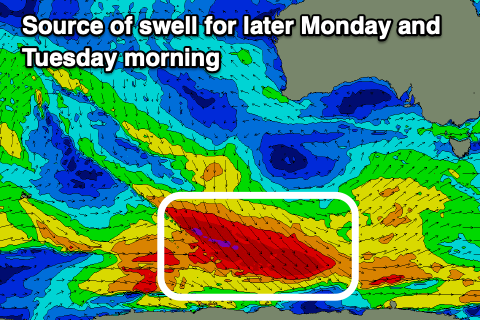
This will be generated by a fetch of severe-gale W/NW winds projecting down along the polar shelf today and under us tomorrow but tending more NW and away from us. While not ideally aimed, we should see the swell spreading radially up into us with a late increase Monday, peaking Tuesday morning to 3ft+ across Middleton.
Following this, we’re looking at the start of a great looking Southern Ocean frontal progression firing up under the country mid next week, focussing towards Victoria and Tasmania.

The strength and make up of each front is still yet to be settled, but we’re due to see back to back to back fetches of gale to severe-gale W/SW winds firing up through our swell window, generating moderate to large pulses of SW groundswell from Thursday through next weekend and early the following week.
At this stage the largest pulses are due Friday and Saturday afternoon/Sunday along with winds from the western quadrant. There should be pockets of clean conditions around Victor but we’ll review this Monday. Have a great weekend!

