Average outlook ahead, with a return to frontal action later next week
South Australian Forecast by Craig Brokensha (issued Wednesday September 11th)
Best Days: Mid Coast for the desperate Saturday morning, South Coast Tuesday morning
Features of the Forecast (tl;dr)
- Weak mix of swells tomorrow with S/SE winds, increasing
- Moderate sized SW groundswell building late Fri PM, peaking Sat AM
- Variable winds Fri AM, tending onshore from the SW-S/SW and freshening
- Strong S/SE winds Sat, strong E/SE-SE Sun
- Smaller surf Mon with E/NE tending SE winds
- Moderate sized mix of S/SW groundswell and mid-period energy Tue with N/NE tending SE winds
- Larger, windier surf late next week
Recap
Our less consistent but good W/SW swell provided fun 2ft+ waves most of yesterday across the Mid Coast with favourable conditions as winds finally backed off, while the South Coast came in around 3ft+.
Today, the swell is smaller and to 1-1.5ft inside the gulf, still 3ft across Middleton and early light winds will give into a stronger S/SW-S change as a trough moves through.

Glassy offerings yesterday afternoon
This week and next (Sep 12 - 20)
All good things must come to an end, for now.
Our good run of swell for the Mid Coast and favourable conditions down South will come to an end today as the trough brings a strong S’ly change.
This trough will clear quickly to the east allowing winds to ease and tend S/SE tomorrow morning. The South Coast will be bumpy and onshore with a mix of swells to 2-3ft, with the Mid Coast coming in cleaner but tiny.
Into Friday, winds are due to shift more SW, with an early W/NW’ly likely across Victor, SE inside the gulf but with small levels of swell energy as we reach a low point.

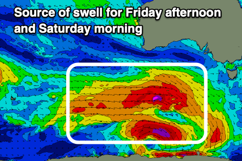
Later in the day but more so Saturday morning, we should see a moderate + sized SW groundswell filling in, with a strong, broad low currently to the south-west of Western Australia being the source.
The low will be a little disjointed regarding fetch generation, with prefrontal gale to severe-gale NW tending W/NW winds due to then be followed by gale to severe-gale W’ly winds, moving more into our south-western swell window while weakening tomorrow.
There’ll also be storm-force W/NW winds at the base of the low, though very small in scope and not aimed well at all.
Overall the strength of the system has been upgraded a little, with building sets towards 4ft due late Friday on the Surf Coast but with a moderate to fresh S/SW breeze, peaking Saturday morning to 4-5ft across Middleton, easing through the day.
The Mid Coast may see slow, inconsistent 1-2ft sets late Friday and Saturday morning but otherwise it’ll be tiny.
Unfortunately conditions are still looking poor for this swell as a high moves in from the west, bringing strong S/SE winds Saturday, strong E/SE tending SE on Sunday as the swell eases.
Winds are due to ease and tend lighter E/NE on Monday morning but with lots of lump down South along with 2-3ft leftovers.
Now, into Tuesday, a good pulse of S/SW groundswell is due, generated by a polar fetch of severe-gale W/NW winds sliding under the country Friday and Saturday.

Size wise, it looks to be small to moderate in size, while secondary frontal activity moving under the state early next week should produce some additional close-range energy on top.
At this stage, Middleton could see surf to 3ft+, tiny inside the gulf along with variable morning offshore winds. We’ll have a closer look this Friday.
Longer term we’ve got a re-strengthening of the westerly storm track south of the country mid-late next week, generating another good run of moderate to large surf from late week into next weekend. More on this Friday.

