Windows for the Mid Coast with endless west energy
South Australian Forecast by Craig Brokensha (issued Friday September 6th)
Best Days: South Coast all period besides Thursday and Friday, Mid Coast tomorrow afternoon, Tuesday and Wednesday
Features of the Forecast (tl;dr)
- Moderate sized W swell building today
- Moderate sized SW groundswell for later today and dawn tomorrow, easing
- Moderate NW tending W/NW winds tomorrow (easing inside the gulf later)
- Moderate + sized pulses of W/SW swell from Sat PM through Tuesday (biggest down South Monday)
- Strengthening W/NW-NW tending W/NW winds Sun
- Fresh but easing W/SW winds Mon (W/NW for a period down South)
- E/NE-NE tending light N/NW winds Tue inside the gulf, N/NW tending variable down South
- Easing swell Wed with variable offshore winds ahead of sea breezes
- Smaller Thu with strong S/SE-SE winds
Recap
Yesterday started slow and funky with north winds and tiny surf inside the gulf ahead of a variable breeze and new pulse of W/SW groundswell to a good 2ft+ through the afternoon. This morning an early change created bumpy conditions but winds sinced eased, allowing the surf to clean up but we’re now seeing conditions deteriorate again with a more pronounced change.
The South Coast also offered fun waves all day yesterday with 2-3ft of inconsistent but great swell, similar today but with early onshore tending offshore winds.

Our new swell with light winds yesterday afternoon
This week and next (Sep 7 - 13)
The coming period remains very active from the west with a stream of swell generating systems pushing initially up and across Western Australia, followed by more southerly located fronts pushing towards us over the weekend.

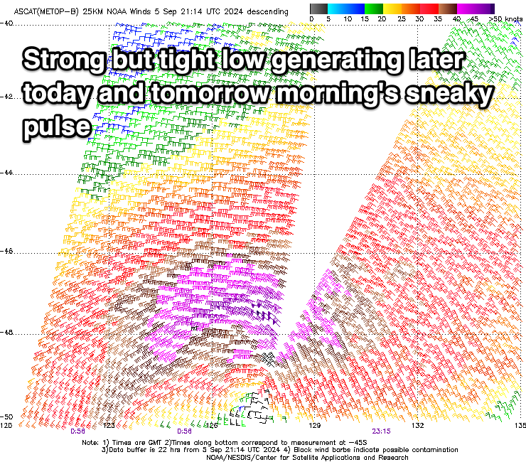
Firstly though for later today and early tomorrow, a small, tight low has generated a short-lived, sneaky pulse of SW swell that should come in at 3ft to possible 4ft across Middleton, with the Mid Coast holding the 2ft range on the sets. The satellite imagery from this low is impressive (shown left).
This swell will ease through the day and moderate NW tending W/NW winds will create great conditions for the South Coast with bumps on the Mid, possbily cleaning up late as winds ease off a little.
Later in the day Saturday and Sunday, a distant W/SW swell is due along with some closer-range W/SW swell through Sunday afternoon and more so into Monday.
The source of the long-range energy was a strong, northward projecting frontal progression that pushed across Western Australia the last couple of days. This swell will coincide with closer-range energy from a healthy front passing under the country on the weekend.
The Mid Coast looks to come in at 2-3ft from Sunday through Tuesday, with the South Coast build back towards 3ft+ Sunday with a peak to 4ft on Monday across Middleton.

Also in the mix will be some additional long-range W/SW swell Monday afternoon and Tuesday, generated by a healthy trailing polar front currently projecting towards us to the south-west of Western Australia. This will help maintain those good sized sets across the Mid Coast with 3-4ft waves down South.
Local winds will continue to add bumps across the Mid Coast with Sunday seeing strengthening W/NW-NW tending W/NW winds, followed by fresh W/SW winds Monday, tending W/NW for a period down South.
Tuesday looks the pick for the Mid Coast with variable E/NE-NE winds (N/NW down South), tending light N/NW inside the gulf after lunch and variable down South.
A slow easing trend is then due from Wednesday with variable offshore winds across both coasts ahead of sea breezes and then a trough Thursday/Friday which will bring stronger S/SE-S winds, something we haven’t seen for a while. Therefore make the most of the coming run of waves and good conditions. Have a great weekend!

