Lots of swell this week, cleanest in protected spots
South Australian Forecast by Craig Brokensha (issued Monday 11th September)
Best Days: South Coast Tuesday, protected breaks Thursday morning, Friday
Recap
Good fun waves Saturday with plenty of size and cleaner conditions down South with a variable tending light offshore wind. Sunday was excellent with all day offshores and fun easing surf from the 2-3ft range across the Middleton stretch.
The Mid Coast was tiny, becoming near flat yesterday and today. The South Coast also bottomed out into this morning with clean but tiny waves, best suited to swell magnets.
This week and weekend (Sep 12 - 17)
Tomorrow's good new SW groundswell is on track, with it being generated late last week and into Saturday by a strong polar low south-west of WA.
 The system weakened while slowly moving east closer towards us, so this should help keep the consistency of the swell reasonable.
We should see great 3-4ft sets across Middleton all of tomorrow, larger at Waits and Parsons, while the Mid Coast should be around 1ft, with 1.5ft sets on the favourable parts of the tide.
Conditions should be great down South in the morning with a N/NW offshore, tending W/NW and strengthening with an approaching mid-latitude front.
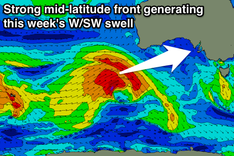
This mid-latitude front is currently south-west of WA, projecting a great fetch of W'ly gales through our western swell window. The front will weaken slightly tomorrow while continuing east through the Bight and across us Wednesday.
A strong fetch of W/SW winds will kick up a semi-stormy increase in W/SW swell through the day, coming in around 3ft on the Mid Coast, while the South Coast should see messy surf building to the 3-5ft range.
The groundswell proper is due overnight, peaking Thursday morning to a similar 3ft on the Mid Coast and 4-6ft off Middleton. A drop in size is expected through the day, further into Friday.
 Winds Wednesday are due to be fresh from the W/SW, strengthening from the SW through the afternoon (with a possible period of W'ly winds around Victor).
Thursday should be cleaner in protected spots down South with a W/NW tending W/SW breeze and then NW-W/NW winds Friday.
Into the weekend, a fairly benign mid-latitude front is forecast to deepen significantly while passing under is Friday, with a fetch of severe-gale S/SW winds due to be projected through our southern swell window.
If this low develops as forecast, a moderate to large sized S/SW groundswell will result for Saturday, but with onshore S'ly winds in the wake of the low. We may see conditions improve Sunday on the backside of the low, but more on this Wednesday.

