Fun S'ly tending SE swell through the period
Eastern Tasmania Surf Forecast by Craig Brokensha (issued Monday 1st August)
Best Days: Wednesday morning, Thursday morning, Friday morning, Saturday morning, Sunday morning
Recap
Tiny waves at open beaches Saturday but a bit bigger at south magnets, easing back through Sunday.
Today was expected to be tiny, but southerly groundswell lines to 2-3ft were reported, the source a little hard to pin down, with the South Arm being so tiny.
This week (Aug 2 - 5)
The dynamic setup that was forecast to develop by all models late last week has changed quite a bit.
A deepening cut-off low now is forecast to develop further east and away from us in the Tasman Sea, with a strengthening fetch of strong to gale-force S/SW winds off our coast tomorrow producing a building S'ly windswell through the day, reaching 2-3ft or so across south facing beaches, holding a bigger 3ft to possibly 4ft through Wednesday.
 As the low forms over near New Zealand a better fetch of SE gales on the edge of our swell window should produce a fun E/SE groundswell for Thursday afternoon and Friday morning to 3-4ft.
Conditions each morning are looking good with W/SW offshores, more S/SW Tuesday afternoon, S/SE Wednesday afternoon and then SE Thursday afternoon. Friday could then see variable breezes.
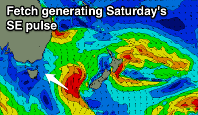
Into the weekend a new pulse of strong S/SE groundswell is due, generated by a polar front projecting up through the southern Tasman Sea on Thursday evening and Friday.
This will produce a fetch of S'ly gales through our southern swell window, with the groundswell building Saturday and peaking to 3-4ft and then easing back Sunday. Conditions look great again through the mornings, with onshores into the afternoons.
Longer term some small N/NE windswell is on the cards for next week, but we'll review this Wednesday.

