Initially, winds on the Western (East Coast Aus) side of the Tasman begin to freshen from the North and we’ll see that through the rest of the working week as the high pressure ridge gets squeezed by an approaching trough and front.
Primary tabs
/reports/forecaster-notes/eastern-tasmania/2021/09/01/chunky-ne-swell-expected-weekend-more-s-swell
freeride76
Wednesday, 1 September 2021
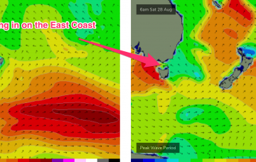
/reports/forecaster-notes/eastern-tasmania/2021/08/30/active-tasman-sea-swell-the-ne-and-ene-incoming
freeride76
Monday, 30 August 2021
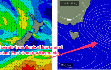
N’ly winds then freshen again Thursday with a much stronger fetch adjacent to the NSW coastline and extending down to the Tasmanian coast brings a stronger flush of NE windswell.
/reports/forecaster-notes/eastern-tasmania/2021/08/27/active-weekend-tasman-low-more-swells-next-week
freeride76
Friday, 27 August 2021
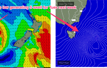
Remnants of this weeks Tasman low are expected to drift NE towards the North Island over the weekend and reintensify Sun/Mon with a fetch of severe gales extending out of Cook Strait into the Tasman Sea.
/reports/forecaster-notes/eastern-tasmania/2021/08/25/slow-moving-tasman-low-swell-producer-the
freeride76
Wednesday, 25 August 2021
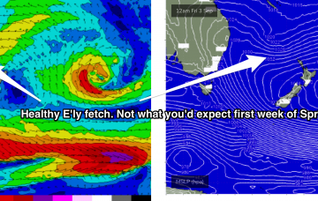
Strong swell from the SE/ESE being generated by the SW flank of the low as it drifts towards the South Island should see plenty of surf in the 5ft range, holding into Sat before easing back.
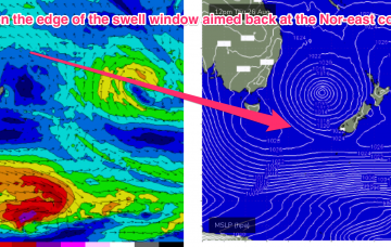
/reports/forecaster-notes/eastern-tasmania/2021/08/23/tasman-low-brings-wind-and-swell-east-coast
freeride76
Monday, 23 August 2021
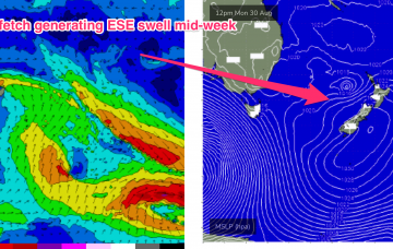
Friday looks a much better bet. With the low drifting SE towards New Zealand the south and south-west flank of the low aim a fetch of SE/ESE winds back at the North-east coastline of Tasmania.
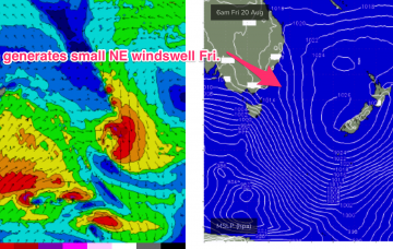
/reports/forecaster-notes/eastern-tasmania/2021/08/20/tiny-weekend-some-surf-potential-tasman-low
freeride76
Friday, 20 August 2021
The low drifts away towards New Zealand through Wed/Thurs with SE winds on the lower flank of the cut-off low sufficiently low in latitude to be in the Nor-east Tas swell window
/reports/forecaster-notes/eastern-tasmania/2021/08/18/slim-pickings-ahead-flush-small-ne-windswell
freeride76
Wednesday, 18 August 2021
Not much on the menu with small, weak swells from the north-east.
/reports/forecaster-notes/eastern-tasmania/2021/08/16/strong-s-swell-the-build
freeride76
Monday, 16 August 2021
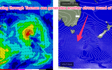
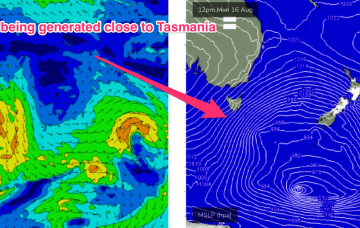
Todays passage of a polar low with a favourably angled SSW fetch now slingshotting into Tasmanian latitudes is generating a solid S swell building into this evening.
/reports/forecaster-notes/eastern-tasmania/2021/08/13/plenty-more-s-swell-early-next-week
freeride76
Friday, 13 August 2021
Eastern Tasmania Surf Forecast by Steve Shearer (issued Fri 13 August)
Features of the Forecast (tl;dr)
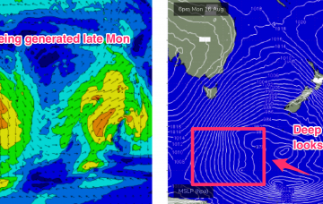
- Small S swell Sat as polar low passes under Tas Fri
- Slow moving low provides S swell pulse late Mon, peaking Tues, leftovers Wed
Recap
Small amounts of NE windswell in the 1-2ft range provided some just rideable surf Thursday. Swell from this source has eased back but with a few tiny waves available at NE facing beaches.
/reports/forecaster-notes/eastern-tasmania/2021/08/11/stronger-s-swell-the-menu-early-next-week
freeride76
Wednesday, 11 August 2021
With severe gales extending from Tasmania down to 55S and a slightly more favourable SSW tilt in the winds which then push up adjacent to SE Tasmania during Tues..