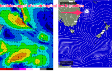
This is maintaining the ridge of high pressure along most of the East Coast, with a slight and slow easing of pressure gradients expected over the weekend. An active Monsoon Trough lays across the North of the Continent extending out into the Coral Sea.
Primary tabs
/reports/forecaster-notes/south-east-queensland-northern-new-south-wales/2022/01/21/period-light
freeride76
Friday, 21 January 2022
/reports/forecaster-notes/south-east-queensland-northern-new-south-wales/2022/01/19/another-round
freeride76
Wednesday, 19 January 2022
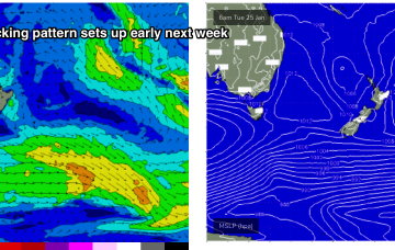
A classic Summer blocking pattern is now setting up with a slow moving high drifting well south of Victoria and a series of troughs interacting with a strong high pressure ridge which has reached Central NSW and is now building into more sub-tropical regions.
/reports/forecaster-notes/south-east-queensland-northern-new-south-wales/2022/01/17/more-ese-swell-ex
freeride76
Monday, 17 January 2022
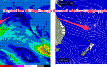
Ex TC Cody slipped behind the North Island late this weekend and is now slowly drying up as a swell source. Due to the slow moving nature of the system as it approached the North Island there’s still some more solid surf to come, with a final pulse of E/SE swell expected Wed.

/reports/forecaster-notes/south-east-queensland-northern-new-south-wales/2022/01/14/lots-size-ahead
freeride76
Friday, 14 January 2022
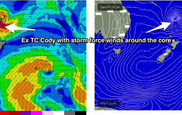
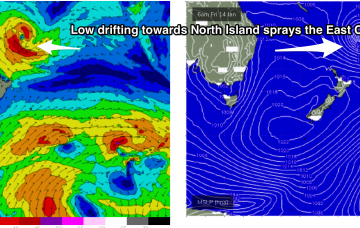
The low (Ex TC Cody) is drifting slowly south-southeastwards towards the North Island with an extensive swath of storm force (50knot) winds along the south-western flank. These storm forces winds are embedded in an expansive gale force wind field.
/reports/forecaster-notes/south-east-queensland-northern-new-south-wales/2022/01/12/tc-cody-drifting
freeride76
Wednesday, 12 January 2022
Current ASCAT (satellite windspeed) passes show a healthy fetch of E’ly winds flanking TC Cody as drifts south/south-east of the area between Fiji and New Caledonia towards the North Island.

/reports/forecaster-notes/south-east-queensland-northern-new-south-wales/2022/01/10/extended-ely
freeride76
Monday, 10 January 2022
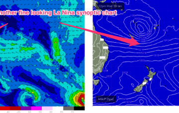
Our current synoptic pattern is typical of the season and the La Nina end of the ENSO cycle. High pressure straddles New Zealand and a tropical low now drifting south from between Fiji and Vanuatu.
/reports/forecaster-notes/south-east-queensland-northern-new-south-wales/2022/01/07/another-extended
freeride76
Friday, 7 January 2022
By Tues the wave climate will come more under the direct influence of the tropics, with a broad Tradewinds band being accelerated by a tropical low drifting South from area between Fiji and Vanuatu.
/reports/forecaster-notes/south-east-queensland-northern-new-south-wales/2022/01/05/lots-more-ely
freeride76
Wednesday, 5 January 2022
The sub-tropical high pressure belt also extends Eastwards of New Zealand and the cradling effect of this belt along the low pressure zone is expected to create a long fetch of enhanced Tradewinds during next week.
/reports/forecaster-notes/south-east-queensland-northern-new-south-wales/2022/01/03/slow-easing
freeride76
Monday, 3 January 2022
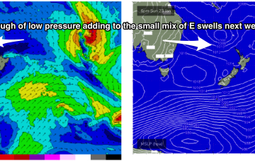
More action in the tropics next week. Later this week another tropical low is expected to form in the South Pacific- possibly between Fiji and Vanuatu.

/reports/forecaster-notes/south-east-queensland-northern-new-south-wales/2021/12/31/pumping-surf-the
freeride76
Friday, 31 December 2021
A tropical hybrid low is now tracking SE down the Coral Sea, roughly parallel to the QLD coast. This will bring plenty of solid swell to the f/cast region over the short term