This is maintaining the ridge of high pressure along most of the East Coast, with a slight and slow easing of pressure gradients expected over the weekend.
Primary tabs
/reports/forecaster-notes/sydney-hunter-illawarra/2022/01/21/small-surf-next-week-tame-summer
freeride76
Friday, 21 January 2022
/reports/forecaster-notes/sydney-hunter-illawarra/2022/01/19/summer-blocking-pattern-maintains-se
freeride76
Wednesday, 19 January 2022
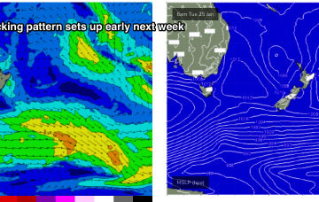
A classic Summer blocking pattern is now setting up, with a slow moving high drifting well south of Victoria and a series of troughs interacting with a strong high pressure ridge which has reached Central NSW and is now building into more sub-tropical regions.
/reports/forecaster-notes/sydney-hunter-illawarra/2022/01/17/ely-groundswell-replaced-plenty-short
freeride76
Monday, 17 January 2022
A trough brings a S’ly change tomorrow , with another strong high tracking south of the Bight poised to be the main weather feature this week.

/reports/forecaster-notes/sydney-hunter-illawarra/2022/01/14/strong-pulses-ex-tc-cody-the-radar-some
freeride76
Friday, 14 January 2022
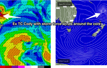
TC Cody is the main game in town and the system has now undergone extra-tropical transition and is classified as a storm force sub-tropical low.
/reports/forecaster-notes/sydney-hunter-illawarra/2022/01/12/pulsey-e-swell-tc-cody-extends-the
freeride76
Wednesday, 12 January 2022
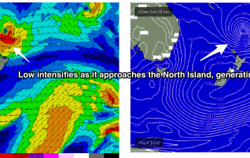
Current ASCAT (satellite windspeed) passes show a healthy fetch of E’ly winds flanking a tropical low as drifts south of the area between Fiji and New Caledonia towards the North Island.
/reports/forecaster-notes/sydney-hunter-illawarra/2022/01/10/extended-run-e-swell-ahead-some-windows
freeride76
Monday, 10 January 2022
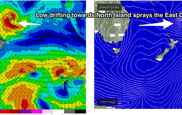
Our current synoptic pattern is typical of the season and the La Nina end of the ENSO cycle. High pressure straddles New Zealand and a tropical low now is drifting south from between Fiji and Vanuatu towards the North Island.
/reports/forecaster-notes/sydney-hunter-illawarra/2022/01/07/more-swell-the-ene-incoming-next-week
freeride76
Friday, 7 January 2022
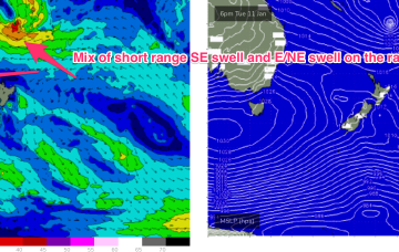
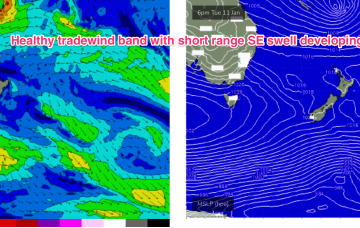
By Thurs the wave climate will come under the influence once more of the tropics, with a broad Tradewinds band being accelerated by a tropical low drifting South from area between Fiji and Vanuatu.
/reports/forecaster-notes/sydney-hunter-illawarra/2022/01/05/surf-slowly-easing-the-ene-onshore-winds
freeride76
Wednesday, 5 January 2022
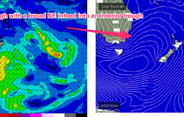
A strong high is now slipping in underneath Tasmania and the combination of the decaying ex cyclone, developing high pressure ridge and an interior trough is creating a long, broad fetch E/NE winds extending from New Caledonia down into the Central Tasman Sea.
/reports/forecaster-notes/sydney-hunter-illawarra/2022/01/03/lots-swell-and-wind-the-ene-ne-week
freeride76
Monday, 3 January 2022
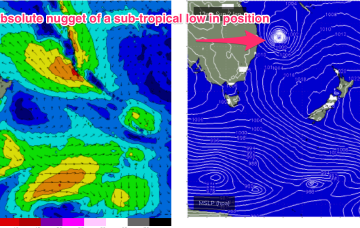
Swell from ex TC Seth, which transitioned into a gale force sub-tropical low Sun is the major synoptic feature this week, responsible for both swell production and directing gradient winds as it slowly weakens and meanders close to the NENSW/SEQLD coast for the next few days.
/reports/forecaster-notes/sydney-hunter-illawarra/2021/12/31/lots-surf-the-ene-e-next-week-tropical
freeride76
Friday, 31 December 2021
While there is still a bit of model variance the broad scale pattern is clear enough to make a high confidence call on Mon seeing a significant pulse of E/NE groundswell across the region.