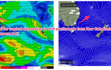
A tropical depression between Vanuatu and New Caledonia has formed a tropical cyclone (TC Tam) and is racing south-eastwards at 23kts, where it is expected to merge with another tropical low SW of New Caledonia. After a binary interaction between the two systems, the merged low transitions into a storm force sub-tropical low which tracks SW into the Northern Tasman.
Primary tabs
/reports/forecaster-notes/sydney-hunter-illawarra/2025/04/16/large-e-swell-ahoy-good-friday
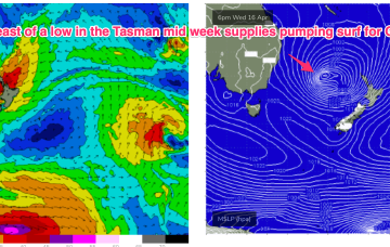
freeride76
Wednesday, 16 April 2025
/reports/forecaster-notes/sydney-hunter-illawarra/2025/04/14/dynamic-week-ahead-pumping-surf-likely
freeride76
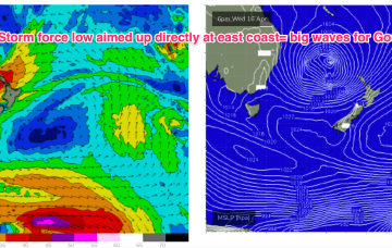
Monday, 14 April 2025
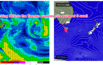
Certainly by Thurs the synoptic chart should look insane with a deep low (970-980hPa) retrograding into the Tasman, positioned inside the North island with plenty of space for severe gale to low end storm force winds to be aimed up at the east coast.
/reports/forecaster-notes/sydney-hunter-illawarra/2025/04/11/fun-weekend-small-waves-interesting
thermalben
Friday, 11 April 2025
It's a bit of a tricky weekend of waves, but the short version is there should be something fun and it’ll be clean on top.
/reports/forecaster-notes/sydney-hunter-illawarra/2025/04/09/small-in-the-short-term-some-exciting
freeride76
Wednesday, 9 April 2025
High pressure is moving into the Tasman, strengthening as it drifts towards New Zealand, where it is expected to become a dominant “flat topped” feature, reinforced by subsequent high pressure moving into the Tasman. We’ll see a long E’ly fetch develop through the South Pacific slot through the end of this week, enhanced by a trough of low pressure near New Caledonia which is attached to a still active monsoon trough.
/reports/forecaster-notes/sydney-hunter-illawarra/2025/04/07/chunky-the-s-short-term-fun-mixed-bag
freeride76
Monday, 7 April 2025
A front passes into the Tasman overnight and robust fetch of SW gales is trailing behind, currently sweeping NE past the SE coast of Tasmania.
/reports/forecaster-notes/sydney-hunter-illawarra/2025/04/04/nice-run-south-swells-we-look-the-east
thermalben
Friday, 4 April 2025
Monday and Tuesday will almost mirror the weekend’s swell pattern, with generally light winds and sea breezes expected both days - so better conditions on the balance.
/reports/forecaster-notes/sydney-hunter-illawarra/2025/04/02/slow-downwards-trend-tasman-low
freeride76
Wednesday, 2 April 2025
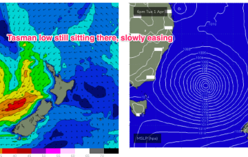
We’ll see the low meander towards the South Island for the remainder of the week, with large swells on the ease across Southern/Central NSW, much less size into the sub-tropics.
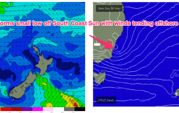
/reports/forecaster-notes/sydney-hunter-illawarra/2025/03/30/pumping-surf-week-becoming-more-user
freeride76
Monday, 31 March 2025
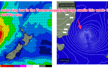
We have a powerful swell generating pattern in place with a deep low (993hPa) in the Tasman, supported by a large high (1033hPa) well to the south of the Bight.
/reports/forecaster-notes/sydney-hunter-illawarra/2025/03/27/significant-l-xl-s-swell-now-the-radar
freeride76
Friday, 28 March 2025
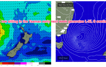
We’re now looking at a very significant S swell early next week as a deep low sits off the South or Gippsland Coast with severe gales to storm force winds aimed into the proximate southern swell window. Concurrently, another Ross Sea ice shelf fetch will be peaking or just post-peak as a massive deep low forms NE of the Ross Sea on the weekend and develops storm force winds.
/reports/forecaster-notes/sydney-hunter-illawarra/2025/03/26/plenty-potential-the-ne-tropical-trough
freeride76
Wednesday, 26 March 2025
It’s likely we will see remnants of the inland monsoon low approach the SEQLD/NSW Coast during the weekend, dragging a moist NE flow down from the tropics and creating a mini black nor-easter event.