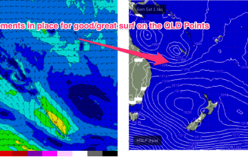
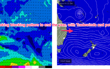
Surf prospects from this low are now confirmed as excellent with major weather models expecting the system to track parallel to the East Coast, spraying the region with swell as it does so and, possibly reforming as a significant extra-tropical storm in the lower Tasman Sea next week.
Primary tabs
/reports/forecaster-notes/south-east-queensland-northern-new-south-wales/2021/12/29/pumping-surf
freeride76
Wednesday, 29 December 2021
/reports/forecaster-notes/south-east-queensland-northern-new-south-wales/2021/12/27/extended-period
freeride76
Monday, 27 December 2021
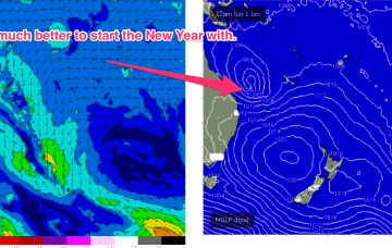
In the tropics the Monsoon trough is now active, with good odds of cylogenesis occurring before the New Year and plenty of surf ahead.
/reports/forecaster-notes/south-east-queensland-northern-new-south-wales/2021/12/24/tropics-slowly
freeride76
Friday, 24 December 2021
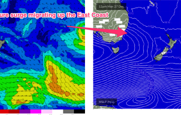
Models have invested in the start of the Northern Australian Monsoon (NAM) as the year ends, suggesting a tropical low tracking across the Northern Territory into the Gulf of Carpenteria and then across Cape York Peninsula into the Coral Sea towards the end of next week.
/reports/forecaster-notes/south-east-queensland-northern-new-south-wales/2021/12/22/small-weak-surf
freeride76
Wednesday, 22 December 2021
Very weak pressure gradients everywhere as we continue to meander through this troughy, doldrums pattern. Plenty of action ahead next week.
/reports/forecaster-notes/south-east-queensland-northern-new-south-wales/2021/12/20/small-bits-and
freeride76
Monday, 20 December 2021
Lots of wind changes and flukey swells ahead this week as a Spring looking pattern unfolds in the week leading up to Xmas.
/reports/forecaster-notes/south-east-queensland-northern-new-south-wales/2021/12/17/lots-interesting
thermalben
Friday, 17 December 2021
Hmm, we’ve got an interesting troughy period next week.
/reports/forecaster-notes/south-east-queensland-northern-new-south-wales/2021/12/15/flukey-swell
thermalben
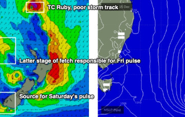
Wednesday, 15 December 2021
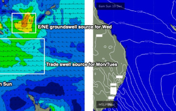
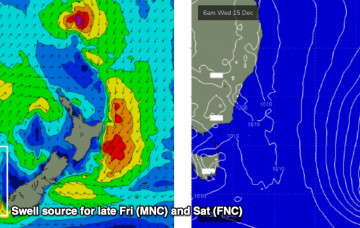
However, we have some new swell due south of the border on Friday. In fact the Lower Mid North Coast may see this late Thursday.
/reports/forecaster-notes/south-east-queensland-northern-new-south-wales/2021/12/13/easing-surf-over
thermalben
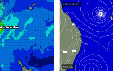
Monday, 13 December 2021
We have some small new swell on the way for the end of the week. Though, one coast will pick it up and the other will miss out.
/reports/forecaster-notes/south-east-queensland-northern-new-south-wales/2021/12/10/lots-fun-days
thermalben
Friday, 10 December 2021
In Wednesday’s forecast I discussed a potential NE cyclone swell.
/reports/forecaster-notes/south-east-queensland-northern-new-south-wales/2021/12/08/fun-surf-ahead
thermalben
Wednesday, 8 December 2021
We have a nice round of east swell on the way, generated by a sub-topical low positioned well NE of New Zealand over the weekend. And a cyclone swell too!