We’ll see steady surf from the east every day, so you’ll just have to work around the local winds.
Primary tabs
/reports/forecaster-notes/south-east-queensland-northern-new-south-wales/2016/12/19/extended-run-fun
thermalben
Monday, 19 December 2016
/reports/forecaster-notes/south-east-queensland-northern-new-south-wales/2016/12/16/choose-your-own
thermalben
Friday, 16 December 2016
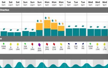
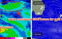
From late Monday or Tuesday onwards, we will also start to see a building E/NE swell originating from a broadening E'ly fetch around the southern flank of TD04F (a tropical depression currently delivering a deluge to Fiji) which may be upgraded to a Category 1 Tropical Cyclone this evening.
/reports/forecaster-notes/south-east-queensland-northern-new-south-wales/2016/12/14/long-term-period
thermalben
Wednesday, 14 December 2016
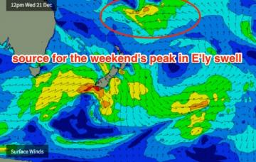
Although the ridge responsible for our small trade swell of the last few days has slowly retreated eastwards, the models are maintaining small levels of east swell from Thursday right through into the weekend.

/reports/forecaster-notes/south-east-queensland-northern-new-south-wales/2016/12/12/extended-pattern
thermalben
Monday, 12 December 2016
There’s a couple of interesting features on the charts but ultimately we’re not looking at any notable surf throughout the next four or five days.
/reports/forecaster-notes/south-east-queensland-northern-new-south-wales/2016/12/09/extended-small
thermalben
Friday, 9 December 2016
So, we’ve got a couple of swells for the weekend.
/reports/forecaster-notes/south-east-queensland-northern-new-south-wales/2016/12/07/fun-weekend-waves
thermalben
Wednesday, 7 December 2016
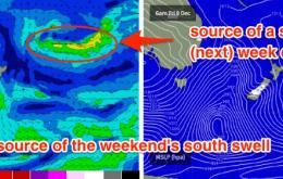
SE Qld will see a small building trade swell, from a ridge that’s expected to strengthen through the Coral Sea. Across Northern NSW, we have a few days of south swell to look forward to.

/reports/forecaster-notes/south-east-queensland-northern-new-south-wales/2016/12/05/flag-working-week
thermalben
Monday, 5 December 2016
The weekend looks OK across SE Qld, and reasonable across Northern NSW.
/reports/forecaster-notes/south-east-queensland-northern-new-south-wales/2016/12/02/episode-v
thermalben
Friday, 2 December 2016
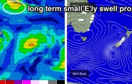
The other area of interest I’ll be keeping a close eye on is a small easterly dip south of Fiji around Monday.
/reports/forecaster-notes/south-east-queensland-northern-new-south-wales/2016/11/30/little-respite
thermalben
Wednesday, 30 November 2016
The models have shifted around since Monday, with regards to Friday’s local wind outlook.
/reports/forecaster-notes/south-east-queensland-northern-new-south-wales/2016/11/28/i-one-welcome-our
thermalben
Monday, 28 November 2016
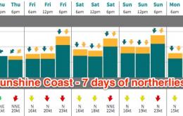
It’s a tricky week ahead for surf forecasting purposes, but there is one underlying theme that will unite us for the next five days. Northerly winds.
