/reports/forecaster-notes/south-east-queensland-northern-new-south-wales/2019/10/04/mediocrity
thermalben
Friday, 4 October 2019
We’ve got a lot of troughiness expected for the next few weeks. More in the Forecaster Notes.
/reports/forecaster-notes/south-east-queensland-northern-new-south-wales/2019/10/02/more-swells-out
thermalben
Wednesday, 2 October 2019
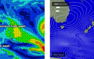
This swell will have been sourced from a more acute part of our swell window, well below the continent so I’m expecting fewer locations to pick up the bulk size, and it’ll be a lot less consistent too. More in the Forecaster Notes.
/reports/forecaster-notes/south-east-queensland-northern-new-south-wales/2019/09/30/small-mix-east
thermalben
Monday, 30 September 2019
Weak easterly swells for SE Qld with fluctuating pulses of southerly swell south of the border.
/reports/forecaster-notes/south-east-queensland-northern-new-south-wales/2019/09/27/broad-mix-swells
thermalben
Friday, 27 September 2019
This forecast period is all about the wind. More in the Forecaster Notes.
/reports/forecaster-notes/south-east-queensland-northern-new-south-wales/2019/09/25/tricky-winds
thermalben
Wednesday, 25 September 2019
Local winds are the big wild card for the next few days. More in the Forecaster Notes.
/reports/forecaster-notes/south-east-queensland-northern-new-south-wales/2019/09/23/tricky-winds-week
thermalben
Monday, 23 September 2019
Fortunately, there’s plenty of swell coming up for Northern NSW, but unfortunately this pattern won’t favour SE Qld very well. More in the Forecaster Notes.
/reports/forecaster-notes/south-east-queensland-northern-new-south-wales/2019/09/20/plenty-swell
thermalben
Friday, 20 September 2019
Northerly winds will create problems all weekend, especially across the Mid North Coast where they’ll be at their strongest. More in the Forecaster Notes.
/reports/forecaster-notes/south-east-queensland-northern-new-south-wales/2019/09/18/easterly-swells
thermalben
Wednesday, 18 September 2019
Fortunately, there are new waves on the way for all coasts. The trickiness is in the local winds. More in the Forecaster Notes.
/reports/forecaster-notes/south-east-queensland-northern-new-south-wales/2019/09/16/complex-week
thermalben
Monday, 16 September 2019
Probably the trickiest part of this week’s forecast - at least for the next few days - are the local winds. More in the Forecaster Notes.
/reports/forecaster-notes/south-east-queensland-northern-new-south-wales/2019/09/13/south-swell
thermalben
Friday, 13 September 2019
We’ve got a couple of south swells in store for the weekend, generated by transient fronts through the lower Tasman Sea. More in the Forecaster Notes.

