Tricky winds this week, with a mix of easing E'ly and building S'ly swell

South-east Queensland and Northern NSW Surf Forecast by Ben Matson (issued Monday 23rd September)
Best Days: Small easing trade swells on the outer Gold Coast points Tues. Light winds early Wed with a mix of small swells, biggest in Northern NSW. Building S'ly swells Wed/Thurs/Fri but with tricky winds (though there'll be options). Sat: small easing S'ly swells with light morning winds.
Recap: Building trade swells over the weekend were generally marred by fresh N’ly winds. There were isolated pockets of NW winds at times, but overall it was a poor weekend for surfers. An advancing trough along the Northern NSW coast today has caused winds to ease and tend NW, ahead of a S’ly change that was just pushing into Byron Bay at the time these notes were prepared. The trade swell is still about 3ft.

Rough trade swell on the Tweed lunchtime Monday

Plenty of Monday trade swell on the Superbank, shame about the winds
This week (Sep 24 - 27)
The ridge responsible for our trade swell has weakened considerably, so we’re looking at a steady drop in size over the coming days.
Tuesday may pick up stray 2-3ft sets at exposed beaches in SE Qld and Far Northern NSW (smaller on the Mid North Coast), but it’s not particularly strong swell so I’m not expecting a lot of quality on offer. Especially as we’ll see lingering S/SW tending S/SE winds throughout SE Qld on Tuesday in the lee of today’s change, confining the only clean waves to sheltered points.
Our eastern swell window will remain quiet for some time. This means we have to focus our attention to the south.
Fortunately, there’s plenty of swell coming up for Northern NSW, but unfortunately this pattern won’t favour SE Qld very well.
A sustained pattern of cold fronts pushing from the Southern Ocean into the lower south-eastern Tasman Sea will set up a new S/SE swell regime for the second half of this week. The first swell from this sequence was generated by a cut-off low south of Tasmania over the weekend, and the energy is across Southern NSW right now. We’ll see it briefly in Northern NSW on Tuesday though only at south facing beaches south of Byron, with occasional 2ft sets.
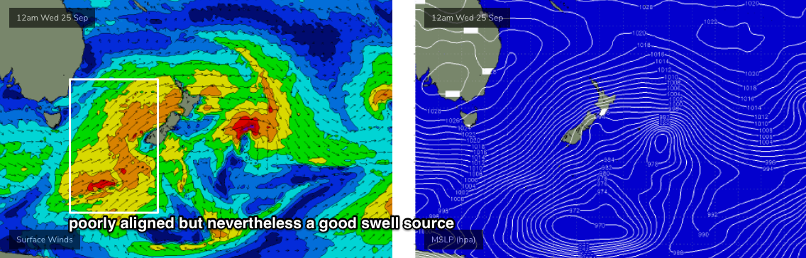
Frontal activity will ramp up through the swell window around the same time, and we’ll see building energy from Wednesday onwards. The storm track is off-axis (see chart below), focused through the eastern Tasman Sea, but it's broad, wide, strong and sustained, so I'm expecting these factors to override its directional deficiencies, allowing energy to spread back into the mainland.
Wave heights will slowly build from the S/SE towards a peak around Thursday afternoon or maybe Friday, ahead of a slow decline into Friday afternoon and the weekend. Max surf size will probably peak around 3-4ft at south swell magnets south of Byron, maybe some bigger 3-5ft sets if we’re really lucky, but it’ll be much smaller at beaches not open to the south. I’m not expecting much size in SE Qld away from exposed northern ends and south facing beaches (exposed Gold Coast spots may briefly reach 2-3ft early Friday).
The fly in the ointment this week is a redeveloping N’ly flow Thursday (Mid North Coast) and Friday (Far Northern NSW and SE Qld). I’ll firm up the specifics in more detail on Wednesday as there’ll be windows of opportunity in and around this (for example, Friday morning across the Mid North Coast) but we need a few more days for the models to consolidate.
This weekend (Sep 28 - 29)
Our upcoming frontal progression will move slightly off-axis later this week, leading to a minor decline in surf size through the weekend - enough to keep south facing beaches (south of Byron) flush with 2-3ft+ sets, but it’ll be a little slower and less consistent. There won’t be much size on offer throughout SE Qld, just a few small waves at south facing beaches and exposed northern ends.
Local synoptics are a little fruity, though Saturday morning looks good with mainly light winds. A weak trough developing off Southern NSW on Saturday may evolve into a closed low by Sunday, and we may see N’ly winds later Saturday and early Sunday. However, it’s quite likely that we’ll see a few windows to work around, as long as you don’t mind the small stuff. Let's take a closer look on Wednesday.
Next week (Sep 30 onwards)
At this stage the general consensus is that we’ll see more fronts pushing through the same part of our southern swell window next week, supplying a similar level of small to moderate south swell for the long term period.
See you Wednesday!
Comments
Hey Ben, I'm sure you've been asked this before, but any chance of separating the forecast a little? Noosa to Newcastle is a shitload of area to cover in one forecast with vastly divergent needs and windows to produce surf-able waves. What about say Noosa to Byron, and Byron south to Newy? Cheers
I concur. Either way, thanks for the reports Ben!
To be honest, in general it’s not needed. Most swells affect broad swathes of the coast and I’ll delve into local effects as required. Otherwise.. I’d be doubling up on a lot of work (I’m very time poor).
What kind of extra information would you like to see?
Thanks Ben, the reports are always awesome, so there's not necessarily anything extra required, it would just help us long suffering Goldie surfers reading three enticing paragraphs before we get to the inevitable "SE QLD is not expected to see any of this" haha.
FWIW, the reverse happens in the summer month trade swell regimes, when I focus on SE Qld, and then usually sum up Northern NSW as being "smaller as you head south from Ballina".
I'd love to do comprehensive forecasts for every region, but I've found the current system is the best use of time. For example, we could also forecast seven days per week (instead of three) but I don't think we'd provide any more value for surfers. In fact, forecasting every day has some downfalls, as it's easier to jump the gun and tweak the outlook for yet-to-arrive swells, when it's not really necessary.
That being said, we are always open to suggestions for how we can improve on what we're doing.
Fair enough Ben - cheers for the reply and keep up the great work!
Craptacular on the Tweed this morning, and I couldn't bring myself to head up to Cooly. Looks fun though, the E'ly swell still seems to be up to 3ft in places.


Even a few runners at Byron!

Not a bad size, actually. Didn't see anything this big on the Tweed!
