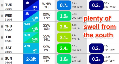
Plenty of swell from the south, but windy at times
Sydney, Hunter and Illawarra Surf Forecast by Ben Matson (issued Monday 29th May)
Best Days: Wed thru' Sat: strong S'ly tending S/SE swell but windy at times. Sun: small clean waves.
Recap: The weekend delivered small, ever-dwindling long range swell from the E/NE, though with lovely clean conditions. Today we’ve began with tiny clean leftovers but a small south swell appears to be glancing the coast at a few south swell magnets. However for the time being it is below Friday’s forecast estimations (it was only expected to influence the Hunter anyway).
Note: our computer model surf forecast graphs will be a little funky for the next day or two.. read more here: https://www.swellnet.com/forums/website-troubleshooting/352217
This week (Tues 30th - Fri 2nd)

The front exiting eastern Bass Strait had its configuration changed slightly (for the worse) over the weekend, so I’m not surprised in there being very little around the grounds today, and am not expecting much to appear overnight either.
We’ll probably see a small uptick in size at south facing beaches, mainly across the Hunter but Tuesday’s set waves will probably be limited to 2ft here with much smaller conditions at remaining beaches.
A cold front pushing up the coast overnight Tuesday will then kick off a fresh short range south swell for Wednesday which will steadily build into Thursday as an anchored southerly fetch adjacent the East Coast becomes supercharged thanks to a series of secondary fronts wrapping around a developing Tasman Low.
This will result in an extended period of fresh S/SW winds from Wednesday thru' Friday or even early Saturday. There’s a chance for isolated, brief pockets of SW (or even W/SW winds) in the early mornings, but these will be the exceptions rather than the rule, and likely limited to a handful of usual suspects such as the Northern Beaches.
As for size, we’re probably looking at a peak in short range southerly windswell on Thursday (4-6ft sets south facing beaches), with a marginally bigger, better and stronger S/SE pulse for Friday originating from the core of the developing Tasman Low. But, this system won’t be especially well aligned for our coast (Northern NSW will see the most size) and with the accompanying southerly winds, those protected locations offering shelter will be considerably smaller.
The Hunter will probably see another foot or two on top of these size estimations.
Let’s take a closer look on Wednesday to assess the possibility of there being periods of good winds on Thursday and Friday to capitalise on. It’s an outside chance but certainly can’t be ruled out right now.
This weekend (Sat 3rd - Sun 4th)
By and large, we’re looking at a steady easing trend in surf size over the weekend though also a rapid easing of wind speeds too.
Friday’s solid S/SE swell will ease from 4-5ft at south facing beaches early Saturday to 3-4ft during the day and 2-3ft into Sunday. We may see a small supplementary E’ly swell on Sunday from a small fetch pushing east of Cook Strait later this week (as the Tasman Low tracks north) but it won’t be worth a lot of size.
Expect smaller waves at beaches not facing due south (however the Hunter may see a little more size on Saturday).
Saturday is at risk of a lingering S’ly breeze (mainly in the Hunter) but elsewhere we should see light W/SW winds, which will persist into Sunday offering a rapid improvement in conditions.
Next week (Mon 5th onwards)
An intense low passing south of Tasmania later this week will set up a small long period south swell for Monday but no great size is expected at this stage. It’s worth keeping a watch on for potential upgrades over the coming days though, including a possible related low forming off New Zealand’s South Island’s West Coast later in the weekend.
Otherwise there’s nothing of major interest in the long term storm track at this point in time. We have an amplifying node of the Long Wave Trough over the Indian and Southern Oceans for next week (west of SA/WA) so it’ll be some time before the feature moves into our region.


Comments
This small south swell is trying hard! Only small at Maroubra but almost rideable.
Ben, sounds like its been an eventful few weeks at swell net with all the server troubles! Do you think the Illawarra region will see 4-6ft sets on Thursday? Thanks
Long flat spells at times, but the odd 1ft+ wave coming through.