Strong swells to continue

Southern Tasmanian forecast by Craig Brokensha (issued Wednesday March 19th)
Best Days: Keen surfers Friday, beaches Saturday morning, keen surfers Tuesday and Wednesday mornings
Features of the Forecast (tl;dr)
- Easing swell tomorrow with gusty N/NE tending N/NW and then W/NW winds ahead of a late W/SW change
- Moderate sized mix of W/SW and SW swells building Fri, strongest later and into Sat AM
- W/NW winds Fri AM, tending variable and E/NE later
- N/NW tending W winds ahead of a late SW change Sun
- Moderate sized W/SW groundswell Sun with weak S winds, easing ahead of sea breezes
Recap
We’ve seen great conditions the last two days with easing levels of swell back from 2ft+ yesterday morning with weak sea breezes into the afternoon. This morning a new mid-period SW swell provided 2-3ft waves but stronger 3ft+ sets are now showing thanks to the arrival of our SW groundswell.

Solid sets this afternoon with the new groundswell
This week and weekend (Mar 20 - 28)
This afternoon’s SW groundswell is due to peak later this evening before easing back through tomorrow, though still coming in at 2-3ft through the morning across Clifton.
Strengthening N/NE tending N/NW and then W/NW winds will create clean conditions all day ahead of a late SW change.
Winds should revert back to the W/NW on Friday morning along with a small 1-2ft wave, though some new mid-period W/SW and SW energy is due into the afternoon, generated by a weakening polar frontal progression projecting to the mid-latitude and weakening on approach to us.
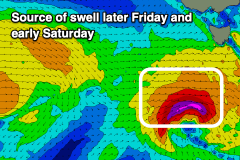
As the low tracks south-east and under us it’s due to re-strengthen, generating a stronger pulse of SW swell for later Friday and Saturday morning to 2-3ft.
Sea breezes on Friday look mostly weak, tending E/NE later with Saturday coming in good under a N’ly offshore, shifting W’ly early afternoon ahead of another late SW change.
Moving into Sunday and our strong W/SW groundswell is on track, with a strengthening low under the country later this week due to project a fetch of W/SW gales through our western swell window.
This should produce a moderate sized W/SW groundswell that is expected to come in around 3ft+ along with what looks to be light to moderate S’ly winds at dawn that will tend variable ahead of sea breezes.
Into next week the outlook remains more than active with the progression of swell generating systems persisting, but more on this Friday.