An excellent run of summer surf, right across the board

South-east Queensland and Northern NSW Surf Forecast by Ben Matson (issued Fri 14th Feb)
Features of the Forecast (tl;dr)
- Strong E'ly swell Sat with pockets of good winds across most coasts (early in the north, later in the south)
- Easing E'ly swell Sat with a S'ly change enveloping the coast
- Large sideband S/SE swell and solid E swell building Mon, peaking by Tues AM, easing thereafter
- Moderate/fresh S'ly quadrant winds Mon, easing Tues/Wed (early SW in most spots)
- More S'ly swell for Northern NSW next weekend
- More E'ly swell the following week
Recap
There’s been plenty of surf over the last few days, with 3-4ft+ E’ly swells on Thursday building to 4-5ft today. Winds have been mixed, with a complex trough driving NE gales across Northern NSW in the early hours of Thursday morning, but S/SE winds pushing up north from the border early/mid morning. Elsewhere, easterlies prevailed. Lighter winds today have allowed for improved conditions.
This weekend (Feb 15-16)
Northerly winds will create some issues on Saturday though in general most coasts will have surfable options at some point.
A southerly change will nose into the Mid North Coast mid-morning, ahead of it we’ll see freshening N’ly breezes though we probably won’t see much strength north from about Yamba in the morning.
The afternoon will likely see freshening N/NE winds across Far Northern NSW and SE Qld (a little less strength on the Sunny Coast), but conversely, we’ll probably see variable conditions settle in across the Mid North Coast after lunch as the change dissolves.
So, aim for an early surf in SE Qld and Far Northern NSW, or a lunchtime thru' afternoon session south from Coffs.
As for surf, our currently E’ly swell should maintain strong 4-5ft sets across most open beaches, potentially some bigger 6ft bombs at the regional swell magnets (mainly in Northern NSW). Bear in mind these freshening northerlies won’t be beneficial for the regional points so you’ll have to coordinate sessions around the wind.
Easing E’ly swells on Sunday should still manage some 3-5ft sets early on (smaller as the day progresses), but freshening S’ly winds will be the dominant wild card to work around as another change pushes up the coast - again, shallow in structure but enough strength to blow out the open beaches.
It’s due into Coffs early morning, and should be close to the border by mid-late morning, reaching the Sunny Coast mid afternoon albeit weakening by this time.
We’ll see some building southerly windswell in its wake, and some associated southerly groundswell across the Mid North Coast late in the day (though Monday is a better chance for this).
Either way, the open beaches up north should offer good beachies early morning, with the regional semi-exposed points favouring the post-southerly afternoon session.
Next week (Feb 17 onwards)
We’ve got stacks of swell for next week too.
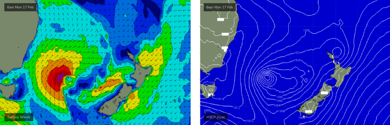
The front associated with Sunday's change is expected to form a deep Tasman Low on Monday, mid-way between Australia and New Zealand. It’ll remain slow moving, a factor that when combined with gale force winds slingshotting around its western flank (see below), should offset its poor alignment within our swell window.
The fetch will be mainly aimed towards New Caledonia and Fiji, but we should see a reasonable spread of S/SE groundswell back into the East Coast of Australia.
Although SE Qld doesn’t usually fare well (in the size department) from th this swell direction, we also have a strong renewal of easterly swell on the way, from current activity along the monsoon trough south of Fiji.
As such, I’m expecting a mix of building swells from both directions on Monday that will peak into the afternoon in the 5-6ft range across most exposed coasts (slightly smaller along the regional points in SE Qld).
Exposed south swell magnets south of the border may pick up some bigger bombs into Tuesday morning from the longer period south swell (plus the combined effects of dual swell trains) though both energies will gradually ease into the afternoon and further into Wednesday.
As for conditions, we’re looking at fresh southerly quadrant winds on Monday, easing slowly through Tuesday and Wednesday. Each morning should see a slight SW bias to the wind direction. This means we’ll see an extended run of quality options across the points.
Looking further ahead and the end of the week will see small, more subdued surf conditions ahead of a modest southerly swell across Northern NSW next weekend, and another extended run of E’ly groundswell during the first half of next week as the monsoon trough re-establishes itself across the Coral Sea and South West Pacific. This is expected to generate another long-lived pulse of quality summer swell for the majority of the East Coast.
Have a great weekend, see you Monday!
Comments
Remember only a few weeks ago we were all so sour at how bad the run had been, stoked that's now in the rear view mirror
lol I was just thinking the same. I’m sure I can find something else to complain about. Weekend warriors or such …
It’s been a summer of two halves.
December and January were woeful, February has been non stop. The extended forecast runs to end of the month so if it delivers what’s expected it will mark out February as another standout month for the subtopics.
There's been plenty of swell through Feb but wave quality here has been very poor.
Yesterday morning being a classic example- 4-5ft of clean E swell and just nowhere really making sense of it.
Yeah I tend to agree. It has been pretty forgettable to be honest. But better than flat, and hopeful times ahead.
Will be interesting to see whether the perspective changes after Monday.
Great detailed report, thx Ben
Hi Ben. Just a question if I may please.
“As such, I’m expecting a mix of building swells from both directions on Monday that will peak into the afternoon in the 5-6ft range across most exposed coasts (slightly smaller along the regional points in SE Qld). ”
Are you saying it should be 5-6ft out of the east also by Monday afternoon?
Kinda, yeah. Whilst the SSE swell looks to be the strongest and largest of the two (though less favourably aimed towards our region), the east swell has a similar size potential - albeit a different kind of swell (broader size plateau; more distant source thus less consistent), and I feel that some exposed beaches could easily deliver that size range (and more) as the two swell trains interact in the near shore zone.
Of course, it's all in the interpretation. Don't be expecting 5-6ft sets across the SE Qld points etc, though they should have very good waves.
Powerful waves northern sc this morning. Was very fishy. I'm sure I saw an ominous looking fin and a tail fin out at Sunrise, could have been a dolphin. Packed it straight back in. Had already snapped a leg rope string and had to swim in, wasn't up for that again. No one else seemed concerned, some cracking waves for those willing to take them on.
I scored some solid left hand barrels this morning at a semi hidden spot. You just need to know where to go…..
Pass cam is interesting this morn.
5.40 some weird light thing flew through the sky top right of screen.
Guy surfing 5.53 into 5.54 turns head torch on after taking off.
I think he surfed a few others but that was the longest.
Absolutely pumping, barrels everywhere, some total drainers too.
Best day in a very long time, shoulders are cooked.
how busy it, never seen it like that
Few nice ones on the points again today, little smaller and less consistent then it's been, but it was also cleaner.
And that's an impressive cyclone forecast to form near Fiji late this week, hoping it doesn't cause the locals any trouble.
Rest in peace Tommy Peterson
Coolangatta forever!
has the forecast been downgraded? i was expecting a little more size this arvo and tomorrrow morning, but the chart numbers have dropped
Beachies south SC very good this am
certainly were roy
Pretty damn solid energetic mix of swells here this afternoon.
Both the S and E angled swells were in the 4-6ft range and maybe some of the S ones were even a notch bigger.
Lots of paddling, lots of sets on the head and thus uncrowded. Bit of fun if you found a good one.
Emery or DS?
Good to see you guys finally getting some proper waves. DEAD flat here yesterday, and 1ft today.
I rode the 6'6" DS- just for the paddle....big, big playing field.
I got washed way past the hut before I had even started.