Tiny weekend in the north, ahead of a big week from the south
Southeast Queensland and Northern New South Wales Surf Forecast by Ben Matson (issued Friday 2nd May)
Best Days: Late Sun: new south swell showing in the Lower Mid North (probably not reaching further north than Port Mac or Coffs). Mon/Tues: solid south swell in Northern NSW (small in SE Qld). Late Wed/Thurs: another solid south swell for Northern NSW (small in SE Qld). Fri: could be centrestage for SE Qld with a new system developing right off the coast?
Recap: Small residual leftovers. Nothing of any great interest.
This weekend (May 3-4)
Let’s split the weekend into two region - north and south of the border.
SE Qld won’t see anything but a whole lotta offshore wind both days. Next!
Northern NSW can almost cut n’ paste the SE Qld forecast for the weekend. That is, if you’re located north of Coffs Harbor.
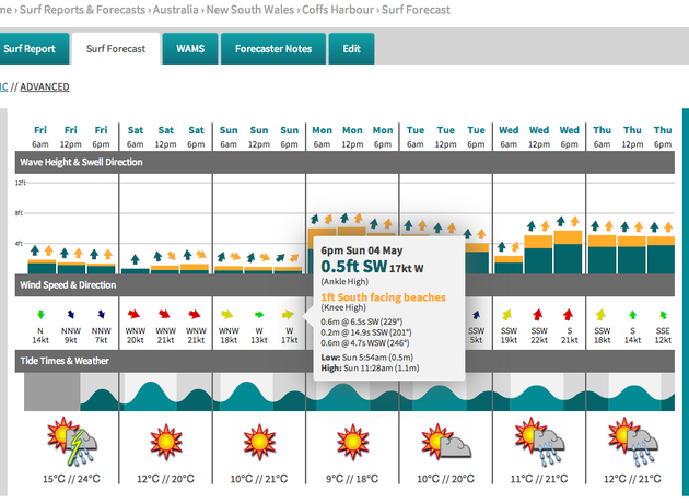
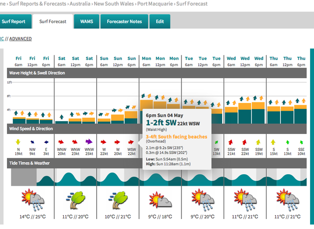
See, we’re expecting a building south swell from an incredible low pressure system developing in the SW Tasman on Saturday, but model data has the leading edge pushing just into the Port Macquarie region by the end of the day (with 3-4ft sets at south facing beaches late afternoon). See at the bottom of this report for comparison graphs between Port Mac and Coffs.
Now, model derived forecasts are an inexact science at the best of times. So if I were positioned somewhere between Port Mac and say, Yamba, about mid-afternoon on Sunday, I don’t think it’d be unreasonable to glance an expectant eye across the coast in hope of some early forerunners. Because winds will be offshore (out of the west) and once the swell eventually hits it should be reasonably consistent, and will only continue to build.
I’d recommend keeping an eye on the Sydney surfcams in the morning just to confirm its arrival (particularly the Newcastle surfcam, which shows south swells really well) and then the Coffs Harbour surfcam which faces due south too. If it's starting to look sizey at Newcastle by early afternoon, it could be game on.

Otherwise, Monday is your day.
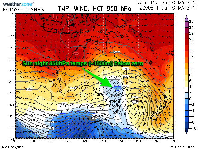
As a side note, check out the 850hPa temps across the Central/Northern Tablelands on Sunday night (blue area in the image to the right) - this equates to around 1500m above sea level and temps dips below zero (happy camping!). This system will deliver an icy smack in the face for those of you who’ve been enjoying the relative warmth in boardies over the last few months - the wind chill is going to bite hard over the next week or so.
Next week (May 5-9)
This Tasman Low is shaping up to be quite a beast. However, most of SE Qld rarely benefits from southerly groundswells unless they’re massive and this one won't tip the scales. So, we can expect very small waves across much of the Gold and Sunny Coasts throughout next week as a series of south swells moves through the region (however, exposed south facing beaches will pick up some decent waves).
But across Northern NSW, Monday should see a large south swell generated by a near-stationary, continually strengthening fetch of gale to storm force S/SW winds forming between Tasmania and up to about Jervis Bay later Saturday and into Sunday. The swell will already be in the water across the Lower Mid North Coast early Monday, but the Far North Coast and exposed south swell magnets in SE Qld will start off smaller and slower ahead of a rapid increase throughout the day.
Due to the acute southerly swell direction, we’re looking at a large range in wave heights - anywhere from 5-6ft bombs at south facing beaches (perhaps some bigger waves in the Lower Mid North), down to maybe 2-3ft sets at open beaches with tiny waves inside sheltered southern corners.
Exposed south facing beaches on the Gold and Sunshine Coast won’t pick up much as much size as its magnetic counterparts south of the border, however 3ft sets are a reasonable possibility here (very late Monday or more likely early Tuesday). And winds are looking good too, moderate to fresh W/SW across the Lower Mid North with lighter W/SW winds and sea breezes north of about Yamba.
A slow easing trend is then expected through Tuesday, ahead of yet another strong south swell building throughout Wednesday, courtesy of another low and front tracking through the southern Tasman Sea earlier in the week. This should deliver a similar round of swell (as per Monday) across south facing beaches through the middle of the day in the south, but it'll arrive late afternoon in the north.
There’s a chance SE Qld’s exposed south swell magnets may not see this new pulse until after dinnertime Wednesday (so, with Thursday being your best chance for the most size), however I’ll revise all of these timings on Monday with the availability of updated model data.
As for winds, the font/low responsible for the mid-week swell looks like it’ll punch a little further north than previous systems, so winds are looking dicey for the lower Mid North Coast - some form of southerly - however we should see a SW outflow north from about Coffs or Yamba through the the Sunny Coast.
Strong but slowly easing south swells are then expected from Thursday through Friday with good winds.
Longer term (May 10 onwards)
More south swell is on target for next weekend at this stage, extending from a polar front expected to track well south of Tasmania Wednesday/Thursday and then up into the New Zealand region (current model guidance points towards a smaller, longer period event with much less consistency).
Elsewhere - and more relevant to the SE Qld region - we’ve got a complex trough developing on the long range models just off the SE Qld coast later next week that could deliver some interesting possibilities for Friday, Saturday and Sunday. It's way to early to start discussing options here but worth flagging for discussion on Monday. ‘Till then enjoy your weekend!


Comments
My gut still says the second southern low will be better for qld..... And no takers re' bomb? Free ride? Don? Want me to make the call? Blow the whistle? Sweet mary mother of god? ;)
A bit of a change in the writing style TB, I like it.
Thanks Mitch.
SD - ACCESS and GFS have ramped up this low in the last few runs. EC doesn't want a bar of it right now, but its performance has been a little underwhelming in this region over the last few months. So confidence is somewhat lifted for a significant short range swell event in SE Qld this weekend.
So what are the south facing beaches on sunny coast.
Yaroomba? Mudjimba? Wurtulla? Maroochy?
None really, wurtulla was tiny during the last southerly swell.
So what are the other south facing beaches? Peregian?
kings is south facing but is it too blocked by moreton for the southerlies to wrap through with any height?
Kings was the best I could find, was quite suprised
Good for lidding, if you can get one from amongst the tight local crew.
Sorry Doggie, been at work.
Vorticity in the trough line forms surface low Fri off Fraser generating gales on the southern flank. Rapid rise Fri arvo with Noosa outer Bays into the 3-5ft range. Pumping surf at the Superbank....onshore for most of NENSW.
Surf pumping Sat morning before dropping quickly late as the low races away.
There ya go.
Almost spot on with what our models are forecasting as well Steve..
Late tropical burst indeed! For my part still a little bit of movement depending on how deep the trough gets but at least there'll be something.
Fair call free ride.... fair call..... BTW, the second southern low sweeping up from under tassie.... Check its form out here Monday thru wednesday
http://www.metvuw.com/forecast/forecast.php?type=rain®ion=swp&noofdays=7
Actually scrub that SD....looks like models have dismissed the Fraser low altogether.
Now back to reality. Is this current s'ly swell moving up the coast ahead of schedule? Ascat passes from yesterday appeared to show the low pushed east of tassie a little earlier than modelled?
South swell seems to be on schedule at the moment Don. Although still not enough data to be sure. Will have a better idea by lunch/early arvo.
free ride. Still should get at least trade swell. Don's favorite site actually has a less radical but possibly better (quality wise ) set up a couple of days late....
Check accesg for 13/5th..... Still maps in low just south of new cal with nice fetch under it..... Not huge, but less wind..... Cleaner.....
Donnys other favorite, (bellmere weather) has 2 separate lows forming, one late on the 9th, another on the 13th just off Brisbane.... My favorite ( metvuw) has no low..... Confusion with different models suggests still worth watching...
Btw.... I really really REALLY like the look of that secondary tasman low interacting with the first low ( in map supplied above earlier in thread)..... Geez..... Free ride - your south swell spots, hey? Lookn good.....
OZcyclone chasers have been running a "model wars" comparison over the last week, ACCESS did pretty poorly :(
EC & UK at the top
GFS surprisingly poor
Suss it out if you want more detail, I have questions about the assumptions (just to clear things up in my head) in the statistical analysis used. But for general chat, pretty good analysis
Ben, i was chatting to Donweather about a tropical low out past NZ..... I know all eyes are focused south atm, with good reason..... But the little low is being nicely cradled....
Check your 21/3 notes..... tc mike came in at 5 - 6 feet or so.... This current system is slightly weaker......
Your opinion on a long east swell around late wed' early thurs? - at 3 foot? Inconsistent?.....
http://www.metvuw.com/forecast/forecast.php?type=rain®ion=swp&noofdays=7
SD I know you asked Ben but I'll chime in here too. On the projected (?, i.e. animation on a map) wave models, the E swell is swamped out by the S. Swellnet has 13.5sec arriving by midnight Th/fri, WWIII on stormsurf looks to have an arrival of 13-14sec around 10am Thursday; magics 12sec on Fri nooon. I can't really see it on windguru. And seabreeze has 14.5sec on Thu at 1pm. Finally, on AUSWAVE G, I can see 14sec hitting NZ NI from the ESE on Mon 10pm.
I left off heights intentionally.
It's an interesting system though, retrograding equatorward, if that's a thing.
I may aswell throw my hat in the ring anyway though, I don't think it'll be recognisable in the surf. At best, on the Byron spectra, it might show up as sub 13sec sub 1m... in isolation in the surf, 2ft. I think if it stayed dead stationary or retrograded west for a day, then maybe...
One last thing. Ben, do you mind removing h... *edit* nevermind.
holy crapzilla is it just me or has the next frontal system been ramped up to the max!?!/ I might target one of those 11 spots SD!
Ahhh what would I know mitch ;)
That's right. Being an ostritch, I can feel groundswells in the sand way before you can see them from the farm :P
Hahahaa..... You're a crack up, Mitch ;).... Mate.... Last night was bad joke.... Ya try to help people, have a bit of fun... And trolls come along.... My own fault for scooping down to their level.... I do hope joaske keeps on studying weather... Anyway, live and learn....
I note that pacific low has sat there, mitch..... If we didn't have a dynamic "southern situation", I'd suspect a few more eyes would be looking eastward....... And that second southern low interaction looks like a doozy....... Maybe even a few "points" down here may fire up...
Haha mate I've been caught up in a fluster before myself. Anyway, I'll keep an eye on it, lock it in the vault whatever transpires. Probably be 8 years (statistically) until we're at this point again with ENSO... it has been an epic run.
Severe undercall on this stretch of coast this morning.
What would you be calling it 76?
It's 4-6ft at semi-exposed Points and much bigger at S facing beaches.
and do you have any thoughts on how they got it so wrong?
Certain period signatures get into certain parts of the NSW N. Coast with greater or lesser power. This one was a good hit on this stretch.
Absolutely rooted after a massive days surfing. Some solid bombs where I was today.
Satisfied 'customers' on the Surfari DW?
Satisfied and rooted all at the same time!! :)
Haha charming
Do you guys get bored from deconstructing every little model update. I get that surf forecasting can be an exiting and interesting pursuit but you blokes take it the next level. The surf will come and surely the realisation that beyond three days all those models, with regard to the east coast, can be erratic at the best of times has dawned.
Bored? How could anyone be bored with such a fantastic looking synoptic map? I'm getting all hot and sweaty just pasting the image code.
Yeah Dudettie, Hard on stuff.
Welly! Charging South Strad this week?
Rub it in Mitch, Very Good.
Wrong side of the country doing that nasty 4 letter word thingey.
Doooh.
Ahhhh thought that might be the case. My housemate is too. Can never convince/show him good surf on the sunny coast cos he goes away
What do you think Braithy ?