Large swells to come with plenty of west wind
South Australian Forecast by Craig Brokensha (issued Wednesday September 18th)
Best Days: South Coast all period until Wednesday, Mid Coast Monday afternoon and Tuesday
Features of the Forecast (tl;dr)
- Moderate sized mid-period SW swell building today with strengthening N/NW tending W/NW winds
- Mix of swells tomorrow with strong W/SW winds (W/NW early South Coast)
- Large SW groundswell building through Fri and peaking into the PM with strong W-W/NW winds
- Large easing swell Sat with strong W/NW-W winds
- Temp drop in size Sun with fresh to strong but easing W/NW tending W/SW winds
- Large S/SW groundswell for Mon, peaking through the day with moderate N/NW winds, tending variable across the Mid Coast and W/NW down South
- Large SW groundswell Tue with local offshore winds and weak sea breezes
- Easing surf Wed with strong SW tending S/SW winds
Recap
Yesterday morning started a little lumpy but the strong pulse of swell seen into Monday afternoon held with 4ft sets across Middleton as offshore winds slowly ironed out the lumps/bumps. The Mid Coast was tiny and became wind affected quickly.
This morning we’ve got a temporary drop in swell to 3ft across Middleton with cleaner conditions and a fresher offshore wind, but some new mid-period SW swell should kick to 4ft through the day as winds shift W/NW.
This week and weekend (Sep 19 - 22)
Today’s moderate sized pulse of SW swell is due to peak through the afternoon, with it easing back in size tomorrow morning from 3-4ft across Middleton, tiny inside the gulf. Conditions won’t be as favourable with strong W/SW winds developing during the day, W/NW early and lighter around Victor early. The Mid will see building windswell into the afternoon.
Also into the afternoon, building levels of mid-period SW swell are due ahead of a larger, more significant SW groundswell into Friday.

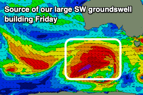
The source of both these swells is a strengthening polar low that’s currently south of Western Australia, with it due to produce a great fetch of severe-gale W/SW winds while projecting slowly towards Victoria over the coming days.
The size expected off this system has been upgraded a touch since Monday, with Friday due to see large levels of mid-period swell through the morning with longer period groundswell energy into the afternoon/evening.
The South Coast should build to the 6-8ft range on the magnets with the Mid Coast coming in at 2ft, easing slowly from a similar size on Saturday down South. The Mid Coast should hold 2ft most of the day as some reinforcing mid-period swell fills in.
Winds will unfortunately only favour protected spots on the South Coast with a strengthening W/NW-W breeze Friday, holding from the W/NW on Saturday but with strength. Sunday will then see fresh to strong W/NW winds, easing and tending W/SW through the day.
Moving into next week and we’ve got out secondary large swell producers on the cards, with another strong polar low due to develop south of Western Australia Friday night, projecting a tighter fetch of gale to severe-gale W/SW-SW winds towards us with embedded storm force winds.
This will generate a large S/SW groundswell for Monday that looks to come in around the 5-6ft range across Middleton, possibly a little undersized early, with slower 2ft sets continuing across the Mid Coast.
A secondary stronger low rushing in quickly behind the first will generate a fast moving severe-gale to storm-force fetch of W’ly winds through the weekend.

This should produce a larger SW groundswell for Tuesday more to 6ft to occasionally 8ft, but check back here on Friday for confirmation on this.
Winds through this period look better and lighter with a moderate NW’ly across both coasts Monday, tending variable into the afternoon across the Mid Coast and W/NW down South, locally offshore Tuesday ahead of weak sea breezes.
Easing surf with strong SW tending S/SW winds is then due Wednesday, S/SE Thursday but check back here Friday for more on the longer term outlook.

